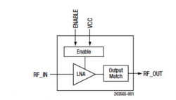
Industry View category Archives - Page 47 of 63 - Inside GNSS - Global Navigation Satellite Systems Engineering, Policy, and Design

Industry View category

January 16, 2013

NovAtel Announces New BeiDou Capability for Its GNSS Products

NovAtel has announced support for the BeiDou Navigation Satellite System on its OEM6 family and selected OEMStar GNSS receivers.

The long-anticipated BeiDou Interface Control Document (ICD) release is a
significant milestone that facilitates global acceptance of the Chinese
GNSS system into the growing range of satellite-based positioning
applications, the company says.

Read More >

By Inside GNSS
January 12, 2013

VectorNav Supplies IMU for Unmanned Innovation Autopilot Development Platform

Unmanned Innovation, a provider of development platforms for unmanned aircraft systems (UAS), has partnered with VectorNav Technologies to integrate VectorNav’s VN-100 inertial measurement unit (IMU) into Unmanned Innovation’s os-Series Autopilots.

The VN-100 uses the same base IMU components (gyro, accelerometer, magnetometer) that are used to support the VN-200 GPS-aided integrated navigation system surface-mount chip that VectorNav introduced at this year’s Association for Unmanned Vehicle Systems International (AUVSI) North America conference.

Read More >

By Inside GNSS

Spirent Adds BeiDou Capability to Its GNSS Simulators

Spirent Communications has announced the availability of test systems with support for China’s BeiDou Navigation Satellite System in addition to GPS, GLONASS, and Galileo.

Spirent’s positioning and navigation group based in Paignton, United Kingdom, started shipping BeiDou-ready test systems to customers in 2012. The company’s equipment will now be upgraded to full BeiDou capability using the information from the recently released first full issue of the BeiDou-2 Signal-In-Space Interface Control Document (ICD).

Read More >

By Inside GNSS
[uam_ad id="183541"]
January 8, 2013

Septentrio Tracks BeiDou GNSS Signals Using New ICD

Figure 2. L1 pseudorange residuals (m) for GPS (L1 C/A, top) and COMPASS (B1-I, bottom) vs. time of day (hour).

Septentrio reported today (January 8, 2013) that the Belgium-headquartered GNSS receiver manufacturer has successfully computed a position/velocity/time (PVT) calculation using BeiDou/Compass satellites in a three-constellation (GPS+GLONASS+BeiDou) solution.

"We are positively surprised of the better than expected performance coming out of what we characterize to be ‘a quite mature constellation,’” Laurent Le Thuaut, Septentrio’s business development manager, told Inside GNSS in an e-mail.

Read More >

By Inside GNSS
January 3, 2013

Trimble Acquires ALK Technologies

Continuing its string of acquisitions in recent years, Trimble announced today (January 3, 2011) that it has acquired ALK Technologies Inc., a privately held Princeton, New Jersey–based company that offers proprietary routing and international map-based solutions for transportation, logistics and mobile workforces.

Read More >

By Inside GNSS
[uam_ad id="183541"]
October 29, 2012

Indoor Navigation Smartphone App wins 2012 Galileo Masters Prize

Presentation of the 2012 €20,000 Galileo Master prize: (L to R)) Thorsten Rudolph, head of AZO, the contest organizers; Carlo des Dorides, head of the European GNSS Agency; winner Dirk Elias, Fraunhofer Portigal and Ulrike Daniels, AZO business development. (photo: Simone Hörmann/AZO).
The 2012 ESNC awards ceremony at der Residenz, Munich (AZO photo)

Finding your way will be even easier with a new smartphone app from two Portuguese research institutes that augments GNSS with ultra-low magnetic field communication (ULF-MC) for reliable navigation in office buildings, airports, underground parking garages and other indoor locations.

Read More >

By Inside GNSS
October 12, 2012

Trimble Introduces Next Generation GNSS Survey, Datalink, Mapping Solutions

Trimble R10 rover

Trimble has introduced its next-generation GNSS surveying solution — the Trimble R10, a small, lightweight receiver that introduces new features and technologies, including Trimble HD-GNSS, Trimble SurePoint, Trimble 360, and Trimble xFill, to provide increased productivity.

Announced at the Intergeo 2012 conference in Hannover, Germany, this week, introduction of the Trimble R10 was accompanied by new versions of its field and office software — Trimble Access 2012.20 and Trimble Business Center 2.80 to extend Trimble’s Connected Site survey solution.

Read More >

By Inside GNSS
1 45 46 47 48 49 63
IGM_e-news_subscribe