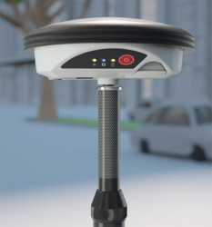
 Leica Zeno GG04 smart antenna. Photo source: Leica Geosystems.
 Heerbrugg, Switzerland-based Leica Geosystems announced today the new Leica Zeno GG04 smart antenna, enabling a flexible solution to improve mobile devices’ GNSS accuracy with real-time kinematic (RTK) and precise point positioning (PPP).
Heerbrugg, Switzerland-based Leica Geosystems announced today the new Leica Zeno GG04 smart antenna, enabling a flexible solution to improve mobile devices’ GNSS accuracy with real-time kinematic (RTK) and precise point positioning (PPP).
Paired with the Zeno GG04, any Zeno or third party mobile device with Android or Windows OS can now collect highly precise positioning data with Leica Geosystems’ GNSS technology and 555-channel tracking performance, according to the company. With PPP, users can collect data even in areas without cellular coverage. The bring-your-own-device (BYOD) functionality enables any smart device to collect survey-grade data, delivering centimeter results.
“We’re excited to hear about the new Zeno Connect for Android. Being able to connect any Android device to the new GG04 antenna and use it for field data capture is a real game-changer,” said Zenny Chareas, project manager at PeopleGIS, a firm that builds web-based database applications for field collection currently using the Leica Zeno GG03. “Our clients have been eagerly anticipating this type of functionality, and it’s pretty cool that we now have a solution for them.”
Precise Geopositioning Just an App Away
With the Zeno Connect app, any third-party app is compatible with the Zeno GG04 smart antenna. The Zeno Mobile, Zeno Connect or Esri’s Collector for ArcGIS apps provide an easy and familiar platform for non-surveying professionals to collect and analyze data. Organizations can now integrate and enrich data in real time from different sources to collect all details of any project from anywhere in the world, regardless of how remote, according to Leica Geosystems.
“Wherever users are working, despite, how rough the environment, the Zeno GG04 ensures all needed data is easily and accurately collected,” said Alexander Fischer, Leica Geosystems Zeno product manager. “The flexibility offered by turning our most common devices into precise instruments increases access to the geopositioning world, and this is certainly an exciting advancement to share technology and information with new segments.”
Additional Product Details
Described as rugged, flexible and easy-to-use, the smart antenna not only uses RTK technology but can now apply PPP. This now makes real-time, high-accuracy data collection possible in the most demanding of locations without the need for a mobile data connection.
With its compact, lightweight design and IP68 durability, you can work for longer in all conditions, and bring high accuracy mapping to your fingertips, according to the company.
PPP works by using a satellite-based correction service to broadcast data directly to the GG04. Corrected data is processed onboard the antenna and delivered seamlessly to your device. PPP is available anywhere in the world at any time. It can mount on a pole, backpack or vehicle, and the antenna’s scalable performance can be tailored to fit your needs.
With 555 channels, it is designed to provide more signals, fast acquisition, and high sensitivity. The antenna delivers satellite signal tracking for GPS (L1, L2, L2C, L5), GLONASS (L1, L2), BeiDou (B1, B2, B31), Galileo (E1, E5a, E5b, Alt-BOC, E61), QZSS2, SBAS (WAAS, EGNOS, MSAS, GAGAN), and L-band.


