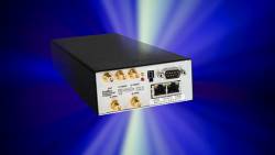
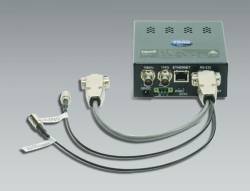
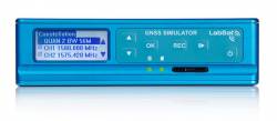
NovAtel’s GPS Anti-Jam GAJT On Board Schiebel’s UAV
NovAtel GAJT-AE-N antijam electronicsNovAtel’s compact GAJT anti-jam antenna is now on-board the CAMCOPTER S-100 Unmanned Air System (UAS) from Austrian manufacturer Schiebel.
By Inside GNSS
NovAtel GAJT-AE-N antijam electronicsNovAtel’s compact GAJT anti-jam antenna is now on-board the CAMCOPTER S-100 Unmanned Air System (UAS) from Austrian manufacturer Schiebel.
By Inside GNSS
Trimble MB-Two moduleTrimble has introduced its dual-antenna MB-Two GNSS module, which delivers GNSS-based heading plus pitch or roll in an industry-standard form factor for system integrators.
According to Trimble, the module’s embedded Z-Blade GNSS technology uses all available dual-frequency GNSS signals equally, without any constellation preference, to deliver fast and stable centimeter-accurate position and heading information. The MB-Two is designed as a solution for a variety of applications such as unmanned, agriculture, automotive, marine, and military systems.
By Inside GNSS
u-blox has released its 8 module series that addresses user needs for power-sensitive operation. A derivative of the u-blox 8 GPS/GLONASS receiver platform launched in January, the module is related to the u-blox M8 platform that targets applications where navigation performance and high accuracy are paramount.
By Inside GNSS
In this photo, the red illumination represents light moving through the FOG’s optical circuit of coiled fiber; this circuit is the FOG’s sensing unit and can be mounted with power and processing electronics within a driverless car to provide precise data for the car’s navigation systems. KVH photoKVH Industries, Inc., says that it is developing a fiber optic gyro (FOG)–based, low-cost inertial sensor for self-driving cars, based on its successes in autonomous vehicle prototype programs and a wide range of unmanned applications.
The Middletown, Rhode Island–based company also announced that it has introduced a developer’s kit to support integration and testing of FOG-based inertial measurement units (IMUs) for driverless cars.
By Inside GNSS
NovAtel Inc. has announced the launch of its TerraStar-L, a new 40 centimeter precise point positioning (PPP) correction service. TerraStar-L is a subscription based correction service that delivers GNSS correction data via satellite to users of precision navigation systems.
The company says that position accuracy of 40 centimeters makes TerraStar-L ideal for broad accuracy applications such as agriculture, GIS or unmanned vehicle navigation, particularly where tree lines, buildings and other obstructions can be an impediment to continuous positioning.
HX-DU1603D datalink radioHarxon Corporation has launched the HX-DU1603D, a high-speed, Bluetooth-enabled, wireless data link designed for GNSS/RTK surveying and precise positioning.
The HX-DU1603D is a lightweight, ruggedized UHF receiver designed for digital radio communications between 410 and 470 MHz in the radio frequency spectrum using either 12.5- or 25-kilohertz channels.

Kai Borre, now a professor and senior researcher at Russia’s Samara State Aerospace University, has released a new version of Easy Suite, a collection of Matlab-based scripts and explanatory text that illustrated a variety of common GPS issues.
The first Easy Suite files (easy1–easy10) were published in the periodical GPS Solutions in 2003. Those were augmented by a continuation (easy11–easy18) in Inside GNSS in the years 2009–2010.
HX-CH6601A antenna
HX-CH6601A antennaHarxon Corporation, a large antenna manufacturer based in Shenzhen, China, has launched a new GPS L1/L2 GLONASS L1/L2 BDS B1/B2 helix antenna for unmanned aerial vehicle (UAV) and geographic information system (GIS) applications.
According to Harxon, the HX-CH6601A helix antenna offers significant improvements over its predecessor HX-CH4601A GPS/GLONASS L1L2 antenna, by providing exceptional pattern control, polarization purity, and high efficiency in a very compact form factor.
By Inside GNSS
OriginGPS has launched its Multi Micro Spider multi-GNSS module, which features a 5.6 x 5.6-millimeter footprint and 2.65-millimeter height.
Like its predecessor, the Multi Micro Hornet (which measured 10 x 10 x 6.1 millimeters), the ORG4033 uses MediaTek’s MT3333 and is positioned for applications that require minimal power consumption and ultra-small form factors, ranging from wearables to drones. Unlike the Hornet, the Multi Micro Spider supports Europe’s Galileo system as well as GPS, GLONASS, and BeiDou.
By Inside GNSSNEO-M8P.jpg)
u-blox continues to roll out variations on its new generation of GNSS technology, launching the NEO-M8P receiver modules targeted at such applications as unmanned vehicles and robotic guidance systems
By Inside GNSS
u-blox modulesThalwil, Switzerland–based u-blox has announced the upcoming release of a new firmware, FW 3.01, for its u-blox M8 multi-GNSS platform.
u-blox M8 FW 3.01 will now also support Galileo in addition to GPS, GLONASS, BeiDou. It can track up to three constellations concurrently and makes use of all satellite-based augmentation system (SBAS) signals and Japan’s Quasi-Zenith Satellite System (QZSS) at the same time, according to the company.
By Inside GNSS
First GPS III satellite in acoustic testing last fall. Lockheed Martin photoHarris Corporation has announced that it will offer an all-digital navigation payload for GPS Block III space vehicles (SV) 11 and beyond.
By Inside GNSS
Swift Navigation’s Piksi GPS receiverHaving started out with a crowd source–funded launch through Kickstarter followed by two rounds of more conventional venture capital backing — $2.6 million in 2014 and another $11 million last December — San Francisco, California–based Swift Navigation is going after a low-cost, high-precision market such as unmanned aerial vehicles (UAVs) with its Piksi GPS receiver platform.
By Inside GNSS