Hidden Siblings of the GNSS
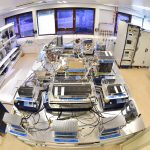
GPS keeps a digital twin sequestered in El Segundo, California. Galileo has an Earth-bound space vehicle in Noordwijk, the Netherlands, straining at its bonds, yearning to break free and fly with its brethren. Both constellation “ghosts” exist in an eerie testing twilight, being made to replicate the movements and reactions of their free-flying families. Their sacrifices could lead to better, more robust satellites in future generations.
By Alan Cameron