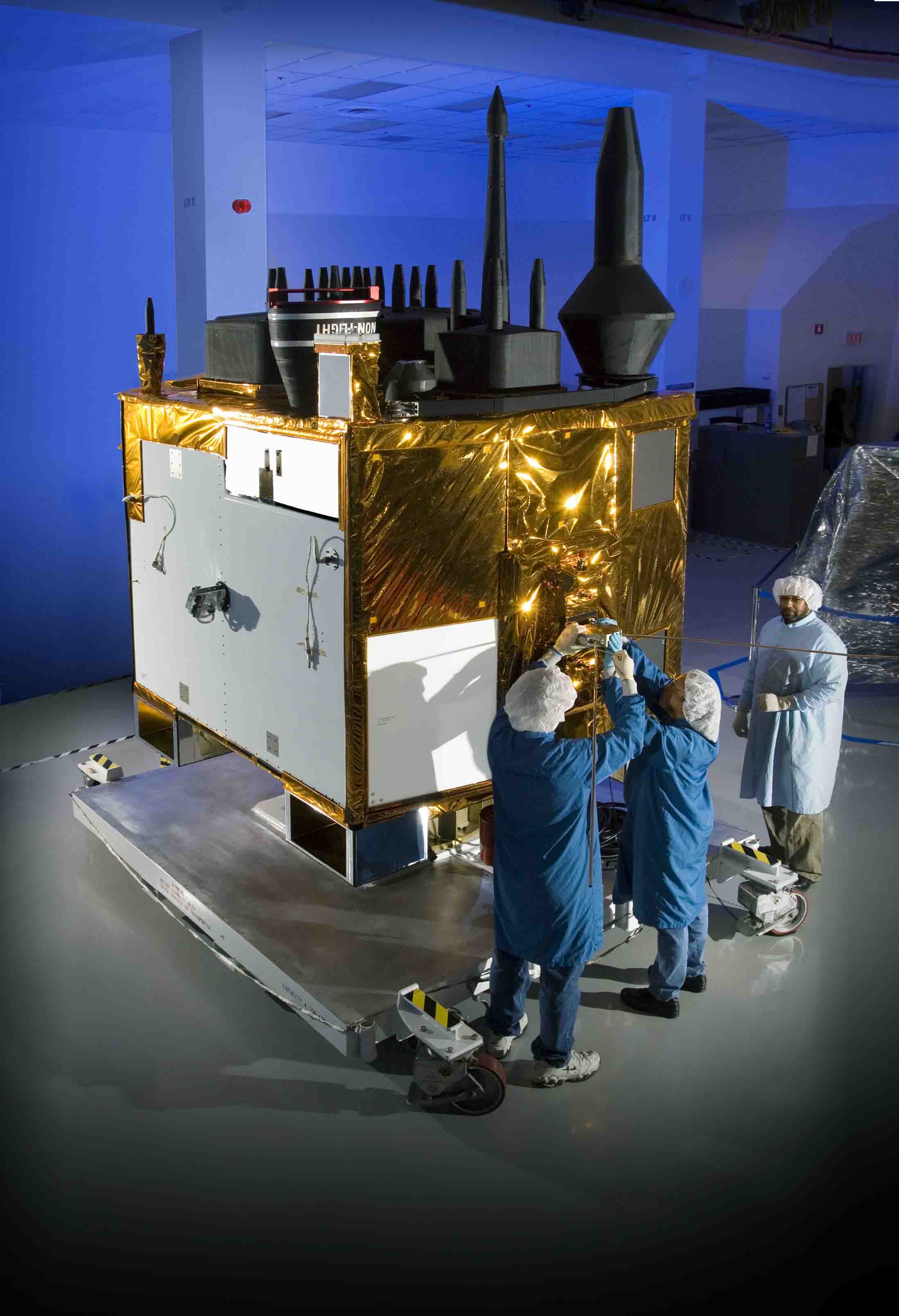
Obama 2010 GPS Budget Calls for $1 Billion+

The president’s proposed Fiscal Year 2010 (FY10) budget would provide more than $1 billion for GPS and related U.S. space-based positioning, navigation, and timing (PNT) programs.
By Inside GNSS
The president’s proposed Fiscal Year 2010 (FY10) budget would provide more than $1 billion for GPS and related U.S. space-based positioning, navigation, and timing (PNT) programs.
By Inside GNSSThe theme of the 2009 IAG Scientific Assembly is "Geodesy for Planet Earth." It will take place at the Intercontinental Buenos Aires Hotel in the historic district of Montserrat from August 31 to September 4.
Register online at http://iag2009.com.ar/registration/
Sessions and sub-sessions of particular interest to Inside GNSS readers:
By Inside GNSS
As if a puzzling signal anomaly on the latest GPS Block IIR-M satellite and continued struggles in the long-delayed Block IIF schedule hadn’t created enough pressure, a recent U.S. Government Accountability Office (GAO) report sketches dire prospects for the GPS program.
By Inside GNSSThe solar wind plays havoc with GNSS ground and space segments – destroying electrical transformers and the electronic systems on satellites.
In fact, space weather is the single largest contributor to single-frequency GPS errors and also to differential GPS.2. And right now, we have only three years until the next Solar Max.
By Inside GNSS
Brad AndersonRosum Corporation, the Mountain View, California–based supplier of timing and positioning technology that combines GPS and broadcast television signals, has named Brad Anderson as the company’s new chief executive officer.
By Inside GNSSOfficials from Air Force Space Command’s Space and Missile Systems Center’s GPS Wing have announced the release of a request for proposal (RFP) for Phase B of the Next Generation GPS Control Segment (OCX) contracts.
By Inside GNSS
One of 12 magnetograms recorded at Greenwich Observatory during the Great Geomagnetic Storm of 1859
1996 soccer game in the Midwest, (Rick Dikeman image)
Nouméa ground station after the flood
A pencil and a coffee cup show the size of NASA’s teeny tiny PhoneSat
Bonus Hotspot: Naro Tartaruga AUV
Pacific lamprey spawning (photo by Jeremy Monroe, Fresh Waters Illustrated)
“Return of the Bucentaurn to the Molo on Ascension Day”, by (Giovanni Antonio Canal) Canaletto
The U.S. Naval Observatory Alternate Master Clock at 2nd Space Operations Squadron, Schriever AFB in Colorado. This photo was taken in January, 2006 during the addition of a leap second. The USNO master clocks control GPS timing. They are accurate to within one second every 20 million years (Satellites are so picky! Humans, on the other hand, just want to know if we’re too late for lunch) USAF photo by A1C Jason Ridder.
Detail of Compass/ BeiDou2 system diagram
Hotspot 6: Beluga A300 600ST

1. LAYING DOWN THE LAW
Albany, New York;
Madison, Wisconsin
√ In May, the New York Court of Appeals ruled 4 to 3 that warrantless GPS surveillance isn’t legal. Oregon and Washington courts agree. Meanwhile, a Wisconsin appeals court panel ok’d secret police use of a GPS tracking device, because it didn’t involve search or seizure. Wonder when the Feds will chime in…
2. BACKUP
Washington, DC
√ The land-based radio navigation system, Loran-C and its eLoran modernization, has been cut from the 2010 federal budget. Key members of the Senate’s Homeland Security and Science and Transportation committees — worried about the GAO’s report on a faltering GPS — question killing an interoperable but independent PNT backup.
3. GNSS FOR AFRICA
Trieste, Italy
√ 50 scientists from 15 sub-Saharan universities consulted with GNSS experts — and even built LEGO Mindstorm robots — at the first Satellite Navigation and Technology for Africa workshop in April. Why? GNSS infrastructure means better maps, safer transportation, managed natural resources and food supplies, improved emergency services — major goals on the continent.
4. PAY TO PLAY
Moscow, Russia
√ The head of Roscosmos, Russia’s space agency, has asked the government to make it prohibitively expensive to import cars that can’t use GLONASS. Business newspaper Vedomosti said not many Russian cars have built-in navigation systems now, and only 10,000 of nearly two million imports can use the Russian GNSS.
5. READY TO GO?
Thiruvananthapuram, India
√ In just three years, says the director of the Vikram Sarabhai Space Centre (VSSC), India’s Regional Navigation Satellite System (IRNSS) will be up and running, delivering 10 meter accuracy to the subcontinent using three GEOs and four IGSO satellites. Could be the precursor to a full-fledged Indian GNSS.
6. L5: A MIXED BAG
Middle Earth Orbit
√ The GPS satellite carrying the new “safety-of-life” civil signal is under investigation. An L5 signal transmitted on April 10 was healthy. But signals on the L1 frequency are not meeting spec. Larger than expected pseudorange errors, says the GPS Wing’s chief engineer. The L5 signal itself could be a cause.

Prompted by a congressional footnote in the 2009 Omnibus Appropriations Act signed into law last month, the Office of the U.S. Trade Representative (USTR) is soliciting public comment on American industry’s access to the Galileo program and related markets.
By Inside GNSSAlthough satellite launch delays continue to plague the GPS program, planning and paperwork continue to make solid gains.
The U.S. Air Force announced that it will begin broadcasting a transitional civil navigation (CNAV) message on the GPS L2 civil signal (L2C). The signal is now being transmitted on the six IIR-M satellites in orbit as a dataless sequence without modulation. And, on October 31, 2008 the GPS Wing completed an integrated baseline review (IBR) of the GPS IIIA program.
Although satellite launch delays continue to plague the GPS program, planning and paperwork continue to make solid gains.
The U.S. Air Force announced that it will begin broadcasting a transitional civil navigation (CNAV) message on the GPS L2 civil signal (L2C). The signal is now being transmitted on the six IIR-M satellites in orbit as a dataless sequence without modulation. And, on October 31, 2008 the GPS Wing completed an integrated baseline review (IBR) of the GPS IIIA program.
The Federal Aviation Administration has also issued a performance standard for the Wide Area Augmentation System (WAAS) and reported that it has now published 1,333 localizer performance with vertical guidance (LPV) approach procedures based on WAAS. The LPVs cover runways at 833 airports.
In the near term, however, the launch schedule for GPS IIR-M7 and IIR-8 remains up in the air pending replacement of faulty components, a 40-second timer that triggers separation of the third stage booster from the GPS satellite. The problem has prevented any further expansion of the GPS constellation since IIR-M6 was launched March 15, 2008.
The GPS Wing hopes to launch IIR-M7 with its experimental L5 signal payload in March 2009. (UPDATE: It was launched successfully on March 24, 2009). Air Force GPS program managers had aimed to launch IIR-M7 this year to conduct an early test of the new L5 signal — standard on Blocks IIF and III. Now they just hope to meet an August 2009 deadline to secure the International Telecommunications Union frequency allocation in the aeronautical radionavigation service band.(UPDATE: Signal transmitted successfully on April 10, 2009)
That requirement has become more urgent as launch of the first IIF satellite has slipped to the August-October 2009 timeframe, according to the GPS Wing. The Boeing-built spacecraft was expected to complete its final environmental testing in November and be ready to ship to the Cape Canaveral launch site in February 2009.
Back to the Good News. According to a press release issued November 3 by the GPS Wing at the Space and Missile Systems Center, Los Angeles Air Force Base, operators at the 50th Space Wing and the 2nd Space Operations Squadron at Schriever Air Force Base, Colorado, will upload new software to the IIR-M satellites next year, enabling the first broadcast of the transitional message on the L2 frequency (1227.60 MHz).
The modernized L2C signal was designed with several significant advantages over L1 C/A-code signal, including a lower tracking threshold and better cross-correlation protection. The data portion of the L2C signal is also different: instead of the current “legacy” navigation (LNAV) structure with subframes of data repeating in a fixed pattern, the CNAV structure has individual messages that can be broadcast in a flexible order with variable repeat cycles.
The CNAV structure, as defined in Interface Specification (IS)-GPS-200D, allows up to 63 different message types, of which 15 types have already been defined, according to the GPS Wing. The 15 CNAV message types will be incrementally phased in over time, with the first CNAV message to broadcast being the “default message,” also known as Message Type 0.
Type 0 consists of a 12-second, 300 bit–long message that includes a preamble, satellite pseudorandom noise (PRN) number, message type ID (=0), GPS time of week, a sequence of alternating 1s and 0s, and a cyclic redundancy check (CRC) parity block. The GPS Time of Week will change every 12 seconds, as will the CRC bits.
Meanwhile, the successful GPS IIIA IBR paves the way for the establishment of an integrated cost, schedule, and technical baseline for the program, according to the GPS Wing. The contract, awarded earlier this year to a team led by Lockheed Martin, provides for development and production of the first two GPS IIIA satellites with an initial launch set for 2014.
WAAS Performance Standards. Publication of the WAAS Performance Standard (PS) on October 31 follows on the heels of an updated version of the GPS Standard Positioning Service Performance Standard in September.
WAAS is the multi-billion-dollar U.S. satellite-based augmentation system (SBAS) developed under an FAA contract by Raytheon Corporation and designed to provide real-time differential corrections, integrity messages (satellite signal “health”), and ranging signals that WAAS-capable equipment can use to improve navigation. It is used primarily by private general-aviation pilots, business and regional aircraft, and some cargo aircraft.
Leo Eldredge, FAA’s GNSS program manager, characterizes the WAAS PS as “a composite of the current specifications and standards that WAAS already complies with.”
Like the GPS SPS standard, the WAAS PS defines the WAAS signal-in-space (SIS) characteristics, navigation message, and performance requirements. For instance, LPV is designed to provide 16-meter horizontal accuracy and 20-meter vertical accuracy 95 percent of the time. LPV status also calls for a 6.2-second time-to-alert when the system is not meeting specified requirements.
Actual performance has exceeded these levels for WAAS, however. For example, vertical error has not been observed to exceed 12 meters in the history of WAAS operational service.
More Than ILS. The November 6 announcement marks a milestone for WAAS-supported LPV approach procedures, which now surpass the number of approach procedures based on its ground-based predecessor, the Category-I instrument landing system (ILS).LPV enables pilots to use instrument flight rules for approach and landing operations down to a decision height of 200 feet. FAA is scheduled to declare the full LPV performance (FLP) phase of WAAS operational early next year.
As the GPS system continues to modernize, FAA will update the WAAS PS to include, for instance, the L5 civil signal that will enable dual-frequency positioning in protected aeronautical radionavigation bands.
“For civil aviation purposes, we depend on the commitments contained in the SPS PS as the basis for our commitment to provide service through augmentation and the approvals for aviation use of standalone GPS,” Eldredge told Inside GNSS. “Before we could approve use of L5, for either standalone use or as part of an augmented service, the commitment to provide that service would first need to be provided by DoD in a PS.”
Historically, he added, the DoD includes the new signals in a performance standard after the full operational capability (FOC) has been achieved. The Air Force is adding the second civil signal (L2C) and L5 on the IIR-M and IIF space vehicles (SVs), respectively, and later L1C on the GPS III satellites.
Eldredge added that the FAA plans to upgrade WAAS to use the L5 signal at the monitoring stations and in aircraft avionics, which will eventually require an update to the WAAS PS. The GPS master schedule currently shows L5 achieving FOC in 2018 and a recent Federal Register announcement regarding use of L2 semi-codeless GPS requires the agency to complete the transition of L2 to L5 by December 31, 2020. WAAS currently uses L2-semicodeless at the monitor stations only.
By
The fully operational GPS constellation has 24 satellites. In 2007, 30 are actually in orbit.
GPS 21st Century Milestones (2001-2009)
The Global Positioning System (GPS) is the first and only fully functional Global Navigation Satellite System. Developed and operated by the U.S. Air Force for the Department of Defense (DoD), GPS is designated by executive and congressional action as a dual-use system available without user fees for civil and military use.

GLONASS is the Russian Federation’s GNSS—literally. The Russian acronym stands for GLObal’naya NAvigatsionnaya Sputnikovaya Sistema, or Global Navigation Satellite System.
Chronologically the world’s second GNSS system, both the program (established in 1976) and the first launch of a GLONASS satellite (October 12, 1982) followed the corresponding United States GPS milestones by a few years.
By Inside GNSSTrimble has introduced the postage stamp–sized Resolution SMT, a 12-channel parallel tracking, embeddable GPS receiver in a surface mount packaged designed to provide precise GPS or UTC time and synchronization for many static timing applications.
By Inside GNSS
Left) Zou Xiguang, chief representative of Topcon Corporation in China, and Li Qiang, director of China Crustal Movement Monitoring Research CenterThe China Earthquake Administration (CEA) of the People’s Republic of China has selected Trimble and Topcon Positioning Systems (TPS) to provide GNSS receivers for a new network set up to monitor crustal deformation and to predict earthquakes.
By Inside GNSS