Global Navigation Satellite Systems Engineering, Policy, and Design
Global Navigation Satellite Systems Engineering, Policy, and Design
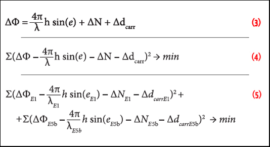 Equations 3, 4 & 5
Working Papers explore the technical and scientific themes that underpin GNSS programs and applications. This regular column is coordinated by Prof. Dr.-Ing. Günter Hein, head of Europe’s Galileo Operations and Evolution.
By Inside GNSS
 FIGURE 1: Proposal to have a single chip GNSS receiver with additional pins to allow for the inclusion of an additional radio
Q: What will limit the spread of multi-frequency GNSS receivers into the mass market?
A: To set the scene, we need to define our terms of reference. By multi-frequency we mean receivers that operate with navigation signals in more than just the standard upper L-band from about 1560–1610 MHz where we find GPS L1, Galileo E1, Compass B1, and GLONASS L1. The obvious additional frequency is the lower L-band, from about 1170 to 1300 MHz, where again the same four constellations have signals.
By Inside GNSS
Navigation users may benefit from GPS modernization sooner than expected thanks to an apparent shift in the schedule of the modernized GPS ground control segment still under development.
The change means that full operational implementation of the new signals will come earlier in the delayed modernization of the operational control Segment (OCS).
By Dee Ann Divis
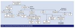 FIGURE 1: Characterization of interference from the user perspective
Increasing demand for ensuring the authenticity of satellite signals and position/velocity/time (PVT) calculations raises the need for tools capable of assessing and testing innovative solutions for verifying GNSS signals and PVT. Today’s civilian systems do not provide authentication at the system level, and a number of mitigation strategies have been developed in the last 10 years at user segment in order to protect receivers from interference and deception.
By Inside GNSS
The world’s four GNSS programs aren’t exactly a classical quartet, weaving Mozart stanzas in disciplined execution.
By Inside GNSS
GPS contractors are scrambling to assess new Pentagon budget-cutting directives that have the potential to slow GPS modernization.
The belt-tightening is in response to a three-way fiscal vise created by the failure of Congress and the White House to agree on a budget for this year, on a new limit for the nation’s debt, and on a plan to implement future budget cuts.
By Inside GNSSNovAtel has announced support for the BeiDou Navigation Satellite System on its OEM6 family and selected OEMStar GNSS receivers.
The long-anticipated BeiDou Interface Control Document (ICD) release is a
significant milestone that facilitates global acceptance of the Chinese
GNSS system into the growing range of satellite-based positioning
applications, the company says.
 Col. William “Bill” Cooley
The U.S. Air Force appears to have identified a future leader of the GPS Directorate.
At a time yet to be determined, Col. William T. "Bill" Cooley will take up the role of Senior Materiel Leader at the Department of Defense (DoD) acquisition office for developing and producing GPS satellites, ground systems, and military user equipment.
By Inside GNSS

Advanced Navigation in collaboration with KVH Industries has announced its new Spatial FOG GNSS/INS, a ruggedized GNSS-aided inertial navigation system and attitude and heading reference system (AHRS).
By Inside GNSS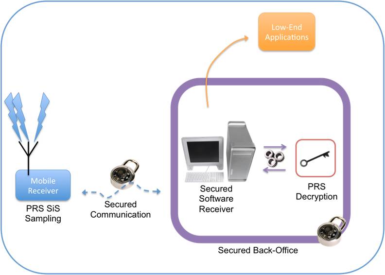 Conceptual design of ULTRA (ultra low-cost PRS receiver)
When European leaders first took up the idea of creating their own GNSS system nearly 20 years ago, they held up the concept of civilian control as a crucial differentiator from existing services operated by national military establishments.
As Galileo nears its operational phase, that principle may manifest itself in a surprising form: the opportunity to offer a range of security-oriented positioning and timing solutions in place of the all-or-nothing alternatives on encrypted services maintained by defense agencies.
By Inside GNSS
The GPS program has taken a fiscal hit that will delay critical plans to begin multi-satellite launches and could ultimately hamper the Air Force’s ability to keep the constellation at its current level of service.
The shortfall is just one of the challenges facing the program over the next four months as the current six-month budget extension winds down, the government’s ability to borrow runs out, and, barring a fast political deal, the onerous budget cuts set up under sequestration kick in.
By Dee Ann Divis

This free workshop on GNSS will take place at the Berjaya Times Square Hotel in Kuala Lumpur, Malaysia on December 8, 9 and 10, 2012.
Registration is limited to the first 100 people. The deadline for registration and abstract submission is November 22.
This is the fourth Asia Oceania Regional Workshop on GNSS. It is organized by Multi-GNSS Asia (MGA), whose aim is to promote GNSS interoperability, development, use and applications in the region.
By Inside GNSS