A: System Categories Archives - Page 177 of 195 - Inside GNSS - Global Navigation Satellite Systems Engineering, Policy, and Design

A: System Categories

May 13, 2009

Ready, Set, Go! The 2009 European Satellite Navigation Competition is open for ideas

Galileo Master’s award winners 2008

Submit the best idea for a brand new satellite navigation application or device and you just might win the 2009 Galileo Master’s Award – €20,000 in prize money and lots of support to make your idea a reality.

But that’s not your only chance – you can try for one of the eight special topic prizes or one of the 17 different regional prizes, together worth €500,000 in cash and start-up assistance.

The competition began six years ago in Bavaria, Germany, but it has expanded to include many other regions of Europe as well as Australia, Israel, and Taiwan.

Read More >

By Inside GNSS
May 5, 2009

GPS SVN49 and L5 Signal: A Success with Problems

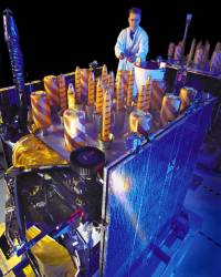
Block IIR-M satellite. Lockheed Martin photo.

Signal anomalies characterized by the U.S. Air Force as “out of family” transmissions will keep the latest GPS satellite from being declared healthy for months, if ever.

The report on space vehicle number (SVN) 49 by the GPS Wing’s chief engineer, Lt. Col. David Goldstein to the European Navigation Conference in Naples, Italy, on May 4 mixed bad news with glad.

Also known as Block IIR-20(M), the spacecraft carries the demonstration payload for the new civil GPS L5 signal. The March 24 launch probably represented the last chance to meet an International Telecommunications Union (ITU) deadline for securing primary rights to use of the RF band by GPS.

Read More >

By Inside GNSS
[uam_ad id="183541"]
April 28, 2009

Obama Lifts Up GPS in Speech to U.S. Scientists

In his April 27 speech to the National Academy of Sciences (NAS) annual meeting, President Barack Obama twice singled out the Global Positioning System as an example of the need for renewing the U.S. commitment to basic scientific research and education.

“The calculations of today’s GPS satellites are based on the equations that Einstein put to paper more than a century ago,” Obama said, having noted that “no one can predict what new applications will be born of basic research. . . .”

Read More >

By Inside GNSS
April 27, 2009

Companies Announce GPS/Wi-Fi Collaboration

Ekahau Inc. has announced that its Wi-Fi location tracking software is being integrated into GPS receivers designed by NavSync Ltd. to enable customers to continuously track asset in indoor and outdoor environments.

Wi-Fi–enabled GPS tag combines NavSync’s NavTrac GPS module with Ekahau’s location protocol. The NavTrac module incorporates the CW85 16-channel GPS receiver/802.11b/g transmitter combination.

Read More >

By Inside GNSS
[uam_ad id="183541"]
April 26, 2009

Loctronix Gains Patent for Its Spectral Compression Positioning, Tracks CDMA, GNSS

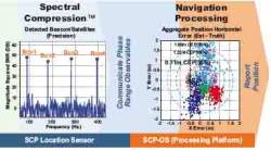
Loctronix SCP technology

[Updated 4/26/09] On March 31, the U.S. Patent Office granted Loctronix Corporation its first patent, which will provide the foundation for its Spectral Compression Positioning (SCP) technology that enables multi-source positioning capability in a single sensor. Subsequently, the company announced that it had successfully achieved meter-level ranging performance using CDMA cellular signals.

Read More >

By Inside GNSS
April 20, 2009

Septentrio Receivers Track L5, Other SVN49 Signals

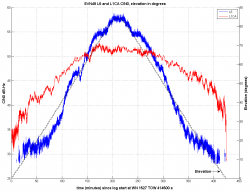
SVN49 L1 C/A (red) and L5 Signals. Septentrio image.

Septentrio reports success in tracking five signals being transmitted from the modernized GPS Block IIR satellite with the L5 demonstration payload launched on March 24.

Now designated space vehicle number 49 (SVN49), the satellite began broadcasting in the L1 and L2 band on March 28, shortly after the spacecraft reached its quasi-circular middle earth sorbit.

Read More >

By Inside GNSS
April 18, 2009

China Launches Second Compass (Beidou-2) Satellite in $1.46 Billion First Phase

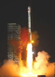
Compass-G2 Launch, April 15, 2009 (Xinhua/Li Gang photo)

Launch of a second modernized Compass (Beidou 2) satellite on April 14 — this one a geostationary spacecraft — marks the return of China to its GNSS launch program two years after the initial venture into space.

Designated Compass G2 — reflecting the geostationary nature of its intended orbital position about 22,300 miles above the equator, the satellite lifted off at 16:16 UTC aboard a Long March 3C rocket from the Xichang launch base in southwestern China’s Sichuan province, according to China’s state news agency Xinhua.

Read More >

By Inside GNSS
IGM_e-news_subscribe