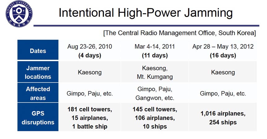
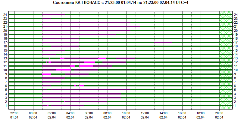
A: System Categories Archives - Page 138 of 199 - Inside GNSS - Global Navigation Satellite Systems Engineering, Policy, and Design

A: System Categories

NovAtel, Interstate Electronics Team on SAASM RTK Receiver Board

NovAtel Inc. today (May 30, 2012) announced the development of their OEM625S Selective Availability/Anti-Spoofing Module (SAASM) GNSS receiver, the first product emerging from a collaborative effort with L-3 Interstate Electronics Corporation (IEC).

The OEM625S, which becomes available for purchase in the third quarter of this year, will combine a commercial dual-frequency NovAtel GNSS receiver with an L-3 IEC XFACTOR SAASM in a single card solution, reducing overall size and power requirements for end customer applications.

Read More >

By Inside GNSS
May 27, 2012

IP Rights and Wrongs

As Desi Arnaz often said to Lucille Ball during an “I Love Lucy” episode on TV, “You’ve got some ’splaining to do.”

I refer, of course, to the untoward and unexpected initiative by the British Ministry of Defense (MoD) to patent the technical innovations that underlie the planned next generation of civil GNSS signals.

Read More >

By Dee Ann Divis
[uam_ad id="183541"]
May 26, 2012

Stanford and Aalborg Announce Summer Workshop on GNSS Positioning for the Future

A number of GNSS experts from the United States, Denmark, Norway and China will lead a weeklong workshop on the future of satellite-based positioning technologies from August 27 through September 2 at the Slettestrand Holiday Center in North Jutland, Denmark.

The topics range from GNSS basics and Intelligent Transportation Systems to new GNSSes, new receivers and indoor navigation as well as environmental monitoring and arctic navigation. The event is organized by Stanford and Aalborg universities.

Read More >

By Inside GNSS

Demystifying GLONASS Inter-Frequency Carrier Phase Biases

EQUATIONS 1 -11

GLONASS currently uses a frequency division multiple access (FDMA) technique to distinguish the signals coming from different satellites in the Russian GNSS constellation. The GLONASS L1 and L2 bands are divided into 14 sub-bands, and each satellite transmits in one of these.

The sub-bands are identified by frequency numbers k, from -7 to 6. The GLONASS L1 and L2 carrier frequencies, in hertz, at a frequency number k are defined by:

Read More >

By Inside GNSS
May 24, 2012

How do GNSS-derived heights differ from other height systems?

FIGURE 2: Example of a national geoid (upper diagram) and a correction surface for the transformation from the new orthometric height system to the old height system (lower diagram). Country is Switzerland. Geoid undulations range from 45 to 55 meters in ETRS89 and from -5 to +5 meters in the national System CH1903+. Lower diagram: Correction surface to transform from the new orthometric height system (LHN95) to the old height system LN02 with corrections from -0.10 to 0.55 meters.

Q: How do GNSS-derived heights differ from other height systems?

A: Height estimation using GNSS always seems to be trickier than horizontal coordinate estimation.

Why?

On the one hand, the GNSS technique has error sources that are more critical in the vertical direction. Height estimates are weaker because of a combination of satellite geometry, the presence of strong correlations to other parameters, such as atmospheric delays, and the antenna phase center model applied during data analysis.

Read More >

By Inside GNSS
[uam_ad id="183541"]

GPS Receiver Specifications

An increasingly urgent call to certify performance of Global Positioning System (GPS) receivers is being heard from several sectors of the national political and business landscape. This issue has arisen now as a direct result of the LightSquared initiative that has generated so much attention over the last 18 months.

Instead of diving into those issues directly, however, a little historical perspective is in order first — and it’s amazing in itself that a technology as new as GPS in the public eye would actually have a history to reflect upon, but it does.

Read More >

By Inside GNSS

Truth on the Range

Typical Rack-Mounted UHARS System

A next-generation “truth” reference system for the U.S. Air Force (USAF) — the Ultra High Accuracy Reference System (UHARS) — is currently under development by the 746th Test Squadron (746 TS) at Holloman Air Force Base, New Mexico.

Read More >

By Inside GNSS

CGSIC: 2012 Civil GPS Interface Committee Meeting

The Civil GPS Interface Committee (CGSIC) will meet during the ION GNSS 2012 conference at the Nashville Convention Center in Tennessee, USA on Monday, September 17 and Tuesday, September 18. This will be the 52nd meeting of the group.

The plenary session on Tuesday morning features updates by the U.S. National Space-Based PNT director, the Air Force GPS Directorate commander,  the Air Force Second Space Operations Squadron commander and State Department and Homeland Security senior officials.

Read More >

By Inside GNSS
May 23, 2012

SpaceX ISS Mission Relies on GPS Technology

SpaceX Falcon 9/Dragon launch on May 22, 2012. NASA/Alan Ault

The unmanned SpaceX Dragon spacecraft currently attempting to visit to the International Space Station (ISS) is using on board GPS receivers to perform a series of maneuvers as part of NASA’s first collaboration with the commercial space operator.

On Tuesday (May 22, 2012) in its first day of flight after launching from Cape Canaveral on board SpaceX’s Falcon 9 rocket, Dragon successfully completed a test of its absolute GPS system, using GPS to determine its location and communicating this data via NASA tracking satellites.

Read More >

By Inside GNSS
IGM_e-news_subscribe