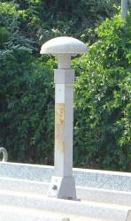
GPS Archives - Page 85 of 138 - Inside GNSS - Global Navigation Satellite Systems Engineering, Policy, and Design

GPS

May 20, 2013

GPS Civil Funding Request Slashed

Jan Brecht-Clark, director, National Coordination Office for Space-Based Positioning, Navigation, and Timing

With just more than four months to go in the 2013 fiscal year, sequestration and furloughs are taking a bite out of key research and the work of the National Coordination Office (NCO) for Space-Based Positioning, Navigation, and Timing (PNT) — the government nexus for GPS-related policy matters.

The NCO is an interagency organization, explained its director, Jan Brecht-Clark in an emailed response; so, “each individual staff member is subject to furloughs implemented by their home agency as a result of sequestration.”

Read More >

By Inside GNSS

ESA Adds System Time Offset to Galileo Navigation Message

The four Galileo in-orbit validation (IOV) satellites now on orbit have begun broadcasting the “offset” between the GPS and Galileo system time, accurate to a few billionths of a second, according to the European Space Agency.

With satellite navigation based around the highly accurate measurement of signal travel times, both Galileo and GPS have their own internal reference time systems used to synchronize all system clocks, including those in the ground segment, on satellites, and in receivers. Galileo System Time is about 50 nanoseconds or less apart from GPS time.

Read More >

By Inside GNSS
[uam_ad id="183541"]

CGSIC Meeting: Civil GPS Service Interface Committee

The 53rd meeting of the Civil GPS Service Interface Committee (CGSIC) will take place on Monday and Tuesday, September 16 and 17 just before the opening of the ION GNSS conference at the Nashville Convention Center in Nashville, Tennessee.

Attendance is free and registration is open at the website below.

The keynote speaker at Tuesday morning’s plenary is a Smithsonian
geographer, Dr. Andrew K. Johnston, who will talk about the museum’s new
permanent exhibit "Time and Navigation: The Untold Story of Getting
from Here.

Read More >

By Inside GNSS
May 16, 2013

Fourth GPS IIF Satellite Launched

GPS IIF-4 logo. United Launch Alliance

The fourth GPS Block IIF satellite, space vehicle number (SVN) 66, was launched successfully today (May 15, 2013) on board a United Launch Alliance Atlas V rocket at 5:38 p.m. EDT from Cape Canaveral Air Force Station, Florida.

It was the first time that an Atlas V had been used to launch a GPS spacecraft.

Read More >

By Inside GNSS
May 13, 2013

White House Moves to Harden Infrastructure against GPS Disruption

System engineers across the country may soon be planning, in some cases perhaps for the first time, what they would do if they could not use the GPS service.

The effort is part of an expanded White House initiative to protect the nation’s critical infrastructure. Alhough infrastructure protection programs have been under way for some time, they did not necessarily address GPS vulnerabilities explicitly.

Read More >

By Inside GNSS
[uam_ad id="183541"]
May 2, 2013

MUSTER

Existing methods for improving the GNSS performance commonly attempt to enhance the signal processing and navigation estimation parts of a single receiver. Such approaches, however, leave unexplored the potential benefits inherent to the integration of data from multiple receivers.

Read More >

By Inside GNSS
April 30, 2013

Air Force Examining Broader Options for Next GPS III Satellite Buy

Gen. William Shelton. DoD photo

The Air Force will decide this fall whether to build more GPS III satellites or move to a new generation of spacecraft, the leader of Air Force Space Command told Congress last week.

“We’re on contract right now . . . through (GPS III) satellite vehicle number eight. Satellite vehicles nine and beyond – the acquisition strategy for that – will be debated in the fall,” General William Shelton, commander of Air Force Space Command (AFSPC), told the House Armed Services Committee on April 25.

Read More >

By Inside GNSS
April 25, 2013

North Korea’s GPS Jamming Prompts South Korea to Endorse Nationwide eLoran System

Projected accuracy and coverage of Korea’s eLoran network. Ministry of Oceans and Fisheries of Korea

GPS jamming attacks from North Korea that have increased in frequency and duration since they began August 2010 have prompted the South Korean government to implement an enhanced Loran (eLoran) systems that will cover the entire country by 2016.

The South Korean government completed design, development, and construction documents for the eLoran system in February and will procure the system infrastructure through international competitive bidding.

Read More >

By Inside GNSS
1 83 84 85 86 87 138
IGM_e-news_subscribe