May 11, 2024
Weekend Read: Strong Geomagnetic Storms May Impact GNSS
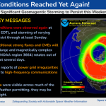
The NOAA Space Weather Prediction Center in Boulder, CO has updated its Geomagnetic Storm Warning for the weekend of May 10 – May 12, 2024. “Significant geomagnetic storming to persist this weekend”, the warning states. “There have been reports of power grid irregularities and degradation to high-frequency communications and GPS”. Aurora effects in the sky were observed as far south as Alabama and Florida.
By Inside GNSS