
SouthPAN calling OEMs to take part in survey to integrate SBAS precise positioning down under.

The Australian and New Zealand governments, with support from FrontierSI, are conducting a survey with Original Equipment Manufacturers (OEMs) to understand the opportunities and barriers for integrating SouthPAN signal support in your GNSS chips, devices and equipment.
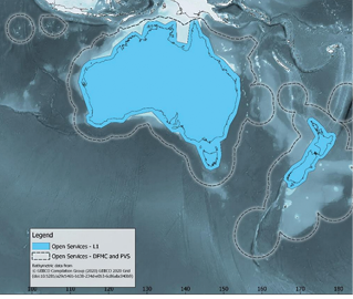
SouthPAN is the first Satellite-Based Augmentation System (SBAS) in the Southern Hemisphere and provides improved positioning and navigation services in Australia, New Zealand and maritime regions. Depending on the device, precise positioning from SouthPAN will offer improved accuracies down to as little as 10 centimeters. SouthPAN provides augmented and corrected satellite navigation signals directly from the satellite rather than through a mobile phone, providing accuracy that overcomes gaps in mobile internet and radio communications.
SouthPAN early Open Services have been live since September 2022, with aviation safety-of-life certified SouthPAN services planned in 2028. Safety-of-life certified services will support end users engaging in operations where life can be at risk, like landing an aircraft at an airport. SouthPAN is bringing next-generation SBAS to Australia and New Zealand, creating new market opportunities for OEMs and end-users. An independent economic benefits analysis estimated SouthPAN will provide more than $AUD 7.6 billion of benefits for Australia and New Zealand over 30 years.
As an OEM of equipment providing positioning and/or navigation services, we would value your insights on the support of SouthPAN’s three services into chips, devices and equipment. In particular, we would be keen to hear your views on barriers and opportunities for support of the L1, Dual Frequency Multi-constellation (DFMC) and Precise Point Positioning Via SouthPAN (PVS) services.
The information you provide will assist Geoscience Australia (GA) and Toitū Te Whenua Land Information New Zealand (LINZ) to understand your needs and realize the full potential and benefits offered by SouthPAN. Information about SouthPAN compatibility will be published on GA and LINZ websites to help end-users identify what GNSS devices can access SouthPAN signals. All other information will be aggregated so no individual or business information is identified. The survey should take approximately 10 minutes. If you would like to speak with us about SouthPAN, the survey, or other opportunities, please contact so******@************om.au.
We are seeking your expertise and input into the opportunities and barriers to integrate SouthPAN precise positioning by September 30.
Images courtesy of Geoscience Australia.


