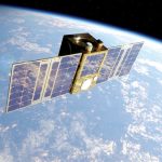

As LEO PNT matures, the discussion is shifting from: “can LEO produce a PNT solution?” to “what must happen before users trust it?”
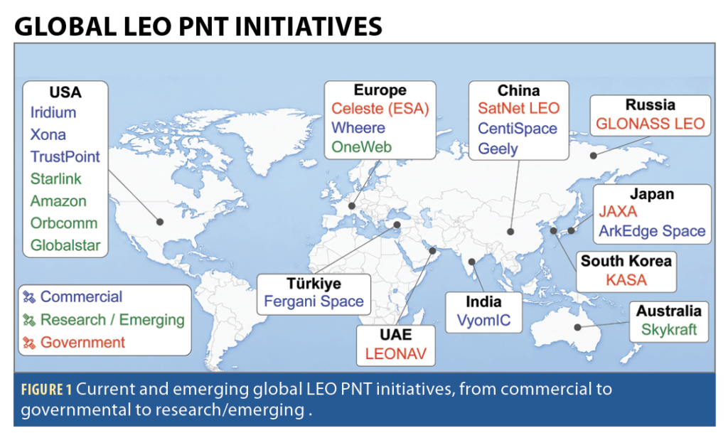
An unusual thing is happening in the navigation community. Almost everyone now believes in low Earth orbit positioning, navigation and timing (LEO PNT). Governments are studying it. Startups are building it. Researchers are publishing it. Investors are funding it. Satellite operators are discussing it (Figure 1). Even the GNSS community, historically cautious about claims of disruption, increasingly accepts that LEO will play some role in the future of PNT.
For years, the central challenge surrounding LEO PNT was whether it could work. Today, that challenge is increasingly getting addressed. Dedicated LEO constellations have transmitted navigation signals from orbit. Opportunistic approaches have demonstrated PNT with signals never intended for navigation. Governments have initiated national LEO PNT programs, while commercial companies are investing billions of dollars in satellite infrastructure that may ultimately support PNT.
LEO PNT is entering an uncomfortable phase of maturity. The debates are shifting from technical to operational. Can LEO PNT be trusted? Can it scale? Can it integrate? Can it survive commercially? Can it become infrastructure? What role will it play? Who will pay for it? And perhaps most importantly, what problem is it actually solving?
The questions are shifting from “Can LEO PNT work?” to “Can LEO PNT become trusted infrastructure?” The answers depend, in part, on which vision of LEO PNT one adopts.
As discussed in last issue’s column, LEO PNT: Why Now?, four schools of thought have emerged: dedicated, dual-purposed, augmented and opportunistic LEO PNT. Each starts from a different premise about what problem LEO should solve and how it should fit into the broader PNT ecosystem.
Dedicated providers such as Xona, TrustPoint, Centispace and others are building navigation-first systems. Dual-purposed systems such as Iridium combine communications and PNT. Augmented architectures, exemplified by ESA’s Celeste vision, view LEO as an additional layer that complements GNSS. Opportunistic approaches exploit them all. Anything that can be tracked is fair game—it becomes a potential navigation source.
Although these four approaches differ substantially in architecture, economics and operational assumptions, they ultimately encounter the same three questions.
QUESTION 1: How Close are We to Operational LEO PNT?
This may be the most misunderstood question in the field. The answer depends on which school of thought you examine.
A dedicated constellation, a dual-purposed communications system, an augmented GNSS architecture, and an opportunistic navigation system do not become operational in the same way. Each follows a different path from demonstration to utility, and each encounters different technical, economic and operational challenges along the way.
This distinction is important because discussions of LEO PNT often treat the field as if it was a single technology moving toward a common destination. In reality, the various LEO PNT approaches may be solving different problems, serving different users, and operating under different definitions of success.
Dedicated systems are transitioning from demonstration to infrastructure. They arguably face the most difficult transition because they must simultaneously build a constellation, a timing architecture, a monitoring network, a receiver ecosystem, and a customer base. Launching satellites is difficult. Building infrastructure that users trust for decades may prove even harder.
Some dual-purposed systems are already operational. Ironically, the school closest to operational maturity may not be the dedicated providers that receive the greatest attention. Iridium PNT already operates from an existing communications infrastructure and currently represents the most mature example of operational LEO PNT. The space segment exists. The ground segment exists. The satellites have demonstrated years of operation. The challenge is, therefore, less about deployment and more about expanding capability.
Augmented systems may face the lowest adoption barrier because they do not need to displace GNSS. Their value proposition is incremental rather than revolutionary. If a LEO layer improves availability, shortens precise point positioning (PPP) convergence, strengthens resilience, or improves urban performance, then it can justify deployment without ever becoming a standalone navigation system.
Opportunistic systems are another beast, presenting a different definition of operational. What does it mean for a navigation system to become operational when the underlying infrastructure belongs to someone else? In one sense, opportunistic systems are already operational because the satellites, signals and user communities already exist. In another sense, they remain developmental because the navigation capability depends on extracting observables from infrastructures whose operators make no formal navigation commitments.
Despite their differences, all four schools eventually encounter the same challenge. Demonstrations answer whether navigation is possible. Operational services answer whether navigation can be trusted.
A single satellite can demonstrate ranging. A handful of satellites can demonstrate positioning. A constellation can demonstrate coverage. But infrastructure requires something more. We should stop asking whether satellites have launched. Instead, we should ask whether orbit determination is operational, whether time synchronization is operational, whether monitoring and integrity frameworks are operational, whether continuity targets are being met, and whether performance commitments are backed by demonstrated capability.
The greatest risk facing many LEO PNT initiatives may no longer be technical failure. It may be the assumption that technical success automatically leads to operational adoption.
QUESTION 2: What Can One Satellite or a Small Constellation Contribute?
One of the most common misconceptions surrounding LEO PNT is that value emerges only after a constellation achieves continuous global coverage.
History suggests otherwise. Some in the navigation community often think in binary terms. A system is either operational or it is not. A constellation either provides continuous positioning or it does not. Yet, many of the most important capabilities emerge long before full operational capability is reached.
This is not unique to LEO PNT. GPS itself began creating value well before the constellation reached full operational capability. The same was true for communications constellations, Earth observation systems, and timing infrastructures. Early deployments rarely deliver the final service. Instead, they reveal which capabilities become useful first.
A single LEO satellite cannot provide continuous global positioning. That much is obvious. What is less obvious is how much useful information a single satellite can provide. At the most basic level, a single satellite can support timing-transfer experiments, receiver development, orbit and clock estimation validation, signal authentication concepts, and resilience demonstrations. More interestingly, the high dynamics of LEO satellites create large Doppler frequency that can become valuable navigation measurements. Long before a constellation can provide continuous and instantaneous positioning, it can contribute observability.
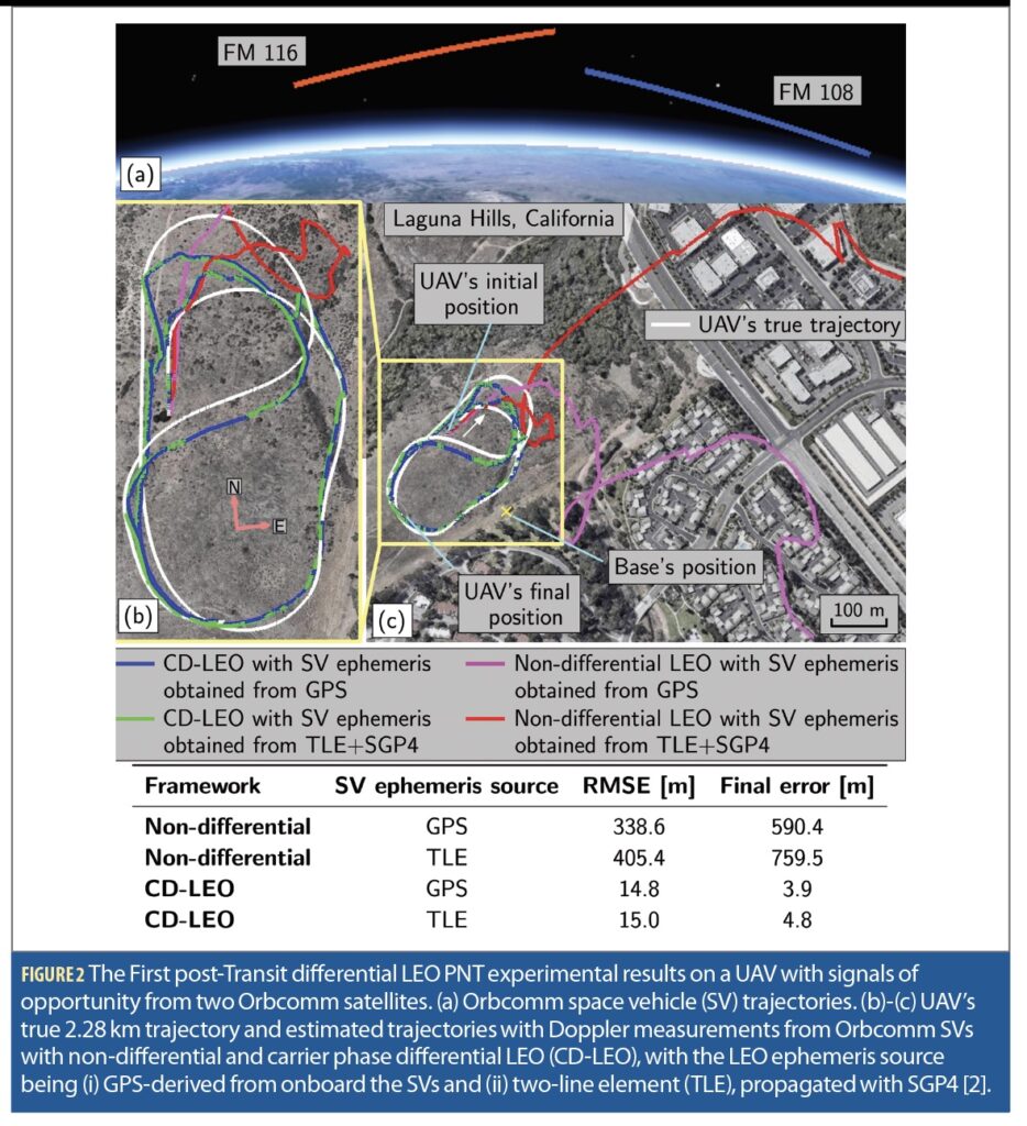
This observation is particularly important for opportunistic LEO PNT. The earliest post-Transit demonstrations with Orbcomm did not rely on dedicated navigation signals [1]. They relied on extracting useful navigation information from sparse, non-cooperative communications signals [2]. The positioning performance was limited, but the demonstrations established something far more important: navigation observables could exist even when navigation services did not (Figure 2).
That distinction continues to shape opportunistic LEO PNT today. A Starlink or OneWeb signal does not necessarily need to become a navigation service to create navigation value [3],[4]. If the signal provides useful Doppler, timing, carrier-phase, or ranging information, it can contribute to a navigation solution even when the constellation operator has made no formal commitment to navigation [5],[6]. In this sense, opportunistic systems may not be trying to become navigation infrastructure. They may instead become sources of observability that strengthen broader PNT architectures.
As additional satellites are added, the value increases considerably. Not necessarily because the system suddenly becomes a GPS replacement, but because it becomes a powerful augmenter. Several emerging architectures suggest that even modest LEO deployments can improve positioning performance when combined with GNSS. Benefits may include faster PPP convergence, improved velocity estimation, enhanced measurement diversity, increased resilience to GNSS disruptions, and improved performance in challenging urban environments where traditional satellite geometries are degraded.
This point is worth emphasizing. Many discussions implicitly assume LEO PNT must eventually replace GNSS to justify its existence. Yet, some of the strongest value propositions emerge when LEO and GNSS work together. The bar for becoming useful is much lower than the bar for becoming a global standalone navigation system.
In fact, timing users may become significant beneficiaries before positioning users. A positioning solution generally requires multiple observations. Timing applications often require less. For telecommunications networks, financial infrastructure, power grids, and data centers, the value proposition may not be a position solution at all. It may be access to an additional timing reference capable of constraining oscillator drift, improving holdover performance, or providing an independent source of synchronization. This possibility receives less attention than positioning, but it could prove commercially important. Some users may be willing to adopt LEO-derived timing services long before continuous global positioning services become available.
The implications differ across the four schools of thought. For dedicated systems, early satellites provide opportunities to validate signals, timing architectures, user equipment, and operational concepts. For dual-purposed systems, they demonstrate how navigation can leverage existing communications infrastructure. For augmented architectures, even limited deployments may improve GNSS performance and resilience. For opportunistic systems, the first satellites are often enough to demonstrate the central premise that useful navigation information can be extracted from signals that were never designed for navigation in the first place.
The broader lesson is that constellations should not be judged exclusively on their ability to provide continuous positioning. They should also be judged on the value they create before continuous positioning becomes possible. A navigation service may require hundreds of satellites. A useful capability often requires far fewer.
QUESTION 3: What Must Happen Before Users Trust LEO PNT?
This is arguably the most difficult question facing the LEO PNT industry.
The navigation community often speaks about accuracy. Many users, especially in safety-critical systems, care just as much about trust.
A navigation solution can be extraordinarily accurate and still be unsuitable for operational use if users do not understand when it is wrong. In fact, one of the defining characteristics of navigation infrastructure is not that it always performs well. It is that users understand how well it is performing, when it is degraded, and when it should not be trusted.
Trust begins with signals. But it does not end there. Much of the public discussion surrounding LEO PNT focuses on waveforms, frequencies, signal power, and receiver sensitivity. These are important topics. Yet, navigation systems are not built on signals alone. Every satellite navigation solution depends fundamentally on three things: signal, satellite orbit and satellite clock.
Signals create measurements. Orbit and clock knowledge create meaning. A receiver must know where the satellite was when a signal was transmitted. A receiver must know what time the satellite thought it was. Without both, ranging becomes geometry without a reference.
This reality is particularly important in LEO. Unlike GNSS satellites residing in medium Earth orbit (MEO), LEO satellites experience significant atmospheric drag, more dynamic orbital environments, and rapidly evolving states. Orbital maneuvers will get more frequent and severe as LEO becomes more congested. Orbit determination is, therefore, not merely a technical detail. It is a foundational requirement for navigation performance.
The same is true for timing. Traditional GNSS achieves remarkable timing performance through sophisticated atomic clocks supported by extensive control infrastructures developed over decades. Most emerging LEO providers are pursuing different approaches. Some rely heavily on GNSS-derived synchronization. Others emphasize ground synchronization networks, optical inter-satellite links, distributed timing architectures, miniaturized atomic clocks, or combinations thereof. Each approach represents a different answer to a fundamental question: How does a LEO constellation know what time it is? That question may ultimately prove as important as signal design itself.
Yet, even orbit and clock knowledge are only part of the trust equation. Evolving a demonstration to a service hinges on monitoring. A demonstration shows that a navigation solution can be produced. A service continuously evaluates whether that solution should be trusted. This distinction is often overlooked. Users frequently focus on positioning performance while paying less attention to monitoring infrastructure, anomaly detection, fault isolation, and quality assurance. Operational systems cannot afford such a luxury. The question is not whether a system works on a good day. The question is whether the system knows when it is having a bad day.
This is where integrity enters the discussion. Integrity is one of the most frequently used but least appreciated concepts in navigation. At its core, integrity addresses a simple question: Can the system detect and communicate when it should not be trusted?
For many applications, this question matters more than another meter of positioning accuracy. A highly accurate solution whose failures are invisible may be less valuable than a less accurate solution whose limitations are clearly understood. Integrity becomes particularly important as LEO PNT moves beyond demonstrations and into operational applications. Autonomous systems, critical infrastructure operators, timing users, aviation stakeholders, and defense users all require more than position estimates. They require confidence estimates. They need to know not only where they are, but how much they should trust where they are.
Closely related is continuity. Continuity turns a technical capability into infrastructure. A navigation demonstration may succeed one day, one week, or one month at a time. Infrastructure must succeed continuously. Satellites must be monitored. Clocks must remain synchronized. Orbit products must remain accurate. Service disruptions must be detected and managed.
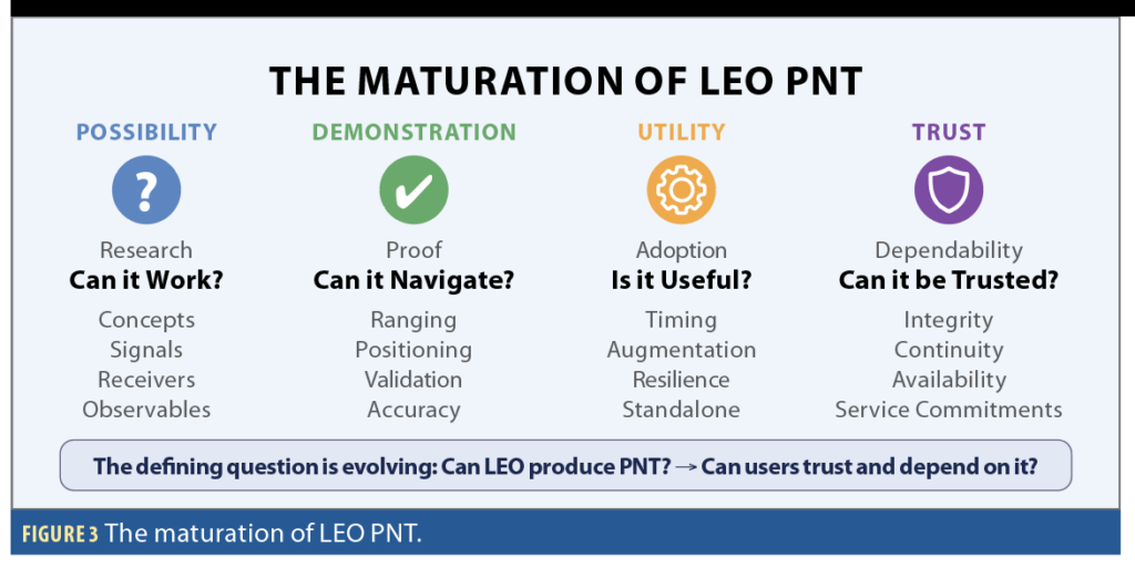
This is one reason the path from demonstration to utility is often much longer than the path from concept to demonstration. The transition is not simply about launching more satellites. It is about institutionalizing trust (Figure 3).
When evaluating emerging LEO PNT systems, we should ask questions that receive far less attention than launch announcements:
• How are satellite orbits determined?
• How are clocks synchronized?
• How is integrity quantified?
• How are anomalies detected?
• How quickly are users alerted?
• What continuity targets are being met?
• What performance commitments are being made?
These questions may seem mundane compared with new signals, new satellite, and new constellation announcements. In reality, they are far more important. History suggests that navigation systems succeed not because they occasionally perform well, but because users know when they can trust them. Or, perhaps more importantly, when they cannot.
From Possibility to Infrastructure
The first era of LEO PNT asked whether navigation from LEO was possible. The second era asked whether useful observables could be extracted from dedicated and non-dedicated signals. The third era, the one we’re entering now, is asking something much harder: Can LEO PNT become trusted infrastructure?
That question extends far beyond satellites. It encompasses trust, integrity, timing, monitoring, economics, standards, governance, receiver ecosystems, and business continuity. Dedicated systems must prove they can scale. Dual-purpose systems must prove they can prioritize navigation when needed. Augmented systems must prove they add measurable value. Opportunistic systems must prove they can deliver robust performance despite relying on infrastructures they do not control.
The most interesting question in LEO PNT is therefore no longer: Can it work? The most interesting question is becoming: What must happen before users trust it?
The answer to that question will determine whether LEO PNT becomes a niche technology, a valuable augmentation layer, or one of the foundational pillars of the next generation PNT ecosystem.
References
(1) J. Khalife and Z. Kassas, “Receiver design for Doppler positioning with LEO satellites,” IEEE International Conference on Acoustics, Speech, and Signal Processing, May 12-17, 2019, Brighton, UK, pp. 5506-5510.
(2) J. Khalife, M. Neinavaie, and Z. Kassas, “Navigation with differential carrier phase measurements from megaconstellation LEO satellites,” IEEE/ION Position, Location, and Navigation Symposium, Apr. 22-24, 2020, pp. 1393-1404
(3) Z. Kassas, M. Neinavaie, J. Khalife, N. Khairallah, S. Kozhaya, J. Haidar-Ahmad, and Z. Shadram, Enter LEO on the GNSS stage: navigation with Starlink satellites, Inside GNSS Magazine, Vol. 16, Issue 6, Dec. 2021, pp. 42-51.
(4) Z. Kassas, S. Kozhaya, J. Saroufim, H. Kanj, and S. Hayek, “A look at the stars: navigation with multi-constellation LEO satellite signals of opportunity,” Inside GNSS Magazine, Vol. 18, Issue 4, Aug. 2023, pp. 38-47.
(5) S. Kozhaya, J. Saroufim, and Z. Kassas, “Unveiling Starlink for PNT,” NAVIGATION, Journal of the Institute of Navigation, 2025, Vol. 72, no. 1, pp. 1-35.
(6) S. Kozhaya and Z. Kassas, “A first look at the OneWeb LEO constellation: beacons, beams, and positioning,” IEEE Transactions on Aerospace and Electronic Systems, 2024, Vol. 60, no. 5, pp. 7528-7534.