This has been a productive year so far for Australia in terms of GPS breakthroughs, but plans are in place for the country to continue to make big strides in GPS technology and precise positioning programs.
Spatial Source — Australia and New Zealand’s first website covering the geospatial, surveying, GIS and mapping communities — reports that Australia officially has its first GPS infrastructure in space, according to the nation’s Minister for Defence Industry Christopher Pyne.
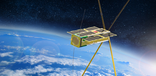
A four-kilogram, U.S,-developed Biarri-Point cubesat was launched as part of the QB50 constellation in April 2017 towards the International Space Station (ISS), alongside three other Australian research cubesats.
Biarri-Point was deployed in May from the ISS into its own low Earth orbit (LEO), carrying the Namaru GPS technology — the first fully Australian and New Zealand GPS payload for a cube-satellite. According to Spatial Source, Minister Pyne said Biarri-Point is now successfully transmitting its findings back to Earth.
The Biarri project is a four-nation defense-related project involving Australia, the U.S., the UK and Canada. The Biarri-Point miniature satellite is the first of four Biarri cubesats to be deployed in the effort to learn more about cubesat formation flying and the drag and lift forces affecting signals from cubesats. The expectation is to inform future applications of satellite positioning with GNSS, including for future high precision satellite-based augmentation system (SBAS) and precise point positioning (PPP) capabilities, as well possible defense applications.
The Namuru GPS technology is on-orbit and is successfully functioning correctly providing significant research benefits, according to Minister Pyne.
“It is conducting a range of experiments aimed at increasing our understanding of outer atmospheric effects on small satellites and improving our situational awareness of space,” he said on the Spatial Source website.
Biarri-Point is equipped with a L1 signal GPS receiver designed to measure the precise relative position of the Cubesats in its LEO. The spacecraft is also fitted with corner reflectors, thereby allowing the satellites to also be located using satellite laser ranging (SLR).
The U.S.-built satellite carries a GPS technology payload, which was developed by the University of New South Wales (UNSW), Sydney, and Defence Science and Technology (DST) Group. UNSW has signed a contract with the Australian Government’s Defence Science and Technology (DST) to provide on-going support for the Namuru V32R3 GPS receivers.
Minister Pyne states the success of the Biarri-Point marks an important milestone for Australia’s space and defense capabilities. In June this year, Australia’s federal government announced that AU$500 million (about $396.8 million U.S.) will be put towards improving Australia’s space-based intelligence, surveillance and reconnaissance capabilities for defense and commerce.
Three additional Biarri satellites are set to be launched either later this year or in 2018.
Australia’s Space Industry
Earlier this month, the Australian Government announced it will review the nation’s space industry capability to develop a long-term plan for big growth.
The Minister for Industry, Innovation and Science, Arthur Sinodinos said the aim is to “develop a long-term plan to grow this important and exciting sector” and report in March 2018.
He added that the space industry sector has been growing at a compound annual growth rate of 9.52 percent from 1998 to 2015, more than three times the annual growth rate of world GDP in the same period. Globally, revenue from space-related activities in 2015 was about $323 billion (U.S. dollars).
In other reports, it was suggested the timing is right for the establishment of an Australian space agency, another sign that the country is primed to play a bigger role.
More Breakthroughs for Australia
Earlier this year Geoscience Australia, an agency of the Commonwealth of Australia, and Lockheed Martin announced they had entered into a collaborative research project to show how augmenting signals from multiple GNSS constellations can enhance positioning, navigation, and timing for a range of applications. GNSS signals are critical tools for industries requiring exact precision and high confidence, and this new testbed will demonstrate enhanced navigation performance for nine critical industrial sectors in Australia.
Additionally, came news that the Australian Government will be collaborating with New Zealand on the project to improve positioning capability in the Australasia region.
The Australian government’s announcement in January that it would invest $12 million in a two-year program looking into the future of positioning technology in Australia was followed by plans for testing of satellite-based augmentation systems (SBAS) to be undertaken, and for future applications for all four major modes of transport in Australia, as well as for potential safety, productivity, efficiency and environmental benefits.


