A recent spoofing and jamming incident at the LA/Long Beach VTIS shows this growing threat isn’t just a problem in conflict zones.
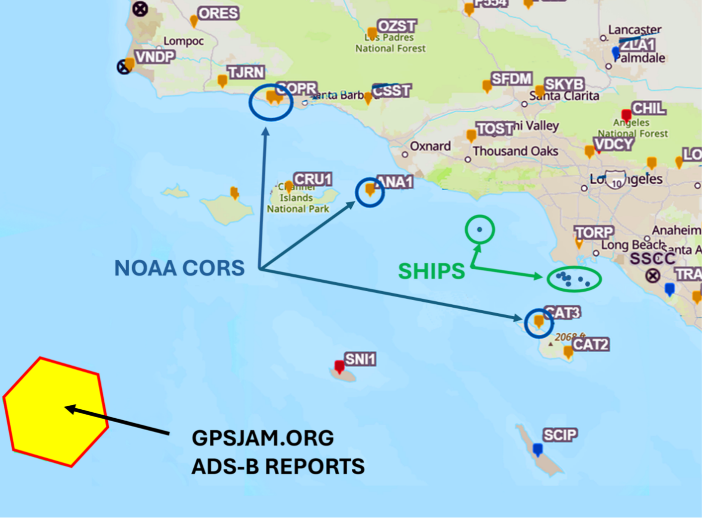
It’s late at night, January 29, 2026. Most of Southern California is asleep. Ships approaching Long Beach harbor from the West key their mics on VHF channel 14 and report GNSS outages to LA/Long Beach Vessel Traffic Service (VTIS). Aircraft over the Channel Islands squawk the same via ADS-B. NOAA Continuously Operating Reference Station (CORS) sites record anomalies in L1 and L2 signal-to-noise ratios. All of this within an hour.
While spoofing and jamming of GNSS have been recurring issues in conflict zones, incidents like this show no one is immune.
Maritime Impacts
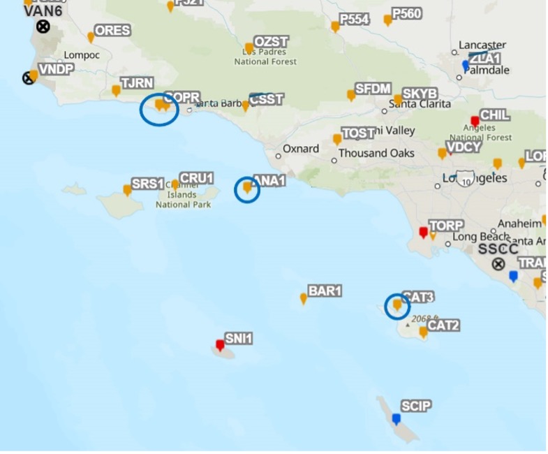
Automatic Identification System (AIS) reports from at least 7 vessels indicate position jumps indicative of spoofing. At least one vessel’s AIS system ceased transmitting altogether for nearly an hour, likely due to an invalid GNSS solution. Data indicates this event covered greater than a 100-mile area, including the critical LA/Long Beach Traffic Separation Scheme.
All of the documented GNSS anomalies occurred within one hour, but the most dramatic position jumps shown by AIS messages lasted only several minutes. The short duration of the event is the only factor that prevented greater impact on PNT and limited public awareness of the event.
All of the reported interference occurred between 11 p.m. and midnight local time, with good visibility and no inclement weather, and all the vessels involved entered port without incident. But, it should be noted that several of the vessels were navigating in close proximity to one another in the vessel traffic separation scheme, and loss of valid GNSS solution could impact situational awareness and create distraction at a critical point in their voyages.
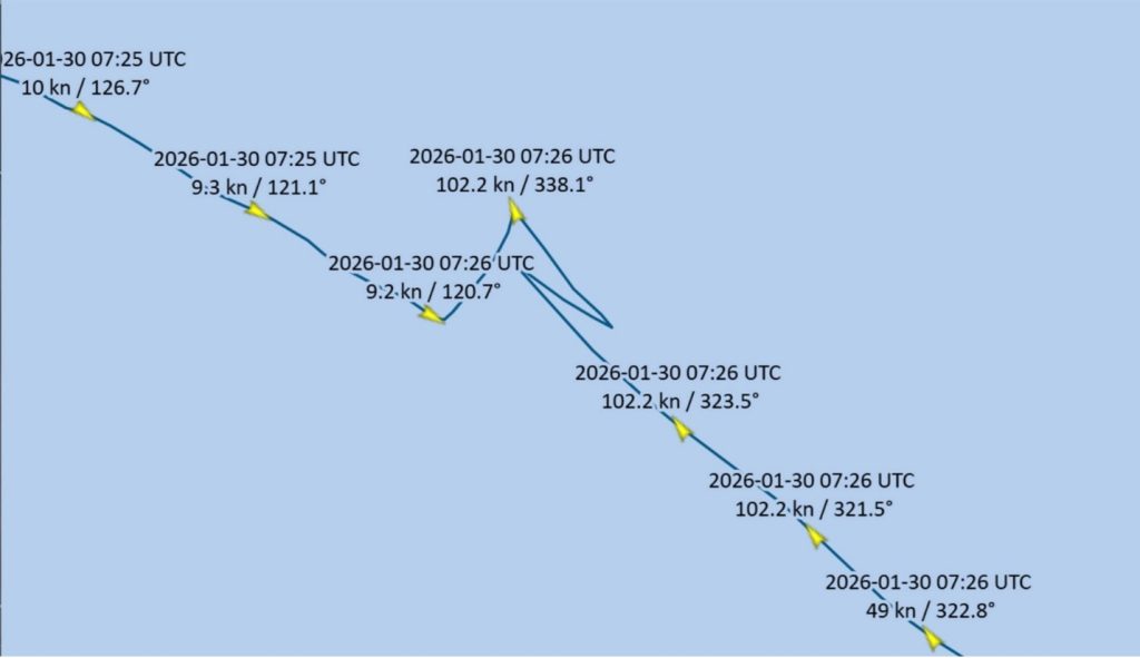
Figure 2 shows the AIS track of a large container ship showing position jumps resulting in invalid, erratic course and speed over ground:
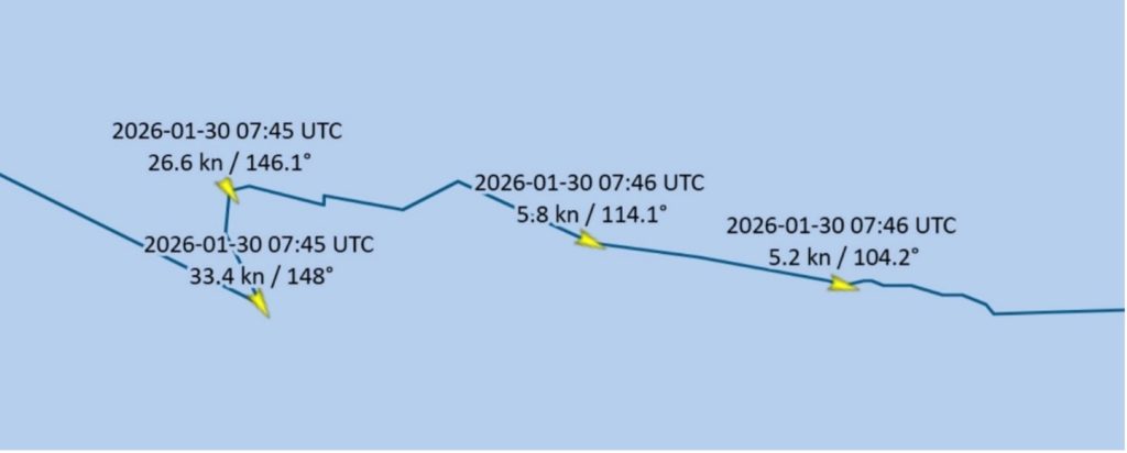
A tanker experienced similar position jumps:
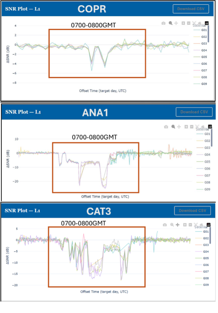
In addition to AIS vessel reports, which typically are transmitted at about 10 second intervals while underway, three local NOAA CORS sites recorded Signal-to-Noise Ratio (SNR) anomalies in the same hour:
Figure 4
Aviation Affected
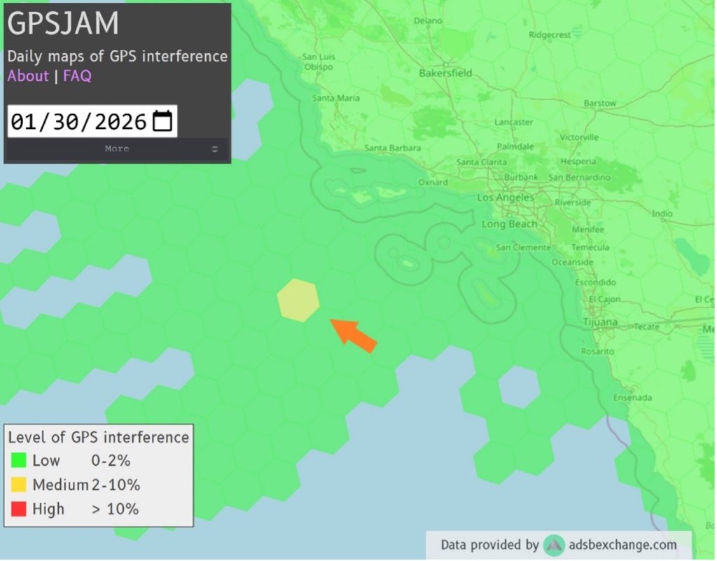
Additionally, the GPSjam.org website showed aircraft evidence (ADS-B messages) of GNSS anomalies much further to the southwest of the reporting commercial ships, indicating the interference may have covered a far larger area than AIS data indicates.
Figure 5
The Source
On February 4, six days after the event, the minutes of the L.A./Long Beach Harbor Safety Committee meeting recorded:
“GPS Outages: On the evening of January 29, VTS LA-LB received multiple reports of GPS outages from vessels in the LA-LB AOR. Sector personnel, with support from our port partners and the Coast Guard Navigation Center, were able to identify a GPS testing event as the likely cause. While there were no incidents or negative impacts due to the outages, the Coast Guard continues to investigate the outages and will take action to prevent recurrence.”
While GPS testing is a regular occurrence, interference like that of Jan 29, 2026, is quite rare.
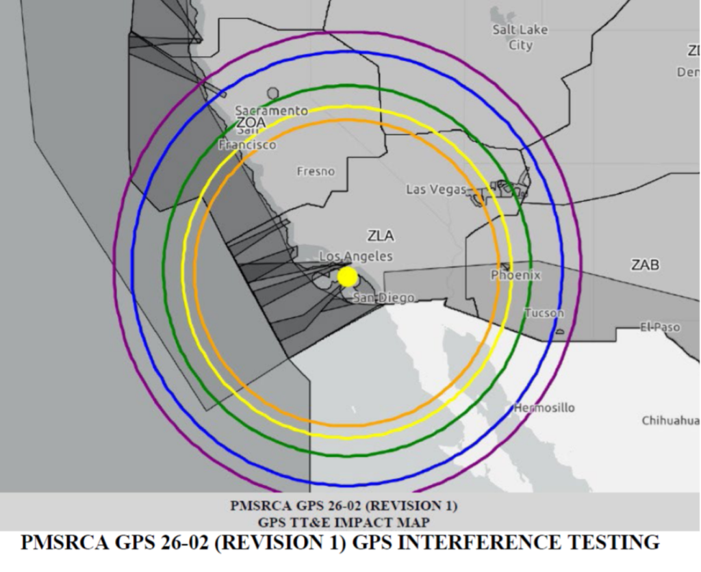
The available data does not provide certainty, but the most likely source of these anomalies was a GPS test dubbed PMSRCA 26-02, that is, Point Mugu Sea Range California 26-02.
An FAA Notices to Airmen (NOTAMs) released on January 22, 2026. states:
“GPS testing is scheduled as follows and may result in unreliable or unavailable GPS signal.”
A. Centered at 332451N1183430W or the SXC VOR 272-degree radial at 8 NM.
(near Catalina Island)
B. Dates and times (Dates and times are based on GMT (Z).):
27 – 31 JAN 26 DLY 0700Z – 1400Z (event occurred 30 Jan 0700Z – 0800Z)
D. NOTAM INFO: NAV GPS (PMSRCA GPS 26-02) (INCLUDING WAAS, GBAS, AND ADS-B) MAY NOT BE AVBL WI A 452NM RADIUS CENTERED AT 332451N1183430W (SXC272008) FL400-UNL,
…and included this graphic (Figure 6):
While NOTAMs alert aviation, the U.S. Coast Guard Navigation Center (NAVCEN) website publishes monthly schedules of GPS testing for mariners. However, PMSRCA 26-02 was not listed on the January schedule, but did appear on the February GPS testing schedule released on February 13, 2026, about two weeks after the January 29 jamming and spoofing instances.
Even though the NAVCEN website may not have published notification of that particular GPS test in a timely manner, GPS anomalies are so infrequent in the Americas that few mariners would likely have been alerted. The unfortunate reality is the United States, unlike China, Russia, South Korea, the United Kingdom, Saudi Arabia and India, has not established a viable alternate PNT system.
When GPS/GNSS is unreliable or unavailable, AIS goes down with it, or, even worse, will transmit and receive spoofed position, courses and speeds. Until an alternative PNT system to backup GNSS is a reality, the only option is to defend GNSS against jamming and spoofing. There are technologies with such capabilities, but they have yet to be embraced by the shipping industry. That risk-reward calculation may change if GNSS reliability continues to erode not only in conflict zones, but other parts of the globe as well. We may be entering new frontiers in electronic warfare as recent reports of space-based interference could raise the stakes for PNT users across the globe.
Authors
Captain James Haley is a senior consultant for UHU Technologies. He served for 32 years as a harbor pilot and navigation technology expert in Long Beach, Calif.
Captain Dana A. Goward is President of the Resilient Navigation and Timing Foundation. He retired from the Senior Executive Service and served as the maritime navigation authority for the U.S.


