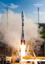
With designs on providing a boost to navigation safety and efficiency for commercial and general aviation, Raytheon Company on May 18 launched its GEO 6 satellite payload into orbit for its 12-year mission. It is the latest payload to support the Federal Aviation Administration’s Wide Area Augmentation System (WAAS) which enhances the reliability and accuracy of GPS signals for directing air travel.
With designs on providing a boost to navigation safety and efficiency for commercial and general aviation, Raytheon Company on May 18 launched its GEO 6 satellite payload into orbit for its 12-year mission. It is the latest payload to support the Federal Aviation Administration’s Wide Area Augmentation System (WAAS) which enhances the reliability and accuracy of GPS signals for directing air travel.
The Raytheon-developed payload is a key element of the WAAS System, which offers commercial, business, and general aviation pilots more direct flight paths, greater runway capability and precision approaches to airports and remote landing sites without dependence on local ground-based landing systems.
“This latest payload launch is the next step in our journey with the FAA to bolster navigation safety and efficiency for commercial and general aviation,” said Bob Delorge, vice president Transportation and Support Services, Raytheon Intelligence, Information and Services.
In June 2016, Raytheon launched WAAS GEO 5 which was recently accepted by the FAA for integration into the operational WAAS system. Both WAAS GEO 5 and GEO 6 were launched to replace aging satellites and enhance GPS precision for the FAA. WAAS increases GPS accuracy from 10 meters to approximately two meters and supports nearly all of the national airspace.
“It’s a refresh. As you know satellites have a life expectancy so this is in the normal cycle,” Delorge told Inside GNSS. “Plus, we have a parallel program called dual frequency, or what we call WAAS DFO. This will bring in some capability from that satellite to help refine the activity. That’s the benefit of, ‘A’, a new system in the air, and also there will be some added enhancements based on a parallel program we’ve got going.”
The WAAS GEO 6 payload is hosted on a geostationary satellite, SES-15, owned and operated by SES. The satellite was successfully launched from Arianespace’s Guiana Space Center in French Guiana aboard a Soyuz launch vehicle. The SES-15 and the WAAS GEO 6 payload will be stationed at 129 degrees longitude west.
“What’s important for us is that it supports the coverage range that the FAA was looking for,” Delorge said. “When it’s in its final orbit it will be at 129 west so we’re well within the FAA’s coverage range. What’s important about that is it gives us full continental U.S. as well as Alaska and Hawaii coverage.”
Delorge said the GEO 6 payload is just a “relatively small piece of the payload” on board the satellite. He added that Raytheon is working with the FAA in the hopes of securing a contract next year for GEO 7 as a continuation of the FAA’s overall program to refresh satellites.
The latest launch gives the company an opportunity to showcase a project that has been in the works for some time, with much of the research and development taking place at Raytheon’s California facility.
“When you have something like this that is very public, very open, there’s a lot of pride that comes with it,” Delorge said. “I know the team’s excited. Most of this work happens at our Fullerton, California site, and these are big milestones that teams have worked for years to get in place.”
He added that while Raytheon is well known for its military work, projects like the GEO 6 launch help the company “build on the strength of its overall GPS capabilities.”
“Assuming you have an all-weather position navigation system, this is working with the FAA to allow for a safe, efficient air traffic air flow in the future,” Delorge added.
In other news involving Raytheon, Inside GNSS reported last month on baselining of the Next Generation Operational Control System or OCX program.
In the article, “OCX Passes Deep Dive Review; GAO Says Program Risk Remains High” updates are provided on the completion of the re-baselining of the OCX program, of which Raytheon is the prime contractor.


