Like some behemoth rocket ship launched in the 1970s, the Global Positioning System sails on through an expanding universe of users and applications, seemingly imperturbable, successful beyond the expectations of its creators, an enormous momentum carrying it into the third millennium.
Like some behemoth rocket ship launched in the 1970s, the Global Positioning System sails on through an expanding universe of users and applications, seemingly imperturbable, successful beyond the expectations of its creators, an enormous momentum carrying it into the third millennium.
To all appearances, GPS is prospering more than ever: a second full signal (L2C) is becoming available to civil and commercial users, a denser ground monitoring system being built out, improved accuracies squeezed out of the algorithms and operational practices at the Master Control Station in Schriever Air Force Base, prices dropping on products with more features and functions than ever, hundreds of millions of receivers in use around the world. A follow-on generation (Block IIF) of satellites with a third civil signal (at the so-called L5 frequency) is being built by Boeing for launch beginning in 2007.
Since its first satellite launch 28 years ago, GPS has blazed a trail for satellite-based positioning, navigation, and timing. Thanks to GPS, global navigation satellite systems have gone from being a technological unknown to becoming a widely recognized utility. GPS, a model and inspiration to its imitators across the oceans.
Or is it?
In fact, for some years now GPS has been a victim of its own success. Performing better than advertised, the system has suffered from budgetary pilfering for other defense programs and risks getting lost in the shifting maze of diffuse dual-use management responsibilities.
“History has shown that the Air Force has had chronic difficulty in adequately funding GPS, even in the absence of the more expensive GPS III satellites,” observes a high-level Defense Science Board (DSB) task force report on GPS issued late last year. “If the Air Force continues to use its GPS investments as a funding source to offset other space/aircraft programs, then GPS service continuity will remain in jeopardy even without the more costly GPS III.” (See article “Bold Advice” in this issue.)
Meanwhile, an Air Force Space Command projection puts the worst-case probability of the GPS constellation falling below its fully operational capability (FOC) of 24 space vehicles sometime between 2007 and 2012 as 20–40 percent. Indeed, the task force argues for a 30-satellite constellation to ensure robust coverage in “challenged environments.”
The timelines for the last three GPS satellite development and launch programs — Block IIR, IIR-M, and III — all slid to the right, as they describe schedule delays these days.
Intermittently starved for fuel, with sporadic guidance from the helm, will new resources reach the system before its speed inevitably begins to slow, threatening its being overtaken by other GNSS vehicles?
Okay, that’s the bad news.
The good news is that no one connected to the program wants to let one of the world’s leading U.S.-branded utilities slip into the shadow of the other GNSSes under development. And steps are under way to ensure that doesn’t happen.
New Game Plan
A long-awaited next-generation program, GPS III, spent well more than hundred million dollars on conceptual studies and several years jogging in place before receiving a renewed go-ahead from the Department of Defense (DoD). The Fiscal Year 2006 (FY06) federal budget allocated $87 million for GPS III. The FY07 budget will be finalized soon in Washington, and current indications are that GPS Block III will receive at least $237 million, according to the GPS Joint Program Office (JPO). Of course, GPS III funds have been zeroed out before.
Current plans call for GPS JPO decision this summer that chooses among proposals submitted for separate space vehicle (SV) and operational control (OCX) segment contracts. Once acquisition strategies are formally approved in Washington, release of the GPS Block III SV request for proposals (RFP) are expected to be released by mid-February and later in the spring for the OCX RFP, according to JPO.
“Minor adjustments are being implemented in the program planning to reflect an incremental development and delivery approach for both acquisitions that will provide increased GPS capability sooner and more frequently over the life of the program,” the JPO told Inside GNSS. Nonetheless, an upgrade in the control segment to accommodate the new generations of satellites is behind schedule, which means that the capability to operationally control those signals will not be available until 2009 at the earliest, according to the DSB task force.
Modernizing Technology
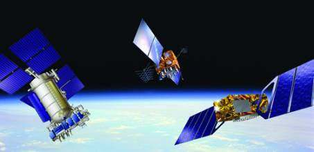
In terms of its fundamental design, the Global Positioning System is nearly 35 years old. More recent spacecraft designs using modern electronics, new rubidium clocks, better satellite management techniques, and navigation message enhancements have improved performance. But the design of the key resource for manufacturers and users, the GPS signals-in-space, is essentially the same as when the first satellite was launched in 1978: a C/A-code on L1 (centered at 1575.42 MHz) and P/Y-code military signals at L1 and L2 (1227.60 MHz).
Over the next five years, however, this situation will change dramatically.
Beginning with SVN53/PRN17, the first modernized Block IIR (IIR-M) satellite built by Lockheed Martin and launched last September 25, GPS has gained a new open civil signal at L2 (centered at 1227.6 MHz). A third civil signal, L5 (centered at 1176.45 MHz) will arrive with the Block IIF satellites now scheduled to begin launching in 2007.
Both IIR-M and IIF satellites will offer new military M-code signals at L1 and L2 with “flex power” capability of transmitting stronger signals as needed. The L5 civil signal will be broadcast both in phase and in quadrature, with the quadrature signal being broadcast without a data message. Air Force Space Command expects to have a full complement of satellites transmitting L2C and M-code signals by 2013; for L5, fully operational capability is expected by 2014.
Generally, the new signals will be characterized by longer code sequences broadcast at a higher data rate and with slightly more power. Beginning with the IIR-M satellites, the Air Force will be able to increase and decrease power levels on P-code and M-code signals to defeat low-level enemy jamming — a capability known as “flex power.”
These new signal features will support improved ranging accuracy, faster acquisition, lower code-noise floor, better isolation between codes, reduced multipath, and better cross-correlation properties. In short, the new signals will be more robust and more available.
Looking farther ahead, another civil signal at L1 is planned to arrive with the GPS III program. Under a GNSS agreement signed with the European Union in June 2004, this will be a binary offset carrier (BOC 1,1) signal similar or identical to that of the Galileo open signal. This is expected to simplify the combined use of GPS and Galileo signals. Nominal first launch date for a GPS III spacecraft is currently 2013.
Modernization will also take place in the ground control segment. Six GPS monitoring stations operated by the National Geospatial-Intelligence Agency (formerly the National Imagery and Mapping Agency) have been folded into the existing five Air Force GPS monitoring stations (which includes the Master Control Station at Schriever AFB, Colorado.) This will eliminate blank spots in coverage and support Air Force plans to monitor the integrity (or health) of civil signals as well as military signals.
New Political Structure
Under a presidential national security policy directive (NSPD) released in December 2004, a National Space-Based Positioning, Navigation, and Timing (PNT) Executive Committee and Coordination Office have taken over from the Interagency GPS Executive Board (IGEB). Mike Shaw, a long-time GPS hand on both sides of the civil/military interface, stepped in toward the end of 2005 as the first director of the PNT coordination office.
Establishment of the PNT committee — now cochaired by deputy secretaries of defense and transportation, Gordon England and Maria Cino, respectively — kicked GPS leadership up a notch from that of the IGEB. Other members include representatives at the equivalent level from the departments of state, commerce, and homeland security, the Joint Chiefs of Staff and the National Aeronautics and Space Administration.
The committee had met once shortly after its formation under President Bush’s NSPD, but a January 26 gathering marks its first with the current leadership. In addition to getting acquainted with one another and the PNT topic in general, the agenda covered such issues as the DSB task force report, modernization and funding of GPS, and the new UN International Committee on GNSS (see article "What in the World is the UN Doing About GNSS?" in this issue).
Without a director and coordination board in place, the executive committee was unable to get on with many of the tasks assigned it by the presidential directive, including writing a five-year plan for U.S. space-based PNT and appointing an advisory board of outside experts. With Shaw on board, the coordination board now has seven staff members detailed from agencies represented on the executive committee.
A charter for the advisory board has been drafted and awaits approval by the committee, as does a draft of an international PNT strategy prepared by the State Department under the direction of Ralph Braibanti, who heads that agency’s space and advanced technology staff.


