This webinar has taken place. A recorded version is available for on-demand viewing free here.
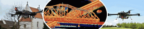
The integration of GNSS and inertial sensors in an aided-inertial navigation system (A-INS) for direct georeferencing (DG) has become a powerful standard for high-accuracy airborne and mobile mapping. Combining DG with light detection and ranging (LiDAR) technology small and light enough to fit onto a UAS is a breakthrough that brings with it many benefits.
This webinar has taken place. A recorded version is available for on-demand viewing free here.
The integration of GNSS and inertial sensors in an aided-inertial navigation system (A-INS) for direct georeferencing (DG) has become a powerful standard for high-accuracy airborne and mobile mapping. Combining DG with light detection and ranging (LiDAR) technology small and light enough to fit onto a UAS is a breakthrough that brings with it many benefits.
Our panel of experts addressed the state of the art and science in direct georeferencing and LiDAR in a web seminar sponsored by Applanix.
Our panel of experts for this exciting event is Lewis Graham, President and Chief Technical Officer of GeoCue Group; James Van Rens, CEO of Riegl USA, and Pierre Chaponniere, an application engineer at YellowScan.
The webinar moderator will be James Poss, Maj Gen (Ret), CEO of ISR Ideas, an intelligence, unmanned aerial systems and cyber warfare consulting firm.
During the live event, audience members will have the opportunity to pose their own questions to the panel of experts.
You may download a PDF of the webinar slides here:
You may view a recorded version of the webinar presentation at the link below. (If you have not registered yet, you will need to do so in order to view the recording.)
View recorded version of the webinar presentation
Panelists
 Lewis Graham is the President and Chief Technical Officer of GeoCue Group, a group of companies who specialize in LiDAR tools and consulting, sensor processing workflow management, point cloud exploitation and small UAS mapping systems. Lewis is a member of the LAS (Point Cloud format) Working Group of ASPRS and a member of the Transportation Research Board (TRB). He is a board member of the M&S division of the National Stone, Sand and Gravel Association (NSSGS) and the International Society for Photogrammetry and Remote Sensing (ISPRS) Foundation. He is the 2017 winner of the ASPRS Fairchild Photogrammetry award. Lewis holds degrees in Physics and Electrical Engineering.
 James Van Rens is the CEO of Riegl USA, the North American distributor of RIEGL Laser Measurement Systems, who is recognized as the performance leader in the mobile mapping, civil infrastructure, airborne scanning, unmanned, hydrographic, bathymetric, mining and terrestrial based industries. Van Rens holds a combination BA/BS degree from Marquette University and has more than 30 years of experience in remote sensing, 3D mapping, and LiDAR technology. He is an industry leader in 3D mapping techniques and their applications and lectures extensively to professional and lay audiences alike.
 Pierre Chaponniere is an application engineer at YellowScan (France). He brings more than 10 years of hands-on field experience dealing with geospatial information in the mineral sector. Having previously worked for consultancy and explorers across Africa, he is familiar with the end-user requirements of remote sensing datasets and more specifically LiDAR products. His skills include GIS systems, ground surveying, 3D modeling, project management and assessment and more recently LiDAR processing. At YellowScan, Pierre looks at support & training, marketing and LiDAR data pre & post processing. He is at the interface between the technical team and the YellowScan user community. Pierre graduated from the Ecole Nationale Supérieure de Géologie de Nancy where he validated his last year at the Witwatersrand University, Johannesburg. He recently completed a remote sensing & GIS Advanced Master from AgroParisTech (Mastère SILAT).
Moderator
 James Poss, Maj Gen (Ret) is the CEO of ISR Ideas, an intelligence, unmanned aerial systems and cyber warfare consulting firm. He is the founder and former Executive Director of the Alliance for System Safety of UAS through Research Excellence (ASSURE), the FAA’s center of excellence for unmanned research. He is a 30-year U.S. Air Force veteran with combat experience in four wars and was the Air Force’s senior career intelligence officer at his transition from active service in March 2013. He is a leading expert on UAS having helped designed the U.S. Air Force’s remote split operations system for UAS control and the Distributed Common Ground Station for UAS intelligence analysis. Gen. Poss also has extensive experience in cyber operations from his assignments with the National Security Agency and as the Air Force lead for stand up of U.S. Cyber Command. He is the 2012 winner of Aviation Weeks’ Curtis Sword Award for his leadership in Anglo-American aerospace relations.
 2010")


