RTK Archives - Page 3 of 4 - Inside GNSS - Global Navigation Satellite Systems Engineering, Policy, and Design

July 30, 2019

Drotek Releases Sirius RTK F9P GNSS Rover

The new Sirius RTK GNSS Rover F9P is meant to be mounted on the vehicle that’s moving. Whereas the base is supposed to be immobile (even though it can be mobile, which implies a loss of accuracy), the rover is the module receiving the corrections, providing the information to the autopilot with its position, heading, height…

Read More >

By Inside GNSS
February 14, 2019

Sokkia Offers New GNSS Integrated Receiver for Diverse Applications

Sokkia has introduced the latest addition to its GNSS integrated receiver line — the GRX3 which is designed to provide a smaller, lighter and fully integrated GNSS solution.

“The multi-constellation GRX3 receiver is built to offer a complete and versatile solution to provide best-in-class positioning performance for a wide variety of precision applications,” said Alok Srivastava, director of product management.

Read More >

By Inside GNSS
February 6, 2019

ACEINNA Launches Centimeter Accurate, Multi-Constellation, Multi-Band, Dual Antenna, RTK, GNSS/INS Solution

ACEINNA has launched its new INS1000 high performance dual-band RTK INS (Real-Time Kinematic Inertial Navigation System) with built-in inertial sensors for construction, agriculture and automotive applications.

The INS1000 embeds ACEINNA’s 9 degree-of-freedom inertial sensor technology to achieve Automotive Dead Reckoning performance in GNSS challenged environments like urban canyons, heavily tree-lined roads, tunnels, underpasses, bridges, etc.

Read More >

By Inside GNSS
January 18, 2019

CHC Navigation Introduces APACHE 3 Portable USV Solution

CHC Navigation has announced the immediate availability of its new APACHE 3, a lightweight portable unmanned surface vessel.

“Featuring triple-hulled and shallow draught design, the APACHE 3 is a portable autonomous USV for bathymetric surveys of lakes, inland rivers and coastal areas.”, said Yann Yan, product manager of USV Solutions. “Its compact size and light weight (1-meter length and 7kg mass without instrument) allows one person to operate the system easily.”

Read More >

By Inside GNSS
October 15, 2018

SBG Systems’ Navsight Land/Air Solution Released at INTERGEO

At this week’s INTERGEO show in Frankfurt, Germany, SBG Systems released the Navsight Land/Air Solution, a full high performance inertial navigation solution designed to make surveyors’ mobile data collection easier, whether it is mobile mapping, GIS, or road inspection.

Navsight Land/Air Solution consists of an Inertial Measurement Unit (IMU) available at two different performance levels, and connected to Navsight, a rugged equipment embedding the fusion intelligence, the GNSS receiver, and all connections to external equipment such as LiDAR, cameras, computer, etc.

Read More >

By Inside GNSS
August 23, 2018

Geneq Releases F90 GNSS/RTK Survey Receiver

Featuring multi constellation with L-Band and satellite-based augmentation system (SBAS), theF90 GNSS/RTK receiver from Geneq Inc., tracks GPS, GLONASS, Galileo and BeiDou and can maximize the tracking to observe all visible GNSS satellite signals, thereby providing maximum performance for accuracy and real-time measurements. F90 also supports L-Band function and can get centimeter accuracy with just one receiver, according to the company.

Read More >

By Inside GNSS
June 14, 2018

Broadgnss Releases High Precision GPS Receiver

Broadgnss Technologies recently announced at the 9th China Satellite Navigation Conference a new high precision satellite position receiver with patented RAC(Real-time Array Calibration) technology. It features positioning accuracy better than one meter (up to 10 centimeters). By receiving only single frequency (GPS L1) satellite signals, the RAC technology in high precision satellite positioning frees the dependence on traditional augmentation network and significantly reduces the cost to enable high precision satellite positioning to enter large-scale applications, according to the company.

Read More >

By Inside GNSS
June 8, 2018

Inertial Labs Introduces Dual Antenna GNSS-Aided INS

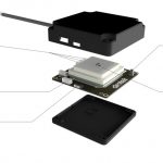
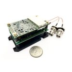
Inertial Labs, Inc., a developer and supplier of inertial sensors & systems, has released an affordable, multi GNSS constellation, 1 cm RTK accuracy dual-antenna GPS-Aided Inertial Navigation System (INS).

The “INS-DL” and the OEM version “INS-DL-OEM” are multi-constellation (GPS, GLONASS, Galileo, BeiDou) GPS-Aided INS designed to achieve 1 cm Position and 0.05° Heading, Pitch & Roll accuracy. These highly precise and high-accuracy INS are available for around $5,000 USD.

Designed for developers of autonomous and unmanned systems; vehicles and small robots for precision agriculture; payloads for remote sensing and survey applications, the GPS-Aided “INS-DL” and “INS-DL-OEM” are compact and deliver high performance.

The “INS-DL” can be supplied as a classic Inertial Navigation System, which outputs Position, Orientation and IMU data for real-time and post-processing operation, or as an advanced, GPS-Aided Motion Reference Unit, which outputs Position, Velocity, Heading, Pitch, Roll, Heave, Surge, Sway and Significant Wave Height data for survey, hydrography, bathymetry and motion control.

“GPS-Aided INS-DL is a result of significant efforts of our R&D team. It is a market-oriented solution, geared towards applications, requiring the best combination of high performance and low cost” said Jamie Marraccini, Inertial Labs’ CEO & President, in a press release.

This year, Inertial Labs celebrates its 17th anniversary of supplying inertial sensor-based solutions for land, marine and aerospace applications. Since 2001, thousands of inertial systems, as well as those fused with other technologies like optical, laser, and GNSS systems, have been successfully delivered to customers for AGV, UAV, AUV, UUV, robots, land vehicles etc.

By Inside GNSS
June 6, 2018

Topcon Positioning Group Releases Data Controller with Advanced Speed and Power Functionality

The Topcon Positioning Group today introduced the new T-18 handheld controller designed to drive geopositioning, construction, mapping and vertical construction applications.

The controller includes a 3.7-inch sunlight-readable display with a 1gigihertz processor, 1GB of internal storage, and up to 10 hours of battery life.

“For MAGNET® Field data collection, the T-18 controller offers a durable ergonomic solution with faster processing, a larger screen, better connectivity and longer battery life than previously available comparable systems,” said Ray Kerwin, director of global surveying products.

The T-18 features a 3.5G cellular modem for connectivity with Topcon MAGNET solutions for sending and receiving data to the cloud company account.

“The cellular option makes it easy to communicate with field crews when projects need to be changed or if important data is required back in the office. Additionally, the modem can be used for RTK (real-time kinematic) correction services,” said Kerwin.

Additional key features include standard Bluetooth and Wi-Fi connectivity, as well as an IP65 rating for dust and water protection in demanding job site conditions.

By Inside GNSS
May 29, 2018

Commercial UAV EXPO Returns to Las Vegas in October


Commercial UAV EXPO Americas 2018 takes place October 1-3 at The Westgate in Las Vegas, Nevada. If you register by May 31, you can save $300 and also enter for a chance to win two free hotel nights.

A successful drone operation depends on reliable and up-to-the minute information. It’s not easy to keep up when the technology and regulations are constantly evolving. Fortunately, this event brings together the key people, the newest technology and the education you need for success — Commercial UAV Expo Americas. 

Here’s a sample of the conference programming:

Plenaries:

  • Regulatory & UTM Updates
  • IPP Update & Progress to Date
  • Powering Drones — Latest Developments
  • Security: Data, Hacking, Counter-Drone & Privacy
  • Drone Programs: In-House or Outsource?
  • Urban Air Mobility: What the Sky will Look Like in the Future

Vertical Industry “Deep-Dive” Tracks:

  • Construction
  • DOTs & Infrastructure
  • Mining & Aggregates
  • Precision Agriculture
  • Process & Power
  • Public Safety
  • Surveying & Mapping
  • Utilities
  • Wind Turbines, Cell Towers, Large-Scale Solar

Below is a selection of confirmed speakers:

  • Greg Agvent, CNN
  • Assel Ayapova, AES
  • Jaz Banga, Airspace Systems, Inc.
  • Sam Billingsley, Ragan-Smith Associates
  • Robert Blair, Three Canyon Farms
  • David Boardman, Stockpile Reports
  • Philip Buchan, Cyberhawk Innovations
  • Andrew Carey, Rio Tinto Kennecott Utah Copper
  • Gary Cathey, California Department of Transportation
  • Darshan Divakaran, North Carolina Department of Transportation
  • Todd Domney, Sumac Geomatics
  • Douglas Spotted Eagle, Sundance Media
  • Lisa Ellman, Hogan Lovells & Commercial Drone Alliance
  • Dan Elwell, FAA
  • Richard Fields, Los Angeles Fire Department
  • Dyan Gibbons, Trumbull Unmanned
  • Shayne Gill, AASHTO
  • Jason Goodick, Entergy Services, Inc
  • Lewis Graham, AirGon LLC
  • Chad Karlewicz, Renton Police Department
  • Young Kim, Digital Harvest
  • Matthew Klein, US Bureau of Reclamation
  • Brad Koeckeritz, US Department of the Interior
  • Richard Lopez, Hensel Phelps
  • Jeff Lorton, Duke Joseph Agency
  • Daniel Marek, Nevada Highway Patrol
  • George Mathew, Kespry
  • Harold Miller, Entergy Services, Inc.
  • Scott Mlakar, Willoughby Fire Department / Lake County UAS
  • Anil Nanduri, Intel
  • Michael Perry, DJI
  • Harrison Andrew Pierce, San Diego Homeland Security
  • Art Pregler, AT&T
  • Michael Ralston, Menlo Park Fire District
  • Michael Singer, DroneView Technologies
  • Colin Snow, Skylogic Research
  • Dave Truch, BP
  • Callum Walter, Queens University
  • Gretchen West, Hogan Lovells & Commercial Drone Alliance
  • Tracy Wilkinson, Renton Police Department
  • Mike Winn, DroneDeploy

Precision measurement professionals rely on Commercial UAV Expo to deliver the high-level content and quality programming they need for complex projects.

Check www.expouav.com for continual updates and here to register.


By Inside GNSS
May 14, 2018

Septentrio Releases AsteRx SB, a Compact and Ruggedized GNSS Receiver

GNSS receiver manufacturer Septentrio announced the arrival of its AsteRx SB,  which was first showcased at Expomin in Santiago, Chile and Intermat in Paris, France, and then was on display at the recentIEEE/ION Position Location and Navigation Symposium (PLANS) in Monterey, California.

The AsteRx SB delivers Septentrio’s ground-breaking quad-constellation RTK in a low-power, IP68 compliant housing. Built around the hugely successful AsteRx-m2 GNSS receiver engine, the AsteRx SB features WiFi, Bluetooth, USB, Ethernet and serial connectivity. Septentrio’s GNSS+ suite of positioning algorithms converts difficult environments into good positioning: LOCK+ technology to maintain tracking during heavy vibration, APME+ to combat multipath and IONO+ technology to ensure position accuracy during periods of elevated ionospheric activity, according to the company.

Read More >

By Stan Goff
IGM_e-news_subscribe