Better positioning for rideshare apps, vehicle navigation in autonomous motorsports and satellite navigation signals for earthquake detection are just a few of the topics student presenters tackled during the first day of the 16th Annual Stanford PNT Symposium.
By Brett Davis and Renee Knight
Attendees gathered at the SLAC National Accelerator Laboratory on Wednesday to listen to the 12 presentations. Other universities represented include Auburn University, the University of Colorado Boulder, Tufts University, Tsinghua University, National Cheng Kung University and the University of Florida.
The symposium is back to an in-person event after two years, though attendees also had the option to watch the presentations virtually.
Several presentations touched on the need to combat signal jamming and spoofing, which poses a risk to airports and other critical areas. Benon Gattis, a student at the University of Colorado Boulder, described a method of building a network of low-cost GNSS monitors that could detect such problems, particularly jamming.
He described building a network of monitors from the Swiss company u-blox. An F9 GNSS receiver equipped with antenna could send data to a central processing computer and can be built for less than $300, Gattis said.
“You can put a whole bunch of them around an airport” or any other location, he said. One model could cover the L1 and L2 band and another could monitor the L5 band.
His research team has set up six such nodes around the world, including the Colorado Springs and Newark, New Jersey airports, along with sites in Boulder, at Stanford in California and in South Korea. They send data once a day to a central processing computer that looks for signs of jamming or spoofing.
Each site must be calibrated individually to reflect the environment, he said. In Newark, for example, truckers using illegal personal jamming devices to block their rigs’ GPS signals caused the local node to report problems too often.
Going forward, he would like to put more processing power in the nodes themselves so they could report data more than once a day, eventually in real time.
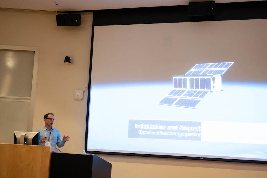
From airports to outer space, Myles Clark of the University of Florida described the efforts of the CubeSat Laser Infrared Crosslink (CLICK) team to build a system to let small CubeSat satellites exchange data and timing information via lasers in space.
CLICK builds on CHOMPTT, which stood for CubeSat Handling of Multi-System Precision Time Transfer (and intentionally called to mind a Florida gator chomp), which aimed to transmit precision time from the ground to space and back. The system has been in orbit since 2018 but never managed to achieve the timing data transfer idea because of problems with a faulty data bus.
CLICK aims to cut out the earthbound link to allow satellites to send data and timing information back and forth in space using a small, low-power optical transponder. The satellites, each about the size of a loaf of bread, could steer their beams toward each other without having to reposition themselves. Each satellite consists of two CubeSats, which are 10 centimeters square. The laser payload takes up about half the space of each.
The CLICK payload is due to be delivered to partner Blue Canyon Technologies in early 2023, although Clark said, “that’s probably a little ambitious.” Launch to the International Space Station is scheduled for no earlier than October 2023. The work is supported by the NASA Small Spacecraft Technology Program.
Tim Dittman of the University of Colorado Boulder, with his presentation “Supervised Machine Learning of High Rate GNSS Velocities for Earthquake Strong Motion Signals,” posed the question: How well can earthquakes be detected in satellite navigation signals?
He described the role of shakemaps, a spatial indication of ground motion after an earthquake, made the case for why GNSS should be used as a seismic sensor and went over some of the challenges, including noise. One of the biggest benefits of using GNSS is it doesn’t saturate at higher magnitudes like other early warning algorithms.
“It complements the dynamic range,” he said. “Inertial sensors can saturate from subsequent waves.”
When comparing his model to existing detection models, he noted the main difference was precision. These measurements can be added to the shakemaps to get more areas where motion occurred.
“This is not earthquake prediction,” he said. “But it can mean minutes or seconds, so you might be able to stop a train or stop a surgery or just duck and cover.”
Other topics covered include using graph convolution neural networks for GNSS positioning corrections in smartphones, developing star tracker algorithms for small satellites and adapting to distribution shifts in satellite pose estimation.
The symposium continues on Thursday with 12 more presentations from invited speakers. Topics include PNT challenges, protecting position solutions, avian navigation and authentication and other new services on Galileo. The symposium ends with a dinner on Thursday evening.


