SBG Systems plans to introduce its newest line of INS/GNSS systems for drone-based surveying integrators at AUVSI’s XPONENTIAL show in Chicago later this month.
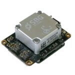
Quanta UAV and Quanta UAV Extra are small, lightweight, low-power inertial navigation systems that offer two different levels of accuracy, according to a news release. They’re developed for compact LiDAR to high-end beyond visual line of sight (BVLOS) mapping solutions. Both offer precise orientation and centimeter level position data that’s available in real time and for post-processing.
Because they’re direct geo-referencing solutions, there’s no need for ground control points or overlapping. They also can be used as high-end navigation solutions to feed the UAV autopilot. Tight integration with in-house IMUs, advanced calibration techniques and algorithms help ensure consistent behavior in all weather conditions, as well as a robust position even if the drone gets too close to buildings, electrical lines, or trees.
The Quanta UAV line comes with Qinertia, SBG’s post-processing software. The software gives users access to offline RTK corrections from more than 7,000 base stations located in 164 countries. Trajectory and orientation are improved by processing inertial data and raw GNSS observables in forward and backward directions. The software also computes base station position.
To view a video, click here.

