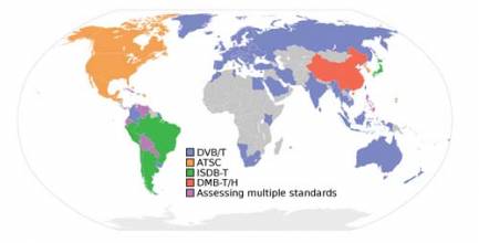
The Digital TV Case
Working Papers explore the technical and scientific themes that underpin GNSS programs and applications. This regular column is coordinated by Prof. Dr.-Ing. Günter Hein, head of Europe’s Galileo Operations and Evolution.
Global Navigation Satellite Systems Engineering, Policy, and Design
Working Papers explore the technical and scientific themes that underpin GNSS programs and applications. This regular column is coordinated by Prof. Dr.-Ing. Günter Hein, head of Europe’s Galileo Operations and Evolution.

 One of 12 magnetograms recorded at Greenwich Observatory during the Great Geomagnetic Storm of 1859
 1996 soccer game in the Midwest, (Rick Dikeman image)
 Nouméa ground station after the flood
 A pencil and a coffee cup show the size of NASA’s teeny tiny PhoneSat
 Bonus Hotspot: Naro Tartaruga AUV
 Pacific lamprey spawning (photo by Jeremy Monroe, Fresh Waters Illustrated)
 “Return of the Bucentaurn to the Molo on Ascension Day”, by (Giovanni Antonio Canal) Canaletto
 The U.S. Naval Observatory Alternate Master Clock at 2nd Space Operations Squadron, Schriever AFB in Colorado. This photo was taken in January, 2006 during the addition of a leap second. The USNO master clocks control GPS timing. They are accurate to within one second every 20 million years (Satellites are so picky! Humans, on the other hand, just want to know if we’re too late for lunch) USAF photo by A1C Jason Ridder.
  Detail of Compass/ BeiDou2 system diagram
 Hotspot 6: Beluga A300 600ST

1. HERE, KITTY KITTY
Santa Cruz, California USA
√ First, get the cougar on the treadmill . . . that’s what UC Santa Cruz researchers did to measure baseline behavior and design a tool that tells what puma concolor do every minute. Their super-advanced CARNIVORE collar uses GNSS and a 3-axis accelerometer to create a 24-hour diary of the wild life.

First, let’s review the record of presidential leadership in GPS.
In 1983, following the shooting down of an errant Korean airliner over Soviet airspace, President Ronald Reagan ordered the U.S. Air Force to make GPS available for civilian use so that such navigational errors could be avoided in the future.
George H. W. Bush was commander in chief in 1991 during the first Persian Gulf when GPS helped coalition troops throw the so-called “left hook” by navigating through the desert around entrenched Iraqi troops in Kuwait.
By Inside GNSS
Budget storms have reappeared on the horizon and the fore¬cast for defense expenditures, including for the GPS program, is grim with a high probability of ugly.
By Dee Ann Divis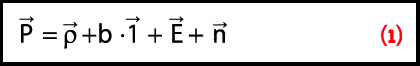 Equation 1
Q: How does measurement differencing affect my computed position?
A: The short answer is, “That depends.”
Standalone, or undifferenced, measurements obviously produce the poorest positioning performance. However, how we proceed from this most basic data processing approach may affect the computed solution. In this article, we look at the details of why this occurs.
By Inside GNSS
Working Papers explore the technical and scientific themes that underpin GNSS programs and applications. This regular column is coordinated by Prof. Dr.-Ing. Günter Hein, head of Europe’s Galileo Operations and Evolution.
By Inside GNSS
CORS and OPUS for Engineers
Edited by Tomás Soler
PUBLISHED BY THE AMERICAN SOCIETY OF CIVIL ENGINEERS
One of 12 magnetograms recorded at Greenwich Observatory during the Great Geomagnetic Storm of 18591996 soccer game in the Midwest, (Rick Dikeman image)Nouméa ground station after the floodA pencil and a coffee cup show the size of NASA’s teeny tiny PhoneSatBonus Hotspot: Naro Tartaruga AUVPacific lamprey spawning (photo by Jeremy Monroe, Fresh Waters Illustrated)“Return of the Bucentaurn to the Molo on Ascension Day”, by (Giovanni Antonio Canal) CanalettoThe U.S. Naval Observatory Alternate Master Clock at 2nd Space Operations Squadron, Schriever AFB in Colorado. This photo was taken in January, 2006 during the addition of a leap second. The USNO master clocks control GPS timing. They are accurate to within one second every 20 million years (Satellites are so picky! Humans, on the other hand, just want to know if we’re too late for lunch) USAF photo by A1C Jason Ridder. Detail of Compass/ BeiDou2 system diagramHotspot 6: Beluga A300 600ST1. AQUARIUS
Buenos Aires, Argentina and Vandenberg AFB, California, USA
What have we learned from the LightSquared fiasco?
Aside from the fact that someone gambling with other people’s money, with friends in high places benefiting from his largesse, can make the law stand on its head and our hair stand on end.
But then, we already knew that.
Just because the forces behind the broadband cellular company, Philip Falcone and Harbinger Investments, made their money by betting against the housing bubble doesn’t take away from the fact that they represent the same crew who helped take down the world economy in 2007.
By Inside GNSS
The gloves have come off now that test results show clearly the probable effects on GPS of LightSquared’s proposed wireless broadband network: widespread, debilitating interference to GPS receivers.
By Dee Ann Divis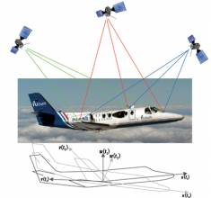
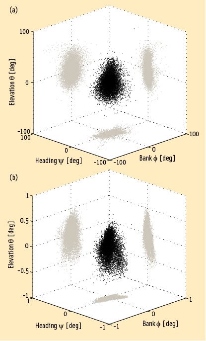 FIGURE 1: Heading, bank and elevation angles of an actual platform carrying two perpendicular two meter-long baselines. The attitude solutions are shown for both the derived, or float, measurements (top), as well as the carrier phase-based, or fixed, measurements obtained after having correctly resolved the integer ambiguities (bottom). Precision differs between the methods by two orders of magnitude. Gray dots represent the two-dimensional projections on each of the three coordinate planes.
Working Papers explore the technical and scientific themes that underpin GNSS programs and applications. This regular column is coordinated by Prof. Dr.-Ing. Günter Hein, head of Europe’s Galileo Operations and Evolution.
By Inside GNSS
Q: What is a virtual reference station and how does it work?
A: To reach centimeter-level — or even better — accuracy of positioning typically requires use of precise dual-frequency carrier phase observations. Furthermore, these observations are usually processed using a differential GNSS (DGNSS) algorithm, such as real time kinematic (RTK) or post-processing (PP). Regardless of the specific differential algorithm, however, implicit in the process is an assumption that the quality of the reference station data is consistent with the desired level of positioning accuracy.
By Inside GNSS
Washington View appears in each issue of Inside GNSS. It covers U.S. policy and program issues involving the Global Positioning System and other GNSSes. Reporting from Washington, D.C., columnist Dee Ann Divis has written about GNSS and the aerospace industry since the early 1990s in GPS World, Geo Info Systems, Jane’s International Defense Review, the Los Angeles Times, AeroSpace Daily and other publications.
By Dee Ann Divis