
From an Australian garage to global validation, Locata’s TimeLoc technology is redefining terrestrial precision positioning and timing.
By Richard Thomas, Abe Peck, Vicki Speed
For more than four decades, satellite-based global navigation systems have served as the invisible infrastructure of the modern world. GPS and its international counterparts underpin navigation, telecommunications, finance and defense—technologies that together define 21st century life. Yet, as the dependence deepens, so do the vulnerabilities. Jamming and spoofing have become easy and commonplace, from conflict zones to commercial ports. In the world’s most sophisticated mines, in dense urban corridors, and under roofs where signals fade, GPS alone cannot sustain the accuracy modern applications demand.
This gap—the inability of space-based signals to penetrate, persist or resist interference—has created an urgent demand for Complementary Positioning, Navigation and Timing (C-PNT). In that space, a small Australian company has quietly built a terrestrial counterpart that operates without satellites, atomic clocks or external corrections. That company is Locata.
Reinventing Synchronization
Locata’s founders, David Small and Nunzio Gambale, began not as engineers but as musicians. In the mid-1990s, they were experimenting with a GPS-based tourism app that would trigger audio and video as a tour bus passed local landmarks. It worked—until they went inside a museum and the satellite signals…vanished. The experience revealed a simple truth: GPS, for all its global reach, had local blind spots.
“What we saw was a system full of holes,” Gambale later recalled. “Malls, mines, ports, warehouses, urban canyons—all the places where productivity was moving—were exactly the places GPS couldn’t reach.”
The pair decided closing those holes meant building a ground-based positioning system that could emulate GPS performance anywhere, even indoors. That ambition presented them with a fundamental obstacle: synchronizing multiple transmitters to billionths of a second without having access to the atomic clocks that fundamentally underpin satellite positioning systems.
Solving that problem has defined the innovation Locata created for the science of PNT.

TimeLoc: The Clockless Breakthrough
TimeLoc has become the core of Locata’s terrestrial architecture. Instead of relying on satellite-borne atomic clocks, TimeLoc synchronizes a network of small ground transmitters—called LocataLites—through a self-referencing feedback loop. Each unit continuously measures and corrects its timing relative to neighboring transmitters. Through this closed-loop process, the entire network converges on a common timescale, achieving sub-nanosecond synchronization without any external clock reference.
The result is a terrestrial grid capable of transmitting GPS-like ranging signals with atomic-clock-level precision. Locata receivers, or “Rovers,” compute position and time using those signals just as a GNSS receiver would, but without dependence on satellites.
Independent testing confirmed that a properly configured LocataNet can maintain timing stability better than one billionth of a second for months or even years. “As long as we have power to the LocataLites, they autonomously remain synchronized…essentially forever,” Small has said.
From this breakthrough grew a vision: a terrestrial complement to GNSS that could provide local, sovereign control of high-precision PNT—indoors, in jammed environments and across critical infrastructure.
Proof Point One: White Sands Missile Range
Locata’s first large-scale validation came not from industry but from defense. In 2011, the U.S. Air Force (USAF) selected the company to provide an alternative truth reference system for aircraft testing at White Sands Missile Range (WSMS) in New Mexico. The question was whether a LocataNet could scale across thousands of square kilometers and deliver centimeter-level accuracy at aircraft speeds while GPS was deliberately jammed.
It could—and still does today. The White Sands installation covers about 2,500 square miles of airspace, its LocataLites synchronized entirely by TimeLoc. Independent USAF reports have verified centimeter-level aircraft positioning and nanosecond timing, even under full-spectrum GNSS denial. Aircraft acquire signals more than 65 kilometers from the nearest transmitter.
For the Air Force, the demonstration established a terrestrial truth reference system unmatched by any other technology. For Locata, it proved the concept’s scalability and reliability in one of the most demanding test environments on Earth.
Proof Point Two: Boddington Gold Mine
A year later, one of the world’s largest open-pit gold mines presented a different challenge. The Boddington Gold Mine, operated by Newmont in Western Australia and supported by Leica Geosystems (later acquired by Hexagon), required continuous centimeter-level positioning for fleet automation deep within the pit. Satellite signals frequently vanished along the pit walls and at the mine base, forcing costly machine downtime.
Leica engineers worked with Locata to integrate a LocataNet with their Jigsaw Positioning System, effectively merging GPS and Locata into a hybrid PNT environment. When satellite visibility dropped, Locata seamlessly maintained centimeter-level position data for the mine’s haul trucks and shovels. The mine reported that the system paid for itself within 90 days through reduced interruptions—a milestone that demonstrates Locata’s compatibility with existing GNSS workflows, rather than competition with them.
Proof Point Three: NASA Langley
In 2015, NASA’s Langley Research Center adopted Locata as a core positioning technology for safety-critical unmanned aircraft systems testing in conjunction with the FAA. Langley’s goal was to validate non-GPS navigation for UAVs operating over urban areas, and near buildings and structures.
NASA engineers confirmed Locata’s phase and pseudo-range methods paralleled GNSS mathematics closely enough for existing navigation algorithms to ingest the data with minimal modification. The tests validated centimeter-level positioning and sub-nanosecond timing across mixed indoor/outdoor environments—precisely the conditions that defeat satellite-based navigation.

Proof Point Four: The European Commission’s JRC Evaluation
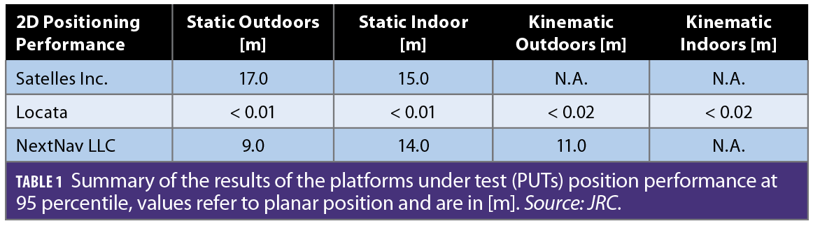
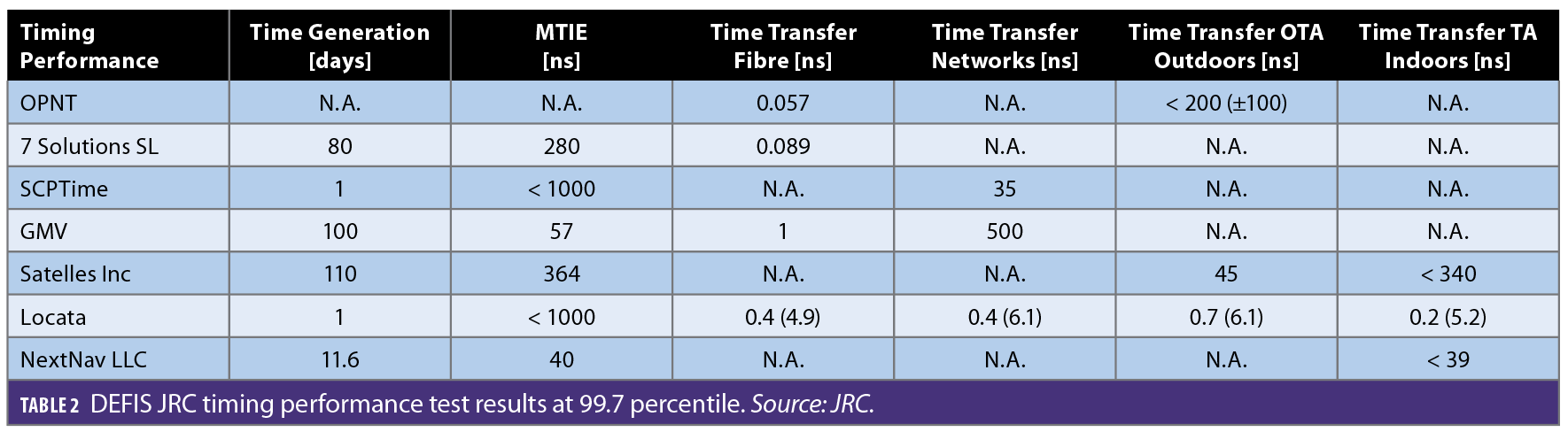
Locata’s most rigorous independent trials came from Europe. In 2023, the European Commission’s Joint Research Centre (JRC) completed an eight-month evaluation of alternative PNT systems for potential deployment within the EU. Thirty-two companies applied; seven were selected for final testing. Locata was awarded two of the seven contracts—one for positioning and one for timing.
For the timing test, the company deployed a TimeLoc chain spanning 105 kilometers, cascaded through eight LocataLites. The JRC’s independently measured time deviation across that span was less than 400 picoseconds—a fractional error so small it’s difficult for non-engineers to fathom—one picosecond is to a second as one second is to 31,700 years.
The JRC’s published report concluded that Locata was the only system tested to deliver consistent, centimeter-level positioning and picosecond-level timing in every environment, including indoor, outdoor and transition zones. The findings validated Locata’s claim of clock-free synchronization and established it as a fully mature terrestrial complement to GNSS.

The Physics of Precision
At the core of TimeLoc’s precision is a method for removing the drift that accumulates when independent oscillators age or fluctuate with temperature. Locata’s algorithmic “Time Lock Loop” continually compares the phase of signals between transmitters, and through what engineers call common-mode differencing aligns each unit’s oscillator accordingly. Because every node actively participates in TimeLoc, the distributed network as a whole behaves as one, sub-billionth-of-a second, synchronized timebase. To a novice, TimeLoc can literally make it look like “time is standing still.”
Locata’s nodes “mesh,” yielding a unified timebase without any atomic reference. The principle may seem simple, but implementing it requires millions of lines of code and years of iteration in the field.
This time synchronization capability gives Locata a strategic advantage: Networks can be scaled, relocated or duplicated without recalibration. In effect, TimeLoc today enables better than GPS-grade synchronization without GPS or atomic clocks—a property increasingly valuable for national infrastructures seeking autonomy in timing.

Solving Multipath: Correlator Beam Forming
Accurate positioning in enclosed or cluttered environments requires more than synchronization. Multipath—signals bouncing from walls or machinery—can overwhelm receivers with incorrect timing and positioning measurements.
To address this, Small invented Correlator Beam Forming, a signal-processing method that creates a time-multiplexed phased array using a single radio front-end. Traditional phased-array antennas require complex, expensive hardware with myriad radio front-end receivers. Locata’s approach performs the equivalent operation in software, forming millions of tight beams that track direct signal paths and suppress reflections.
The first embodiment was the VRay Orb, a basketball-sized, 60-element antenna producing 2.5 million beams per second. The beamforming adapts dynamically as a platform moves, maintaining direct-path lock even in dense multipath environments such as indoor warehouses or cluttered steel environments like container ports.
The company is now testing its new miniature Orb 120 —about the size of a coffee cup—aimed at drones, forklifts and other compact platforms. Prototype designs have already demonstrated feasibility for integration into consumer-scale hardware, from forklifts to industrial robots to smartphones.
Built for Resilience
From the outset, Locata’s engineers designed their system to survive in the noisy 2.4 GHz band—the same unlicensed spectrum used by Wi-Fi. That choice, forced by regulatory constraints, had an unintended benefit: It hardened the technology against interference.
“GPS signals are extraordinarily weak,” Small noted in an early briefing. “A simple jammer can disrupt them. Locata signals are billions of times stronger at the receiver.”
Because Locata networks operate under local control, transmit power can be adjusted to suit the environment. Jamming attempts are easily detected and located. In effect, the network’s own geometry and signal strength becomes a defense mechanism, giving it inherent resilience in contested or congested spectrum.
Lessons From the Red Zones
When Gambale addressed the PNT Leadership Summit in September, his slides carried a blunt message: “Don’t deploy your grandfather’s GPS backup.” The presentation, titled “Report from the Red Zones,” illustrated how civilian systems dependent on GNSS are failing badly in areas of electronic warfare—from Poland’s Baltic ports to Ukrainian agriculture to Middle Eastern construction companies.
In these “red jamming zones,” precision agriculture systems report coordinate shifts of hundreds of meters. Polish offshore wind-farm construction halts under sustained GPS jamming from nearby Kaliningrad. Even commercial container ports see autonomous gantry cranes stop mid-operation when satellite signals disappear.
One large Baltic port Locata is working with, Gambale said, “has €500 million worth of GNSS-dependent autonomous machines, which are fundamentally ‘turned into bricks’ when GNSS jamming is taking place. This is a serious, existential threat for Poland’s Critical National Infrastructure. We don’t know of any other technology that can deliver the centimeter-level radiopositioning the machines need 24/7/365, across the entire port area, so they can function without GNSS.”
The takeaway is clear: Next-generation C-PNT must meet aviation-grade thresholds of Accuracy, Integrity and Resilience (A-I-R), Gambale said. Laboratory simulations and marketing blurb are not enough; systems must prove performance in real-world environments.
Locata’s long record of field validation—from mines to missile ranges—has now positioned it as one of the few technologies meeting those proven standards today.
Complement, Not Competitor
Locata’s founders have never claimed to replace GPS. The system’s strength lies in complimentary integration—extending GNSS into environments and applications where satellites cannot operate. In a hybrid configuration, GPS can provide a global reference while Locata delivers local precision and continuity.
In the Boddington Gold Mine example, the two systems work in concert: GNSS established absolute coordinates outside the mine pit; Locata maintained accuracy when sky visibility is inadequate in many places. The same model applies to ports, airports, indoors and urban infrastructure.
In practice, GPS + Locata creates a resilient architecture where one layer fortifies the other. It embodies the multi-layered strategy that experts like Dr. Brad Parkinson, the “father of GPS,” have long advocated under the Protect–Toughen–Augment (PTA) framework.
Sovereignty and Spectrum
As nations recognize the strategic vulnerability of space-based PNT, terrestrial solutions are becoming instruments of sovereignty. The U.S. Department of Transportation and its Volpe Center have launched recent programs to evaluate mature, deployable C-PNT technologies—systems with a Technology Readiness Level (TRL) of 8 or higher that can operate within six months of award.
Locata already meets that standard. Its installations in defense, mining, ports and indoor contexts demonstrate operational and commercial success, and its new software-defined radio architecture promises rapid future deployment across licensed or shared spectrum bands.
Gambale has argued publicly that allocating a protected frequency for terrestrial PNT—analogous to GPS’s own protected bands—would multiply system range and penetration. “Give us 30 watts instead of a tenth,” he has said, “and our signal will go through buildings like butter.”
The argument is less about competition for bandwidth than about recognizing that ground-based precision timing deserves the same national protection as space-based navigation.
Building Ubiquitous Terrestrial PNT
Over the past two decades, the two founders surrounded themselves with an extremely tight and dedicated team of engineers that have helped solidify Small’s inventions into rock solid TRL9 commercial systems. The team’s mission has remained crystal clear throughout: non-GNSS-based PNT that Locata users can bet their lives upon.
To date, this collective mission has gained Locata more than 170 patents and licensing arrangements with major industrial and defense partners, most still under nondisclosure agreements(NDAs). The company’s immediate focus is cost reduction and miniaturization—moving from bespoke hardware toward chipset integration, the same trajectory GPS followed in its early decades.
The vision is straightforward: compact LocataLites mounted in ceilings, poles or towers could provide centimeter-accurate, authenticated positioning across entire industrial zones, critical infrastructure or even cities. Warehouses, ports, logistics centers, airports, data centers and more could maintain assured time and position, even if satellites go dark.
For national infrastructures, this model provides a blueprint for sovereign resilience—a self-contained layer that can be deployed to continue operating through jamming, spoofing or orbital disruption.
The Long Road to Credibility
Locata’s journey has not been easy. For years, the idea of clockless synchronization was dismissed as impossible. When Gambale first presented Locata’s initial results at an Institute of Navigation (ION) conference, one extremely well-known GPS expert literally pounded the table demanding, “Where are your clocks?” The textbooks he’d studied taught him it couldn’t be done.
Since that outburst, Locata has unequivocally proven the textbooks he read now have to be re-written. Renowned, independent agencies on three continents have definitively proven that Locata is both real and transformational. Locata’s TimeLoc synchronization has been verified by NASA, Leica, Maersk, the U.S. Air Force, the EC’s JRC, and many more under NDA. Each validation reinforced the same finding: The system delivers high-precision GPS-class accuracy and timing without requiring atomic clocks or satellites.
The Next Beat
As global policy shifts from awareness to implementation of resilient PNT, Locata’s technology occupies a pivotal niche. It is not a rival to GPS but an enabler of the Protect–Toughen–Augment model—ground truth to complement and buttress space truth.
In a world where positioning and time have become as fundamental as power or communications, Locata demonstrates that those services need not depend solely on orbiting assets. They also can be anchored to Earth itself, and owned by nations and entities that do not (and can never) possess constellations.
From two musicians working to produce a tour-bus app in the early days of GPS to a revolutionary innovation validated by the world’s foremost navigation authorities, Locata’s evolution underscores a broader principle: The next era of assured positioning will belong not to satellites alone, but to the synergy between sky and ground.


