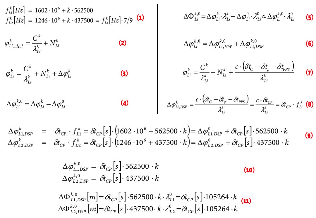
 EQUATIONS 1 -11
GLONASS currently uses a frequency division multiple access (FDMA) technique to distinguish the signals coming from different satellites in the Russian GNSS constellation. The GLONASS L1 and L2 bands are divided into 14 sub-bands, and each satellite transmits in one of these.
The sub-bands are identified by frequency numbers k, from -7 to 6. The GLONASS L1 and L2 carrier frequencies, in hertz, at a frequency number k are defined by:
 FIGURE 2: Example of a national geoid (upper diagram) and a correction surface for the transformation from the new orthometric height system to the old height system (lower diagram). Country is Switzerland. Geoid undulations range from 45 to 55 meters in ETRS89 and from -5 to +5 meters in the national System CH1903+. Lower diagram: Correction surface to transform from the new orthometric height system (LHN95) to the old height system LN02 with corrections from -0.10 to 0.55 meters.
Q: How do GNSS-derived heights differ from other height systems?
A: Height estimation using GNSS always seems to be trickier than horizontal coordinate estimation.
Why?
On the one hand, the GNSS technique has error sources that are more critical in the vertical direction. Height estimates are weaker because of a combination of satellite geometry, the presence of strong correlations to other parameters, such as atmospheric delays, and the antenna phase center model applied during data analysis.
By Inside GNSSWorking Papers explore the technical and scientific themes that underpin GNSS programs and applications. This regular column is coordinated by Prof. Dr.-Ing. Günter Hein, head of Europe’s Galileo Operations and Evolution.
By Inside GNSSAn increasingly urgent call to certify performance of Global Positioning System (GPS) receivers is being heard from several sectors of the national political and business landscape. This issue has arisen now as a direct result of the LightSquared initiative that has generated so much attention over the last 18 months.
Instead of diving into those issues directly, however, a little historical perspective is in order first — and it’s amazing in itself that a technology as new as GPS in the public eye would actually have a history to reflect upon, but it does.
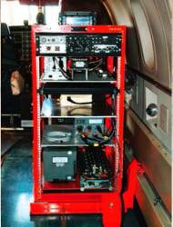
By Inside GNSS Typical Rack-Mounted UHARS System
A next-generation “truth” reference system for the U.S. Air Force (USAF) — the Ultra High Accuracy Reference System (UHARS) — is currently under development by the 746th Test Squadron (746 TS) at Holloman Air Force Base, New Mexico.
By Inside GNSS Patrick Fenton, Vice President and Chief Technology Officer, NovAtel, Inc.
In the RF (radio frequency) spectrum between 3 kHz and 300 GHz, national and international regulatory agencies have sliced and diced the available frequencies into a crazy quilt of allocations for particular uses. GNSS systems, for example, provide positioning, navigation, and timing services in scattered portions of the L-band between 1170 and 1610 MHz.
By Inside GNSS Mike Perlmutter, Principal, Skylight Navigation
A growing awareness of the limitations and vulnerabilities of GNSS — along with advances in inertial designs and manufacturing — has opened a new era in which these admirably complementary technologies are converging ever more often into integrated products.
By Inside GNSS Dr. Anthony Pratt, Orbstar International Ltd.
In the beginning, there was just the Global Positioning System. But it provided an astounding start to the world of GNSS.
Since the United States declared full operational capability (FOC) for GPS in 1995, two major things have occurred:
By Inside GNSS Christopher Hegarty
Perhaps for the first time in the nearly 40 years of satellite navigation, all four GNSS programs and regional systems appear to have firm — if not always unencumbered — development paths ahead of them.
GPS, GLONASS, Galileo, Compass/Bei- Dou, Japan’s MSAS and QZSS, and India’s GAGAN and IRNSS systems are bringing new or modernizing elements into the world. Key program enablers — such things as budgets, satellite construction, launches and launch vehicles, new signal designs — all appear favorably aligned.
By Inside GNSS One of 12 magnetograms recorded at Greenwich Observatory during the Great Geomagnetic Storm of 1859
 1996 soccer game in the Midwest, (Rick Dikeman image)
 Nouméa ground station after the flood
 A pencil and a coffee cup show the size of NASA’s teeny tiny PhoneSat
 Bonus Hotspot: Naro Tartaruga AUV
 Pacific lamprey spawning (photo by Jeremy Monroe, Fresh Waters Illustrated)
 “Return of the Bucentaurn to the Molo on Ascension Day”, by (Giovanni Antonio Canal) Canaletto
 The U.S. Naval Observatory Alternate Master Clock at 2nd Space Operations Squadron, Schriever AFB in Colorado. This photo was taken in January, 2006 during the addition of a leap second. The USNO master clocks control GPS timing. They are accurate to within one second every 20 million years (Satellites are so picky! Humans, on the other hand, just want to know if we’re too late for lunch) USAF photo by A1C Jason Ridder.
  Detail of Compass/ BeiDou2 system diagram
 Hotspot 6: Beluga A300 600ST

1. DEAD IN THE WATER
San Francisco, California and Washington D.C., USA