Optional Categories Archives - Page 9 of 28 - Inside GNSS - Global Navigation Satellite Systems Engineering, Policy, and Design

Optional Categories

March 12, 2011

Registration opens for 2011 GPS Partnership Council Meeting at Los Angeles AFB

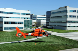
A Coast Guard search and rescue helicopter demonstrates the use of GPS technology at a previous GPS Partnership Council meeting. (Photo: Joe Juarez)

Registration is now open for the 2011 GPS Partnership Council meeting on Tuesday, May 3 and Wednesday, May 4 at the Space and Missile Systems Center (SMC) at Los Angeles Air Force Base in El Segundo, California. 

These military and industry networking meetings, now in their 11th year, are sponsored by the Los Angeles chapter of AFCEA (Armed Forces Communications Electronics Association) and the USAF GPS Directorate, formerly the GPS Wing. 

Read More >

By Inside GNSS
February 17, 2011

FCC Campaign Goes After GPS and Cell Phone Jammers

Website at http://www.jammer-store.com/gps-blockers-jammers.html

The  Enforcement Bureau of the U.S. Federal Communications Commission has announced new efforts to clamp down on the marketing, sale, and use of illegal cell phone and GPS jamming devices.

On February 9, the Bureau released two enforcement advisories and a downloadable poster on cell phone and GPS jamming that warn consumers, manufacturers, and retailers (including online and Web-only companies) that the marketing, sale, or use of such jamming devices is illegal.

Read More >

By Inside GNSS
[uam_ad id="183541"]
January 25, 2011

Lockheed Martin to Test GPS III in Virtual World

Collaborative Human Immersive Laboratory (CHIL) illustration (Lockheed Martin)

GPS III contractor Lockheed Martin has integrated several virtual reality technologies in a new Collaborative Human Immersive Laboratory (CHIL) in Littleton, Colorado, which will be used to validate and test next-generation GPS and other space programs.

With CHIL, Engineers and technicians can explore satellite designs and functions, troubleshoot and fine-tune them in a virtual world before building them in physical space.

Read More >

By Inside GNSS

Three GPS Satellites Moved Into New Positions for More Robust, Accurate Signals

(Update June 15, 2011 Inside GNSS) Completion of Satellite Repositioing Optimizes GPS Constellation

By next June, the United States GPS constellation will attain the most optimal geometry in its nearly 33-year history. Over time, that means a more robust signal, more accuracy and more reliability in GPS-challenged environments.

The 50th Space Wing is in the middle of maneuvering six GPS satellites into more favorable positions. The two-phase operation, called "Expandable-24"  is halfway to completion.

Read More >

By Inside GNSS
January 9, 2011

A Model-Based Approach

For the complete story, including figures, graphs, and images, please download the PDF of the article, above.

Galileo receiver designers require formal interface specifications for the Galileo signal-in-space (SIS) in order to write unambiguous and accurate specifications for Galileo receivers. To compute their positions, Galileo receivers must be able to retrieve timing and orbital information from the data stream conveyed in Galileo analog signals.

Read More >

By Inside GNSS

Indian Regional Navigation Satellite System

FIGURES 1, 2 & 3

For the complete story, including figures, graphs, and images, please download the PDF of the article, above.

In satellite navigation, a GNSS receiver must account for several sources of error such as relativistic effects, atmospheric propagation delay, offset of satellite clocks from system time and satellite ephemeris. In order to accurately compute user position, velocity, and time (PVT), these errors need to be predicted/estimated precisely.

Read More >

By Inside GNSS
[uam_ad id="183541"]
September 7, 2010

When GNSS Goes Blind

A completely GPS-based navigation solution is generally not feasible in GNSS signal–challenged environments such as urban canyons. However, even in these difficult environments a partial set of GPS signal measurements may still be available. For instance, one or two satellites are generally still visible even in dense urban canyons.

Read More >

By Inside GNSS
August 24, 2010

CDR Passed: GPS III Ready for Build Phase

Artist’s rendering of GPS III satellite. Lockheed Martin image

More than two years into a multi-billion-dollar contract, the Lockheed Martin team developing the U.S. Air Force’s next-generation GPS Block III satellites continues to defy the physics of large aerospace programs by successfully completing the program’s Critical Design Review (CDR) phase last week — two months ahead of the baseline schedule.

Read More >

By Inside GNSS
August 17, 2010

A Search for Spectrum

In recent years, researchers have explored possible new allocations for Radio Determination Satellite Service (RDSS) and Radio Navigation Satellite Service (RNSS) spectrum from a regulatory point of view. These studies have mainly discussed S-band and C-band in addition to L-band.

The International Telecommunications Union (ITU) Radio Regulations define RNSS as a subset of RDSS. Although the allocations are differentiated — RDSS usually has a paired uplink — both can actually be used for satellite navigation.

Read More >

By Inside GNSS

GPS IIF-1 Satellite

FIGURE 1: Geographical overview of the 170 IGS stations tracking SVN62/PRN25 during its current 90-day checkout period. The blue curve illustrates the ground track of the spacecraft on August 9, 2010.

For the complete story, including figures, graphs, and images, please download the PDF of the article, above.

On May 27, 2010, the U.S. Air Force successfully launched the first satellite of the Block II “follow-on” (Block IIF) series, the fourth generation of GPS spacecraft that features more precise and powerful signals, an extended design life, and several other technical advances.

Read More >

By Inside GNSS
1 7 8 9 10 11 28
IGM_e-news_subscribe