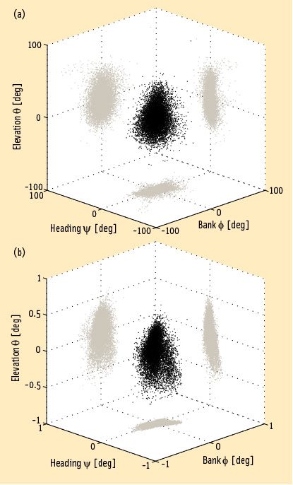
signal Archives - Page 11 of 22 - Inside GNSS - Global Navigation Satellite Systems Engineering, Policy, and Design

signal

September 6, 2011

IET London: Modernised Satellite Navigation Seminar

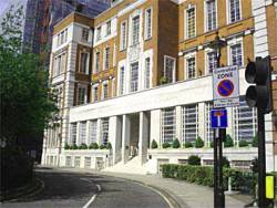
IET headquarters, Savoy Place

The head of the Galileo program division of the UK’s space agency, the PRS expert at the European GNSS agency and the director of the Nottingham Geospatial Institute are just a few of the speakers at a one-day seminar in central London on October 5 called "Modernized Satellite Navigation: The Implementation of GNSS Programmes and Future Challenges."

The Wednesday event will take place at the IET Savoy Place conference center from 9 a.m. until 5 p.m

Read More >

By Inside GNSS
August 26, 2011

Trimble Launches New OEM GNSS Modules, Enclosure

Trimble BD920

Trimble has introduced two new GNSS OEM modules, the BD910 and BD920, featuring centimeter-level, real-time kinematic (RTK) positioning capabilities optimized for high-precision and control applications.

The BD910 and BD920 modules are designed to allow OEMs and system integrators to easily add centimeter-level positioning to specialized or custom hardware solutions.

Read More >

By Inside GNSS
[uam_ad id="183541"]
July 20, 2011

EC Official Adds Galileo, EGNOS Worries to FCC’s LightSquared-GPS Deliberations

European Geostationary Navigation Overlay Service (EGNOS). ESA illustration

Citing European Space Agency (ESA) studies that showed “harmful interference” to Galileo receivers operating up to 1,000 kilometers from LightSquared base stations, a European Commission (EC) official has told the Federal Communications Commission (FCC) about his “deep concerns” about the wireless broadband company’s terrestrial transmissions in the 1525–1559 MHz band next to L1 GNSS frequencies.

Read More >

By Inside GNSS
July 11, 2011

GNSS-Based Attitude Determination

FIGURE 1: Heading, bank and elevation angles of an actual platform carrying two perpendicular two meter-long baselines. The attitude solutions are shown for both the derived, or float, measurements (top), as well as the carrier phase-based, or fixed, measurements obtained after having correctly resolved the integer ambiguities (bottom). Precision differs between the methods by two orders of magnitude. Gray dots represent the two-dimensional projections on each of the three coordinate planes.

Working Papers explore the technical and scientific themes that underpin GNSS programs and applications. This regular column is coordinated by Prof. Dr.-Ing. Günter Hein, head of Europe’s Galileo Operations and Evolution.

Read More >

By Inside GNSS
[uam_ad id="183541"]

China Satellite Conference 2011

Hotel Nikko New Century in Haidian, Beijing

This officially sanctioned conference and equipment exhibtion addresses applications, technologies and trends for China’s satellite communications, broadcasting, remote sensing, navigation and positioning.It will be held at Hotel Nikko New Century in Beijing on October 26.28, 2011.

Subjects of most interest to Inside GNSS readers include:

Read More >

By Inside GNSS
July 8, 2011

NTIA Asks FCC to Delay LightSquared Rollout

Lawrence E. Strickling, National Telecommunications and Information Administration (NTIA)

[Updated July 9, 2011] The National Telecommunications and Information Administration (NTIA) on July 6 asked the Federal Communications Commission (FCC) to hold off on allowing LightSquared to begin commercial operations, pending further evaluation of the cellular broadband system’s interference to GPS.

Read More >

By Inside GNSS
July 5, 2011

Lockheed Martin Team Completes GPS IIIB System Design Review

GPS III satellite. Lockheed Martin illustration

Lockheed Martin has announced the successful, on-schedule completion of a system design review (SDR) for the second-phase of next-generation GPS satellite development, the IIIB increment.

The company’s Space Systems division in Newtown, Pennsylvania, is under contract to produce the first two of a planned eight GPS IIIA satellites, with first launch projected for 2014. The contract includes a Capability Insertion Program (CIP) designed to mature technologies and perform rigorous systems engineering for future GPS III increments.

Read More >

By Inside GNSS
July 2, 2011

FCC Invites Comment on LightSquared Interference to GPS

Individuals and organizations wishing to comment on the recently released technical working group (TWG) report on LightSquared’s interference to GPS as well as the company’s proposal for dealing with the problem have until July 30 to submit statements to the Federal Communications Commission (FCC).

In a release dated June 30, the agency noted that the TWG effort “identified significant technical issues” related to potential LightSquared interference in the upper portion of the L-Band, next to the band used by GPS.

Read More >

By Inside GNSS

GLONASS-K for Airborne Applications

FIGURE 1: GPS/GLONASS L1 frequency band

As is well known, Galileo will become the European complement to the U.S. Global Positioning system.

But what about Russia’s GLONASS?

Although this constellation has been in operation for nearly three decades, the limited number of available satellites along with an uncertain governmental commitment to GLONASS performance until recent years had seriously restricted its use for aviation.

Read More >

By Inside GNSS
July 1, 2011

GPS Interference Testing

Anechoic chamber test site at U.S. Naval Air Systems Command (NAVAIR) facility in Patuxent River, Maryland

Interference can pose a threat to the reception of GNSS signals in a variety of ways. Even low-level signals have the potential to interfere with GNSS receivers, which require very high sensitivity for acceptable performance due to the extremely low received GPS signal power at the Earth’s surface.

Read More >

By Inside GNSS
1 9 10 11 12 13 22
IGM_e-news_subscribe