NovAtel Announces SMART-MR15 GNSS Receiver/Antenna/Cellular Modem
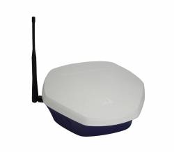
NovAtel SMART-MR15NovAtel Inc. has released its new SMART-MR15 product, a dual-frequency receiver/antenna combination with an integrated cellular modem.
By Inside GNSSGlobal Navigation Satellite Systems Engineering, Policy, and Design
NovAtel SMART-MR15NovAtel Inc. has released its new SMART-MR15 product, a dual-frequency receiver/antenna combination with an integrated cellular modem.
By Inside GNSS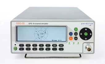 Pendulum GSG-55 Simulator
Spectracom has announced its new 16-channel GPS constellation simulator, the Pendulum GSG-55.
The latest in the Pendulum line of GPS receiver test instruments, the GSG-55 is able to simulate Satellite-Based Augmentation Systems (SBAS), such as the U.S. Wide Area Augmentation System and the European Geostationary Navigation Overlay Service (EGNOS).
By Inside GNSS
Spirent Communications’ Positioning Technology Division, Paignton, UK, has announced that the Japanese Aerospace Exploration Agency (JAXA) has selected Spirent’s GSS8000 Multi-GNSS Constellation Simulator to support further development of the Quazi-Zenith Satellite System (QZSS) program.
Responsible for the development of the initial QZSS user equipment, JAXA is using the GSS8000 to verify QZSS receiver performance.
By Inside GNSS
In his State of the Union address on January 25, President Obama held up the Global Positioning System as a prime example of government providing “cutting-edge scientists and inventors with the support that they need” to create world-leading, job-creating innovation.
The following day, the Federal Communications Commission (FCC) International Bureau approved a conditional waiver allowing LightSquared Subsidiary LLC to build tens of thousands of terrestrial transmitters for wireless communications in frequencies on either side of the GPS L1 band.
By Inside GNSS Collaborative Human Immersive Laboratory (CHIL) illustration (Lockheed Martin)
GPS III contractor Lockheed Martin has integrated several virtual reality technologies in a new Collaborative Human Immersive Laboratory (CHIL) in Littleton, Colorado, which will be used to validate and test next-generation GPS and other space programs.
With CHIL, Engineers and technicians can explore satellite designs and functions, troubleshoot and fine-tune them in a virtual world before building them in physical space.
By Inside GNSS
The European Commission (EC) has appointed a new deputy director in the Directorate-General for Enterprise and Industry, who will have among his responsibilities overseeing the three units responsible for Galileo and the European Geostationary Navigation Overlay Service (EGNOS).
By Inside GNSS

(Update June 15, 2011 Inside GNSS) Completion of Satellite Repositioing Optimizes GPS Constellation
By next June, the United States GPS constellation will attain the most optimal geometry in its nearly 33-year history. Over time, that means a more robust signal, more accuracy and more reliability in GPS-challenged environments.
The 50th Space Wing is in the middle of maneuvering six GPS satellites into more favorable positions. The two-phase operation, called "Expandable-24" is halfway to completion.
By Inside GNSS
Most people probably don’t associate engineers and linguistic virtuosity.
The attitude is unfair, of course, as with so many stereotypes.
And also untrue.
For example, as the number of existing or planned GNSS systems grew during the past few years, the expression “Your signal is my noise” has recurred in the engineering community with increasing frequency.
I consider that an elegant, if ominous, turn of phrase. A simple declarative sentence, pithy, with an ironic edge, yet almost lyrical.
By Inside GNSS FIGURE 1 (a, b, c) & FIGURE 2
For the complete story, including figures, graphs, and images, please download the PDF of the article, above.
In the early stages of developing space-based radionavigation, the spectrum compactness of ranging signals was not proclaimed among the material priorities. Conventional bi-phase shift keying (BPSK) modulations, although they consume a rather large amount of spectrum, were adopted as the basis for both GPS and GLONASS signals.
By Inside GNSS Antonio Tajani, EC Vice-President. EC photo
A European Commission (EC) communication sent to the European Parliament and European Council today (January 18, 2011) estimates that completing a fully operational capability (FOC), 30-satellite Galileo system and the European Geostationary Navigation Overlay Service (EGNOS) will cost an additional €1.9 billion above the €3.4 billion already allocated.
By Inside GNSS Forecasters at NOAA’s Space Weather Prediction Center (NOAA photo)
The annual Space Weather Workshop will take place on April 26-29 2011 in Boulder, Colorado.
Program organizers call it the "meeting of science, research, applications, operations and users." The program highlights space weather impacts in several areas, including
communications, navigation, spacecraft operations, aviation, and
electric power.
Recent progress in large-scale modeling efforts will
be featured; while new developments in Sun-to-Earth coupled modeling systems
will also be a highlight.
 Nuremberg Pilatushaus and castle
The 2011 InterGeo conference and trade fair for geodesy, geoinformation and land managment will take place at the CNN CongressCenter Nürnberg in Nuremberg, Germany from September 27 to 29, 2011.
It is organized by DVW e.V. – German Society for Geodesy, Geoinformation and Land Management.
The conference language is German.
By Inside GNSS Berry Smutny, OHB-System CEO. OHB-System photo
OHB-System AG, builder of Galileo navigation satellites, has issued a statement from its chairman denying a WikiLeaks report that the German company’s CEO had told U.S. embassy officials that the European GNSS program was a “stupid idea” and “a waste of EU tax payers money.”
By Inside GNSS