Main Categories

After Longitude – Modern Navigation in Context

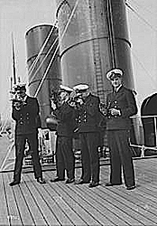
Cadets with sextants circa 1930 (from National Maritime Museum collections)

The "After Longitude" symposium covers what happened in between Harrison’s clocks and geospatial PNT. It is sponsored by the British National Maritime Museum and the Royal Institute of Navigation.

The event takes place on March 22 and 23 at the National Maritime Museum in Greenwich. 

Speakers on Thursday, March 22 will cover the earlier history of navigation. On Friday, topics include:

Read More >

By Inside GNSS
January 16, 2012

2012 International GPS/GNSS Showcase

The 2012 International GPS/GNSS Showcase will take place at Chulalongkorn University, Department of Survey Engineering, in Bangkok on January 17.

The event promotes cooperation and research on GPS and GNSS applications in the Asia Pacific region.

Read More >

By Inside GNSS

Galileo Application Congress Prague 2012

The Czech prime minister, Petr Nečas and Antonio Tajani, the European Commission vice president in charge of the Galileo program, will keynote this conference at the Prague Marriott Hotel on January 26-27, 2012.

The event celebrates the partnership between the Czech Republic and the European GNSS Agency (GSA) which will relocate from Brussels to Prague this year.

Read More >

By Inside GNSS
[uam_ad id="183541"]

FIG /IAG Technical Seminar: Reference Frame in Practice

Monte Mario, the highest hill in Rome

A special seminar for geodesists will take place in Rome, Italy on May 4 and 5, just before the 35th FIG general assembly and working week.

The conference venue is the Cavalieri hotel on Monte Mario near the Vatican.

It is organized by the International Association of Geodesy (IAG), the surveyors’ international association (FIG) and the UN’s International Committee on GNSS (ICG).

Read More >

By Inside GNSS

Hexagon 2012

A number of user conferences for customers of Hexagon AB’s precise measurement brands and products will be combined in the Swedish corporation’s second international conference this summer.

Read More >

By Inside GNSS

Advanced Receiver Processing of GNSS Signals: NavtechGPS

European Space Agency’s ESTEC in Noordwijk

NavtechGPS will offer a four-day public venue course from March 5 though 8 at the European Space Agency’s Space Research and Technology Center (ESA/ ESTEC) in Noordwijk, Netherlands.

"Advanced Receiver Processing of GNSS Signals" (Course 541) will be taught by John Betz, MITRE and James Sennott, Tracking and Imaging Systems, Inc.

Read More >

By Inside GNSS
January 14, 2012

2012 International Satellite Navigation Forum/ NAVITECH

Plenary session at a previous Satellite Navigation Forum.

The sixth International Satellite Navigation Forum will take place during the NAVITECH exhibition at the Expocentre Fairgrounds in Moscow, Russia on April 17 and 18, 2012.

The purpose of the forum is to discuss GLONASS and other GNSSes in the economy of Russia, developing commercial and civic uses for GLONASS, Russian national policy on the use of GLONASS, regional systems, new equipment and services and the development of single international standards in the field of satellite navigation.

Read More >

By Inside GNSS
[uam_ad id="183541"]

Code Tracking and Pseudoranges

FIGURE 2: Pseudorange computation based on transmission. On the left side, the satellites are transmitting mes¬sages synchronously. On the right side, the four subframes are received asynchronously, due to the different propagation time. The TLM word is taken as a referene. The time differences ?i are computed on the basis of the relative arrival times of the front of the first bit of the TLM word.

Q: How can pseudorange measurements be generated from code tracking?

A: Every GNSS receiver processes the received signals to obtain an estimate of the propagation time of the signal from the satellites to the receiver. These propagation times are then expressed in meters to solve for the user position using trilateration.

Read More >

By Inside GNSS

New Austerity Squeezes GPS as DoD Tightens Its Belt

Embracing the need for debt-driven discipline, the White House has revised its strategy for the nation’s defense, taking a more fiscally constrained approach that reduces the number of troops and future spending on defense systems.

The new plan, formally announced January 5, was already being put into effect last summer. “The strategic guid­ance was the compass by which we steered the budget review leading to the president’s budget for fiscal year ‘13 and the years thereafter,” Deputy Secretary of Defense Ashton B. Carter told reporters.

Read More >

By Dee Ann Divis

Contact!

A photo of the NavSAS group (December 2011)

On December 12, 2011, one of the two Galileo in-orbit validation (IOV) satellites launched on October 21 — the Galileo- ProtoFlight Model (PFM) spacecraft — started transmitting its payload signal on the E1 band over Europe.


That same day NavSAS researchers were able to acquire and track the E1 signal (Galileo Code Number 11) beginning at 14:46:15 CET. Two days later, on December 14, the E5 signal became available as well.

Read More >

By Inside GNSS

Winging It

FIGURE 1: Competitive group skydiving is currently judged by overlaying a grid on a photo and evaluating location of divers within its cells. Photo by Mark Harris.

»NovAtel Inc. wingsuit video

In 1589, at the age of 25, Galileo Galilei toiled up the 294 steps of a 55-meter bell tower in Pisa, Italy, where he was tutoring math students at the time.

According to his pupil and later biog­rapher, Vincenzo Viviani, Galileo carried with him two cannonballs, one twice the weight of the other. When he reached the top of the tower, he went to the lower balcony of the tilted structure and dropped the two balls simultaneously.

Read More >

By Inside GNSS
IGM_e-news_subscribe