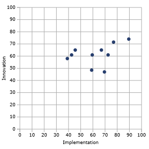
How does one compute the noise power to simulate real and complex GNSS signals?

Q: How does one compute the noise power to simulate real and complex GNSS signals?
By Inside GNSS
Q: How does one compute the noise power to simulate real and complex GNSS signals?
By Inside GNSSContemporary times have seen an increase in the number of navigation satellites across various geographical regions. In order to ensure that all these satellite systems work together to optimize the positioning, navigation, and timing (PNT) of users on or near the Earth’s surface there is need for inter-cooperation and inter-operability of the systems.
By Inside GNSSSecretary of the Air Force Deborah Lee James declared a critical Nunn-McCurdy breach on the GPS Next-Generation Operational Control System (OCX) today (June 30, 2016).
After a December 2015 Program “Deep Dive,” Undersecretary of Defense for Acquisition, Technology and Logistics Frank Kendall placed the OCX program under significant Department of Defense (DoD) oversight with quarterly reviews.
By Inside GNSS
South Monterey BayThe Institute Of Navigation (ION) annual technical meeting (ITM) will be held in conjunction with the Precise Time and Time Interval Meeting (PTTI) at the Hyatt Regency Monterey in Monterey, California on January 30 through February 2, 2017.
This year’s joint ITM/PTTI Plenary Session: Back to the Future: Forecasts for Time and Navigation, 1917 and 2017 will explore significant forecasts made in 1917 about time and navigation and relate them to the future as we envision it from 2017.
By Inside GNSS
The 2016 Trimble Dimensions user conference and exhibition will take place at the Venetian Hotel in Las Vegas on November 7, 8 and 9.
The annual event gathers users of Trimble’s products including positioning technology for unmanned systems as well as mapping, GIS, surveying, photgrammetry and remote sensing and other technologies of interest to readers of Inside GNSS.
Four hundred and fifty technical sessions and networking events give attendees an opportunity to network widely within and among industry groups.
By Inside GNSS
One of 12 magnetograms recorded at Greenwich Observatory during the Great Geomagnetic Storm of 1859
1996 soccer game in the Midwest, (Rick Dikeman image)
Nouméa ground station after the flood
A pencil and a coffee cup show the size of NASA’s teeny tiny PhoneSat
Bonus Hotspot: Naro Tartaruga AUV
Pacific lamprey spawning (photo by Jeremy Monroe, Fresh Waters Illustrated)
“Return of the Bucentaurn to the Molo on Ascension Day”, by (Giovanni Antonio Canal) Canaletto
The U.S. Naval Observatory Alternate Master Clock at 2nd Space Operations Squadron, Schriever AFB in Colorado. This photo was taken in January, 2006 during the addition of a leap second. The USNO master clocks control GPS timing. They are accurate to within one second every 20 million years (Satellites are so picky! Humans, on the other hand, just want to know if we’re too late for lunch) USAF photo by A1C Jason Ridder.
Detail of Compass/ BeiDou2 system diagram
Hotspot 6: Beluga A300 600ST

Electronic Throwaways, Space X Wins, Drones at Sea and Shaking It Up
By Inside GNSS
Dr. Inder Gupta, The Ohio State University
Chris Bartone, Ohio UniversityGNSS receivers seem to get all the attention. Go to any technical GNSS conference and the lion’s share of presentations are about receiver design and techniques: better algorithms, signal processing, integration with other sensors, spoofing detection, and on and on.
By Inside GNSS
A view of the Shenzhen Convention and Exhibition CenterThe 5th International Intelligent Transportation System and Location-based Services expo will take place in Shenzhen (深圳), China on June 17, 18 and 19, 2016. It will take place in Hall 9 of the Shenzhen Convention and Exhibition Center in the city center.
By Inside GNSS
Main auditorium, Strathclyde Conference CentreThe Royal Institute of Navigation’s International Navigation Conference 2016 will be held at the University of Strathclyde Conference Centre in Glasgow, Scotland from November 8 – 10, 2016.
A number of keynote speakers will discuss topics from Virgin Galactic’s voyage to space to quantum sensors for inertial navigation to autonomous cars, android phones, train control and even "Three dimensional thinking: from rats to humans, via Klingons."
Poster and demonstration abstracts are due by May 30. Full paper submission is due on June 15.
By Inside GNSS
ESTEC interiorNAVITEC is an annual navigation conference hosted by the European Space Agency (ESA). This year’s event will take place at ESA’s Space Research and Technology Center (ESTEC) in Noordwijk, Netherlands on December 14, 15 and 16, 2016. The theme is "Navigating the Future of Transportation."
The scope of the workshop includes navigation equipment and techniques, including receivers, payloads, signals, navigation algorithms, signal processing techniques and terrestrial and space GNSS applications.
By Inside GNSSSo, if everything had gone as planned, we would have a new ground control segment (OCX) operating a new generation of satellites (GPS III) as they launch into an expanded constellation in support of modernized military GPS user equipment (MGUE).
But then the best-laid plans. . . .
By Inside GNSSAdvanced military receivers using the sort of modern multi-channel, multi-constellation capabilities already available commercially, could enable the Air Force to focus its anti-jam efforts on the ground, simplifying future GPS satellites and lowering their cost. Moreover, experts told Inside GNSS, the cutting-edge receivers could be deployed years before the anti-jam capability planned for the new GPS III satellites would be fully available.
By Dee Ann Divis
Symbols and AcronymsModernized GPS satellites give civil users the ability to achieve dual L1/L2 PY accuracy using dual L1CA/L2C ionosphere-free measurements and, with IIF satellites, dual L1/L5 signals. Because broadcast GPS ephemeris data is based on an ionosphere-free pseudorange calculated from dual L1PY/L2PY measurements and the civil signals are not all perfectly aligned to it, new broadcast parameters and a new modernized dual-frequency algorithm are needed in order to align new signals with the dual L1/L2 PY signal.
By Inside GNSS