integration/integrated system Archives - Page 7 of 9 - Inside GNSS - Global Navigation Satellite Systems Engineering, Policy, and Design

integration/integrated system

March 24, 2009

OnPOZ Offers Free ArcPad GNSS Driver Extension

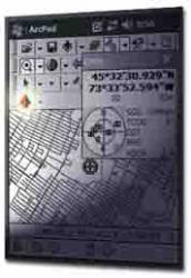
Montreal, Quebec, Canada–based OnPOZ Precision Positioning has released, GNSS Driver for ArcPad, a new extension to the ESRI product that allows GNSS post-processing using different GNSS receiver brands.

The receiver-independent extension can significantly improve GNSS/GIS data accuracy and reliability, logging real-time positions, metadata, and all GNSS observations in order to increase the reliability and accuracy of GNSS positions by post-processing ESRI Shapefiles.

Read More >

By Inside GNSS
February 17, 2009

CSR-SiRF Merger Pairs Struggling Bluetooth and GPS Powerhouses – and Shows Handset Platform Dominance

CSR image

Merger plans recently announced by CSR (Cambridge Silicon Radio) plc and SiRF Technology Inc. connote more than the evolving fortunes and common future of a Cambridge, UK–based Bluetooth and WiFi provider and a San Jose, California GPS manufacturer.

It reaffirms the emergence of mobile phone handsets as a dominant location platform, the convergence of wireless communications and positioning at the chip level, and the trend toward absorption by semiconductor manufacturers of independent GPS technology providers who offer only single-frequency solutions.

Read More >

By Glen Gibbons
[uam_ad id="183541"]
January 6, 2009

PCTEL Acquires Wi-Sys

PCTEL, Inc., announced today (January 5) that it has acquired Wi-Sys Communications Inc., an Ottawa, Ontario, Canada–based company that specializes in GPS antenna and receiver technology. PCTEL will pay $2.1 million for Wi-Sys and plans to fully integrate the latter company’s operations into its Antenna Products Group (APG).

Read More >

By Glen Gibbons
December 7, 2008

NovAtel Announces GNSS Smart Antenna for Machine Guidance

NovAtel has announced its new SMART-AG antenna, an L1 GPS + GLONASS receiver plus antenna system housed in a single, low profile, rugged enclosure, designed for manual guidance and auto steer installations.

SMART-AG features 14 GPS L1 channels, 12 GLONASS L1 channels, and two additional channels for satellite-based augmentation systems (SBAS) as well as two NMEA 0183 compatible RS-232 serial ports, an NMEA2000 compatible CAN port, plus built-in mounting magnets.

Read More >

By Inside GNSS
August 26, 2008

Xsens MTi-G AHRS Chosen for DoD Vehicles

Fairfax, Virginia–based defense contractor ArgonST has selected the MTi-G GPS-aided Attitude & Heading Reference System (AHRS) from Xsens Technologies, of Enschede, The Netherlands, to help fill a U.S. government contract for a new generation of reference motion trackers for use on a variety of air and ground vehicles.

Read More >

By Glen Gibbons
[uam_ad id="183541"]
August 15, 2008

Sunny and Hot! A perfect month for a solar car race

Continuum soaks up the rays in Sioux Falls, South Dakota.

A sleek-looking solar car built by a University of Michigan team was first across the finish line early in the afternoon of July 22 after a long, hot 10-day 2,400-mile (4,000 km) race from Plano, Texas to Calgary, Alberta. And once again GPS and satellite-based differential corrections play a key role.

This year, 15 solar-powered cars built by students from universities in the U.S., Canada, and Germany completed the 2008 North American Solar challenge.

Michigan has won five out of nine NASC races, held every other year since 1990.

Read More >

By Inside GNSS
August 13, 2008

ATK PGK Trials Meet 105mm Artillery Standard

IEC’s TruTrak Evolution GPS Receiver

Alliant Techsystems Inc. (ATK) has announced its successful demonstration of the capability to divert a 105-millimeter (105mm) artillery round using its existing 155mm Precision Guidance Kit (PGK) with minimal modification to the current design.

Read More >

By Glen Gibbons

Applanix Adds Camera, LIDAR Options to Its DSS 439 RapidOrtho Airborne Mapping System

Applanix DSS 439 System

Applanix has launched a dual-camera version of its Digital Sensor System (DSS) 439 RapidOrtho airborne mapping solution and introduced full LIDAR integration options for fixed wing and helicopter installations.

The DSS 439 RapidOrtho DualCam produces a directly georeferenced, four-band ortho-imagery in a single pass, according to the company. The new product offering adds a second DSS camera with a monochromatic charge-coupled device (CCD) array specifically configured to capture near infrared (NIR) imagery.

Read More >

By Glen Gibbons
May 26, 2008

Xsens Offers SW/HW Upgrades for AHRS/GPS Products

MT Manager

Xsens Technologies B.V. has announced the release of a new version of the MT Software Development Kit (SDK) and new firmware for all of the Enschede, The Netherlands¬based company’s inertial motion trackers: MTi, MTi-G and MTx.

The software and firmware contain predefined settings for optimized orientation output in several specific application areas. Applications relying on data output for orientation, stabilization, or navigation will benefit.

Read More >

By Glen Gibbons
IGM_e-news_subscribe