commercial Archives - Page 2 of 9 - Inside GNSS - Global Navigation Satellite Systems Engineering, Policy, and Design

commercial

May 26, 2015

GNSS Hotspots | May 2015

One of 12 magnetograms recorded at Greenwich Observatory during the Great Geomagnetic Storm of 1859
1996 soccer game in the Midwest, (Rick Dikeman image)
Nouméa ground station after the flood
A pencil and a coffee cup show the size of NASA’s teeny tiny PhoneSat
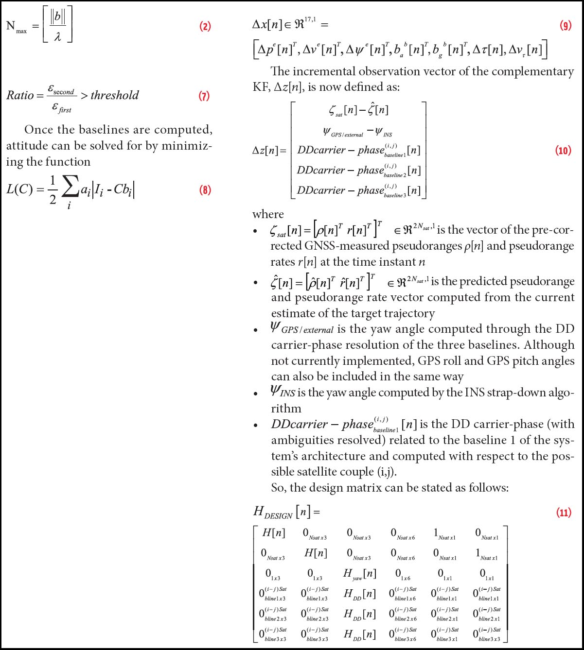
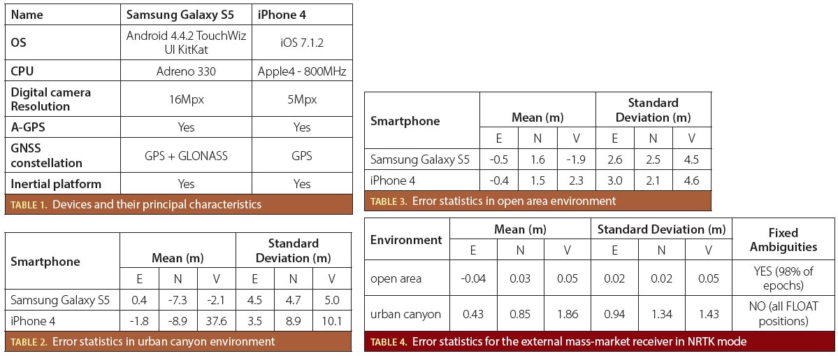
Bonus Hotspot: Naro Tartaruga AUV
Pacific lamprey spawning (photo by Jeremy Monroe, Fresh Waters Illustrated)
“Return of the Bucentaurn to the Molo on Ascension Day”, by (Giovanni Antonio Canal) Canaletto
The U.S. Naval Observatory Alternate Master Clock at 2nd Space Operations Squadron, Schriever AFB in Colorado. This photo was taken in January, 2006 during the addition of a leap second. The USNO master clocks control GPS timing. They are accurate to within one second every 20 million years (Satellites are so picky! Humans, on the other hand, just want to know if we’re too late for lunch) USAF photo by A1C Jason Ridder.
Detail of Compass/ BeiDou2 system diagram
Hotspot 6: Beluga A300 600ST

1. DISPOSABLE DRONES
Washington, D.C.

Read More >

By Inside GNSS

Still Not a Thing, Part 2

One of the first feature articles I wrote as a newly minted GNSS magazine editor 26 years ago was about an advanced rail traffic management system based on GPS that Burlington Northern, with the help of Rockwell Collins, had designed and implemented.

Read More >

By Inside GNSS
[uam_ad id="183541"]
May 20, 2015

Thinking Small

Equations 2, 7, 8, 9, 10 & 11

Unmanned aerial vehicles (UAV) are finding increased application in both domestic and governmental applications. Small UAVs (maximum take off weight less than 20 kilograms) comprise the category of the smallest and lightest platforms that also fly at lower altitudes (under less than 150 meters).

Designs for this class of device have focused on creating UAVs that can operate in urban canyons or even inside buildings, fly along hallways, and carry listening and recording devices, transmitters, or miniature TV cameras.

Read More >

By Inside GNSS
March 20, 2015

Flying Blind

It’s 10 p.m. somewhere over the vast oceans that comprise three-quarters of the Earth’s surface. Do you know where your airplane is?

Well, you could, but maybe you don’t.

The anniversary of the disappearance of Malaysia Airlines flight MH370 came and went in March with the fate of the Boeing 777 still unknown.

It didn’t have to happen.

Read More >

By Inside GNSS
January 25, 2014

UN Symposium: Commercial Applications of Global Navigation Satellite Systems

Vienna, Austria

The Symposium to Strengthen the Partnership with Industry will be held on Monday, February 17, during the second week of the fifty-first session of the Scientific and Technical Subcommittee of the United Nations Committee on the Peaceful Uses of Outer Space, and will happen in parallel to the planning meeting to the Ninth Meeting of ICG and its Providers’ Forum, at the Vienna International Centre in Vienna, Austria.

Read More >

By Inside GNSS
[uam_ad id="183541"]
December 18, 2012

Meet the New European GNSS Agency: Much the Same, Only Different

Coming nearly full circle and yet ending up in a new place with a new name describes the peculiar fortunes of the European GNSS Agency, an unlikely fate perhaps reflected most clearly in its continued use of its predecessor’s acronym, GSA.

Five years ago when Europe’s GNSS program abandoned its seemingly misconceived and now roundly condemned effort to forge a public-private partnership (PPP) to develop Galileo, the original GSA — the Galileo Supervisory Authority — appeared orphaned, bereft of purpose and patrons.

Read More >

By Inside GNSS
December 11, 2012

London Conference Beats Drum for Galileo Acceptance

The accompanying figure shows the acquisition results of the FM3 Galileo satellite (PRN 11) E1b data channel, as computed by the NAVigation Signal Analysis and Simulation (NavSAS) group of the Politecnico di Torino/Istituto Superiore Mario Boella (ISMB) in Italy. The upper plot shows the search space along ±7 kHz Doppler frequency, while the lower one shows the search space along 4 millisecond code delay. The coherent integration time used to obtain this search space was 4 milliseconds, coupled with 11 noncoherent accumulations.

The third Galileo in-orbit validation (IOV) satellite, also known as Flight Model 3 (FM), began transmitting signals last week, and the FM4 spacecraft, like the FM3 launched on October 12, is expected to come on-line soon — providing the theoretical capability of 3D positioning using solely satellites of Europe’s GNSS system.

Read More >

By Inside GNSS
October 29, 2012

Indoor Navigation Smartphone App wins 2012 Galileo Masters Prize

Presentation of the 2012 €20,000 Galileo Master prize: (L to R)) Thorsten Rudolph, head of AZO, the contest organizers; Carlo des Dorides, head of the European GNSS Agency; winner Dirk Elias, Fraunhofer Portigal and Ulrike Daniels, AZO business development. (photo: Simone Hörmann/AZO).
The 2012 ESNC awards ceremony at der Residenz, Munich (AZO photo)

Finding your way will be even easier with a new smartphone app from two Portuguese research institutes that augments GNSS with ultra-low magnetic field communication (ULF-MC) for reliable navigation in office buildings, airports, underground parking garages and other indoor locations.

Read More >

By Inside GNSS
September 20, 2012

What’s Happening at ION GNSS 2012

ION GNSS 2012 ienjoyed clear skies and warm temperatures at the Nashville Convention Center in Tennessee. The U.S. Institute of Navigation-sponsored venerable conference closed on Friday, September 21. 

Thursday’s workshops featured expanded discussion on China’s Compass/Beidou-2 and Europe’s  Galileo. Two more Beidou MEO satellites were launched during the conference for a total of 15. Meanwhile, Europe plans an October 10 launch that will bring the total to four. Speakers "guaranteed a 30 satellite constellation by 2020."

Read More >

By Inside GNSS
August 17, 2012

PNT Advisory Board Seeks Details on Economic Benefits of GPS

To help counter pressures from federal budget cutters and wireless advocates searching for more broadband spectrum, the National Space-Based Positioning, Navigation, and Timing (PNT) Advisory Board is crafting a study documenting the economic benefits of GPS.

“We have a new assignment . . . to discover and disclose the economic contributions of the Global Positioning System,” Chairman Jim Schlesinger told the board at an August 15, 1012 meeting of the advisory board.

Read More >

By Dee Ann Divis
IGM_e-news_subscribe