Global Navigation Satellite Systems Engineering, Policy, and Design
Global Navigation Satellite Systems Engineering, Policy, and Design
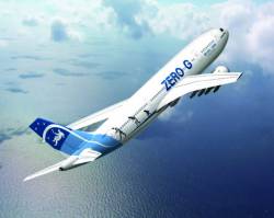 Airbus A300 Zero G (CNES photo)
Operational requirements for second-generation emergency location terminal (ELT) beacons have raised the possibility of activating a beacon during flight. This represents a major change in the use of a Cospas-Sarsat distress beacon.
In October 2012 CNES conducted an experiment to verify the possibility of detecting and locating an ELT beacon activated in flight. As the final specifications for second-generation beacons were not defined at that time, a flexible first-generation beacon was used.
By Inside GNSS
Return to main article: "Tracking IRNSS Satellites"
By Inside GNSSEvery so often, anthropologists — and maybe a few mathematicians — have a field day puzzling over the origins of our positional base-10 numeral system.
Oh, not the historical origins themselves, the Hindu-Arabic innovations beginning in the 5th and 6th centuries. That’s all pretty much agreed.
No, I’m referring to the possible physiological inspirations, the readily visible digits at the ends of our limbs: 10 fingers, 10 toes.
Coincidence? Does nature have coincidents, or does it abhor them like vacuums — o horror vacui?
By Inside GNSS
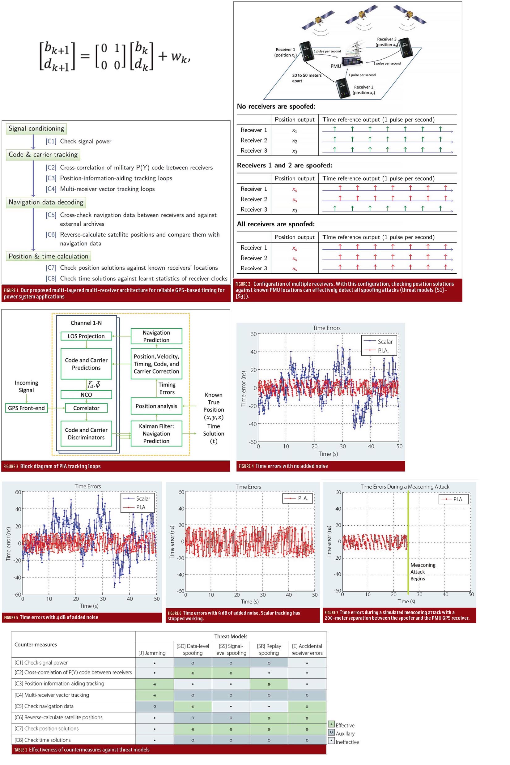
Efficient power transmission and distribution would benefit from synchronized near–real-time measurements of voltage and current phasors at widely dispersed locations in an electric power grid. Such measurements also could enable effective real-time system monitoring and control, which are considered to be the key to preventing wide-scale cascading outages like the 2003 Northeast Blackout.
By Inside GNSS
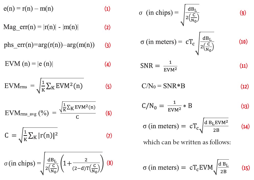
As a navigation satellite transmits multiple signals on single frequency (e.g., Open Service and Restricted Service over L5 Band), these are combined on a common carrier to comprise a composite signal. This composite signal passes through navigation payload subsystems such as an up-converter, traveling wave tube amplifier (TWTA), filters, and so on. These subsystems may introduce adverse effects on the signal, such as amplitude and phase distortion, nonlinear effects, gain imbalance, IQ imbalance, and phase noise.
By Inside GNSS
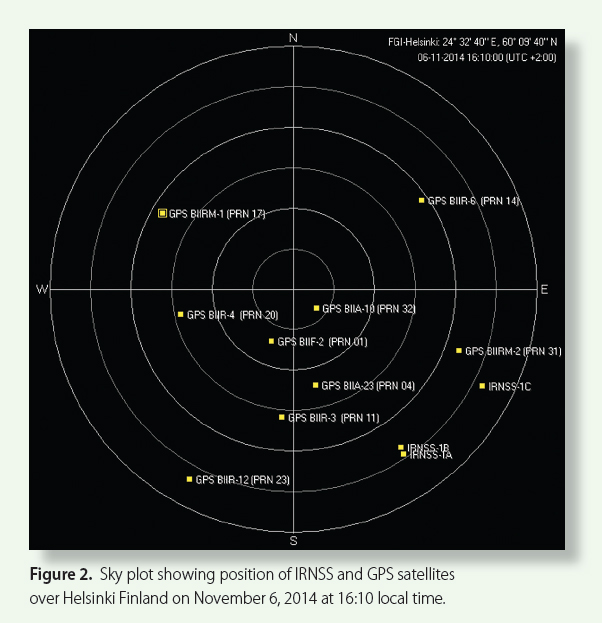 Figure 2: Sky plot showing position of IRNSS and GPS satellites over Helsinki Finland on November 6, 2014 at 16:10 local time.
The Indian Regional Navigation Satellite System (IRNSS)] is designed as a stand-alone regional navigation system with a primary service area extending up to 1,500 kilometers from the Indian land mass. Finland lies north of 60°N latitude more than 5,000 kilometers away from India, as shown in Figure 1 (see photo at the top of this article).
By Inside GNSS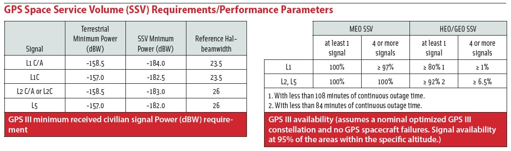 GPS Space Service Volume (SSV) Requirements/Performance Parameters
New space missions such as the robotic repair and recovery of damaged or errant communication satellites may become possible with the aid of an emerging class of receivers that is able to use GPS signals for navigation in orbits thousands of kilometers above the middle Earth orbit (MEO) GPS constellation itself.
By Dee Ann Divis
