Japan’s Quasi-Zenith Satellite System (QZSS) launched a replacement for its first satellite, Michibiki-1, on October 26. QZS-1R, to be known as Michibiki-1R, flew up on a Mitsubishi Heavy Industries rocket and all went smoothly.
After an upgrade of the global Galileo Control Segment to Version 3.0, next month’s satellite launch will be the first overseen from an existing Galileo Control Centre, rather than requiring an external mission control site.
Northrop Grumman PNT experts are using artificial intelligence (AI) and machine learning (ML) to develop new software to combat jamming and spoofing threats to navigation systems in contested battlefield environments.
A new software from RUAG Space for its GNSS receivers makes it possible to determine the position of a satellite in orbit ten times more accurately, down to 10 centimeters, according to the company. The more precise the satellite position, the more accurate its data, for example about climate and weather prediction. Better satellite navigation also helps to avoid space debris and will be important in the upcoming deployment of hundreds, perhaps thousands of small low-Earth orbit satellites.
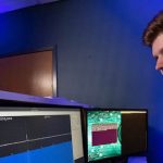
RUAG Space recently conducted its first software tests on Earth. This involved testing a new software with an existing navigation receiver for satellites under simulated space conditions. “The result was impressive,” said Anders Linder, Senior Vice President Program Satellites at RUAG Space. “We were able to determine the satellite’s real-time position ten times more accurately than previously possible.” Position accuracy improved from about 100 centimeters to 10 centimeters. “This is a quantum leap in high-precision satellite positioning.”
[Image above: Copernicus: Sentinel-1 — The SAR Imaging Constellation for Land and Ocean Services. Courtesy European Space Agency.]
The higher accuracy was achieved with a new software program. To determine the exact position of satellites in orbit, RUAG Space’s latest navigation receivers use Galileo and GPS signals. “There is currently untapped potential in the Galileo satellites,” explained Anders Linder. Galileo satellites transmit several signals. On one of these signals, a new service, the High Accuracy Service (HAS), will enable significantly improved positioning. This service will be available in 2022.
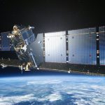
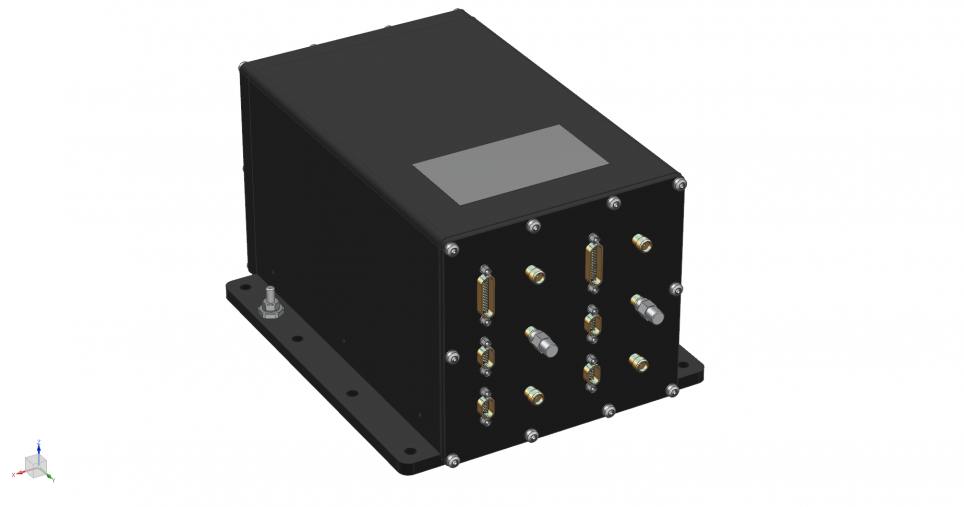
“A software update can be played on navigation receivers already in space as well as receivers we have already delivered to customers and which are still on Earth,” said Linder. The hardware of the devices remains unchanged. RUAG Space for example already delivered the GNSS receiver PODRIX for ESA’s Sentinel-1C environmental satellite. The European Space Agency (ESA) is having its satellite upgraded with this new software for in-orbit validation of the satellite. The Sentinel-1C satellite is scheduled for launch in 2022.
The following comes from a paper by Heinz Reichinger at RUAG Space. A full technical article will appear in an upcoming issue of Inside GNSS.
“High-accuracy positioning of satellites in orbit has seen a lot of improvement in the recent years. Centimeter-level accuracy is still the domain of Precise Orbit Determination (POD), which is a post-processing algorithm with time delays between several hours and several days, depending on the required accuracy level. Precise Point Positioning (PPP) techniques allow to come close to POD accuracies with expected accuracies in the range of 10 cm but have the big advantage of being available in real-time. Thus, the real-time accuracy increases from currently 1 meter to as precise as 10 cm, resulting in a 10x times more precise real-time determination of the satellite’s position in orbit.
“PPP in space relies on highly accurate GNSS satellite (clock and orbit) correction data, which needs to be available in real-time and with global coverage. Such a real-time and global correction data service for the Galileo and GPS constellations provided by Galileo as part of its High Accuracy Service (HAS) on the E6 signal has already been tested and is planned to become operational in 2022.
“RUAG Space is developing PPP software utilizing the Galileo HAS for its “PODRIX” GNSS receivers for Low Earth Orbit applications. ESA has awarded a contract to RUAG Space to deliver this PPP software for upgrading the PODRIX GNSS receiver already delivered to Thales Alenia Space for integration on the Sentinel 1C satellite. The PPP performance of the receiver will be demonstrated during the in-orbit validation phase of Sentinel 1C, which is set for launch in 2022. Further developments/improvement of the PODRIX GNSS receiver are expected to be endorsed with the completion of the project NEWSPAPER receiving funding from the European Union Agency for the Space Programme (EUSPA) supporting the evolution of the PPP software.
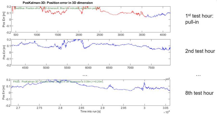
“The figure below shows PPP performance test results of the PODRIX GNSS receiver. The tests have been performed with a satellite signal simulator and flight-representative hardware. Based on RUAG Space’s experience with highly accurate GNSS receivers for space applications, this performance is expected to be actually reached in orbit.”
PPP performance test results of the PODRIX GNSS receiver. Courtesy RUAG Space
New Nav for Satellite Swarms
In the coming years, the launch of many satellite swarms of hundreds to thousands of small satellites in low-Earth orbit is planned. For such swarms of identical satellites, RUAG Space is developing a low-cost navigation receiver that is lighter and smaller than conventional GNSS receivers and already includes the new software with processing of the Galileo signal HAS as standard. The new space-borne receiver called NavRix PinPoint is more cost-effective due to the use of standardized electronic components.
NavRIX Pinpoint, courtesy RUAG Space.
At the beginning of 2021, the Prague-based European Union Space Programme Agency awarded a research contract to RUAG Space. The aim of the study is to increase the positioning accuracy of satellites. The study will be completed in 2022.
The Air Force Research Laboratory (AFRL) awarded a $49.7 million contract to KBR Inc. for the Stealth & Cognitive Agile Navigation System (SCANS) project, researching and prototyping an alternative position, navigation, and timing (PNT) system for use in GPS-denied environments.
The European Commission (EC), the European Space Agency (ESA) and the European Union Agency for the Space Programme (EUSPA) have set up a Joint Office within the EC’s headquarters in Brussels to help manage and develop Galileo, Europe’s GNSS.
Saab, the Swedish defense and security company, and Maxar recently demonstrated a solution to GPS-denied environments by integrating Maxar’s 3D DATA and Precision 3D Registration (P3DR) technology into the Gripen E, the combat fighter jet
The European satellite service provider (ESSP) placed Charlotte Neyret, former European Development Director for Thales Alenia Space, at its helm as chief executive officer.ESSP manages EGNOS, the European GNSS satellite-based augmentation system.
The U.S. Army has put its replacement for the handheld Defense Advanced GPS Receiver (DAGR) under field testing in reconnaissance and fire missions in a variety of threat scenarios, to understand its performance in a realistic operational environment. The Dismounted Assured Positioning, Navigation, and Timing System (DAPS) could enable warfighters to better shoot, move and communicate in a GPS degraded environment.
Russia’s state space agency Roscosmos will start placing ground stations for its GLONASS navigation satellite system across China, tentatively before the end of the year, announced Roscosmos Deputy Director for International Cooperation General Sergey Saveliev.
The U.S. Army Research Lab awarded the University of Central Florida a $4.5 million grant to develop a smart, computer vision-based navigation system for when GPS is unavailable or jammed.