
March 20, 2025
Space Force Presses on with R-GPS Constellation
An update on where we are with Resilient GPS, an additional network of smaller, cheaper navigation satellites that would augment existing GPS satellites.
By Brett DavisGlobal Navigation Satellite Systems Engineering, Policy, and Design
An update on where we are with Resilient GPS, an additional network of smaller, cheaper navigation satellites that would augment existing GPS satellites.
By Brett Davis
The Defense Innovation Unit’s (DIU’s) Transition of Quantum Sensing (TQS) program will demonstrate the military utility of quantum sensors to address strategic Joint Force competencies like positioning, navigation, and timing (PNT), as well as anomaly detection.
By Inside GNSS
Adtran has announced that the Turin and Piedmont Internet Exchange (TOP-IX) has launched Italy’s first time-as-a-service (TaaS) solution using Adtran Oscilloquartz technology. Delivered in collaboration with Italy’s National Institute of Metrological Research and other strategic partners, the service leverages Oscilloquartz edge grandmaster devices deployed across TOP-IX’s dedicated fiber network.
By Inside GNSS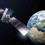
The European Union Agency for the Space Programme (EUSPA) has awarded GMV a new framework contract for the evolution of the Galileo Reference Centre (GRC). The mission of the GRC is to carry out independent monitoring of the Galileo system, providing EUSPA with reports on its operation, the quality of navigation signals transmitted, and the performance of the services obtained at user level.
By Inside GNSS
Xona Space Systems, a provider of advanced commercial satellite navigation solutions announces a new collaboration with Trimble, a global leader in construction, transportation and geospatial technology. Xona and Trimble are pursuing the integration of Trimble correction services with Xona’s PULSAR™ high-performance navigation service.
By Inside GNSS
The Federal Communications Commission (FCC) has issued a draft Notice of Inquiry (NOI) that, if adopted, will seek input on the development of alternative Positioning, Navigation, and Timing (PNT) technologies to complement GPS.
By Inside GNSS
The Air Force Life Cycle Management Center (AFLCMC) Positioning, Navigation, and Timing (PNT) Program Office and Integrated Solutions for Systems (IS4S), in collaboration with AEVEX Aerospace, announce the successful completion of Alternative Positioning, Navigation, and Timing (PNT) flight tests for the Resilient-Embedded GPS/INS (R-EGI) Modular Open Systems Architecture (MOSA).
By Inside GNSS
Project Manager Positioning, Navigation and Timing’s (PM PNT’s) Mounted PNT product office has received full-rate production (FRP) approval of its Mounted Assured, Positioning, Navigation and Timing System (MAPS) Generation (GEN) II from Program Executive Office Intelligence, Electronic Warfare and Sensors (PEO IEW&S).
By Inside GNSS
Xona Space Systems, a developer of a high-performance complementary alternative to GPS, announced that it has secured a contract with Air Force Research Lab (AFRL) to demonstrate and mature resilient commercial PNT (Positioning, Navigation and Timing) solutions for DoD missions.
By Inside GNSS
Editor’s Note: Jon Damush, uAvionix CEO, provides context on existing technological safeguards that can help prevent aircraft collisions like the one near Washington, DC on Jan 29.
By Jon Damush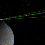
On February 19th, the receiver successfully acquired and tracked signals from GPS and Galileo satellites in lunar orbit, at 63 Earth radii, approximately 401,814 kilometers from Earth.
By Inside GNSS
To drive the development of optical positioning, navigation and timing (PNT) technology, the European Space Agency (ESA) has signed a contract with a consortium of companies that will conduct a definition study (Phase A/B1) and associated critical technology predevelopment.
By Inside GNSS
Zephr.xyz, a provider of augmented position, navigation, and timing (AugPNT) technologies, has been awarded a $1.74 million Small Business Innovation Research (SBIR) Direct-to-Phase II contract from the Air Force Research Laboratory (AFRL) to develop real-time detection of GNSS jamming and spoofing in contested domains while geolocating the sources of these attacks.
By Inside GNSS