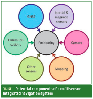
A: System Categories Archives - Page 156 of 199 - Inside GNSS - Global Navigation Satellite Systems Engineering, Policy, and Design

A: System Categories

FY11 Budget Battle Over, GPS Looks Ahead to FY12

Resolution of the between Congressional Republicans and Democrats that threatened a shutdown of the federal government has clarified the picture for military GPS programs in the coming year, although prospects for the civil side remain uncertain.

On April 15, 2011, President Obama signed the Department of Defense and Full-Year Continuing Appropriations Act, 2011 (H.R. 1473, Public Law 112-10), the last in a series of government-wide funding measures for Fiscal Year 2011 (FY11).

Read More >

By Inside GNSS
April 26, 2011

10 High School Teams to Test Robots at the Smithsonian in the 2011 Mini Urban Challenge

Pace High School “Catastrophic” team, the 2010 winner

Ten Lego kits transformed into autonomous robotic vehicles will gather, with their high school student masters, on Saturday, May 21 at the Smithsonian for the 2011 national championship of the Institute of Navigation Mini-Urban Challenge.

It all happens from 8 a.m. to 5 p.m. in the Spark!Lab and first floor of the Lemelson Center for the Study of Invention and Innovation on the National Mall.

Read More >

By Inside GNSS
April 23, 2011

GPS-Guided Honeywell MAV Aids in Japan Nuclear Plant Emergency

T-Hawk MAV. Honeywell photo

A GPS-guided T-Hawk Micro Air Vehicle (MAV) more frequently used in combat reconnaissance missions in Iraq and Afghanistan is being used to help emergency efforts at Japan’s damaged fukushima Daiichi nuclear plant.

Weighing just 17 pounds and measuring 14 inches in diameter, the T-Hawk is a ducted-fan vertical takeoff and landing air vehicle originally developed in recent years by Honeywell Corporation under a $40-million Defense Advanced Research Projects Agency (DARPA) technology demonstration contract.

Read More >

By Inside GNSS
[uam_ad id="183541"]
April 18, 2011

Modernization Times

Enterprise Baseline Schedule

Col. Bernie Gruber, commander of the GPS Directorate since June 2010, works in a busy place.

Through its various incarnations since being established in 1974 — as Joint Program Office, Air Force Wing, and now Directorate — the GPS program at the Space and Missile Systems Center (SMC), Los Angeles Air Force Base, California, has been at the center of the action.

Read More >

By Inside GNSS
[uam_ad id="183541"]

Geneq Announced Dual-Frequency RTK GPS, OmniSTAR HP Receivers

Geneq SXBlue IIIL

Geneq Inc., a Montreal, Quebec, Canada, manufacturer, has introduced two new GPS products.

The SXBlue III-L is a compact GPS L1/L2 receiver in the world designed for use with OmniSTAR’s HP service to attain decimeter accuracy worldwide. Targeted at GIS mapping/surveying applications, the receiver measures 14 x 8 x 5.6 centimeters (5.57 x 3.15 x 2.22 inches) and weighs 517 grams (1.14 pounds) including battery.

Read More >

By Inside GNSS
April 9, 2011

Hey, Kids! Get Your Names on Europe’s Galileo Satellites!

If you are lucky enough to be nine to eleven years old and living in Belgium or Bulgaria, you could get your name on one of the first European navigation satellites.

Two of them will launch from French Guiana in September 2011. Although Europe already has test satellites in the sky, these launches will mark the beginning of Galileo, a global navigation satellite system much like GPS.

Read More >

By Inside GNSS
April 7, 2011

Hexagon 2011 International Conference

A number of user conferences for customers of Hexagon AB’s precise measurement brands and products will be combined in the Swedish corporation’s first international conference this summer.

It will take place at Orlando World Center Marriott Resort in Orlando, Florida from June 6 through June 9, 2011.

The theme is "Building a Smarter World," and will include 200 technical and training sessions and an industry exhibition.

Read More >

By Inside GNSS
March 31, 2011

GPS ‘Stewards’ DoD, DoT DepSecs Protest LightSquared Plan to FCC

John Porcari, Dep. Secretary of Transportation. DoT photo

In a letter to Federal Communications Commission Chairman Julius Genachowski, the second-ranking officials from the U.S. departments of defense (DoD) and transportation (DoT) have issued the strongest administration message yet regarding LightSquared’s proposal to build a network of high-powered terrestrial transmitters broadcasting near the GPS L1 and other GNSS frequencies.

Read More >

By Inside GNSS
March 30, 2011

Army Fields GPS-Guided Mortar in Afghanistan

GPS-guided APMI mortar in the field. U.S. Army photo

U.S. soldiers in Afghanistan are the first Army combat units to have access to GPS-guided 120-millimeter mortar cartridge capability — a rapidly fielded capability that has put precision guidance into a still-smaller military form factor.

The Program Executive Office (PEO) for Ammunition at Picatinny Arsenal, New Jersey, fielded the Accelerated Precision Mortar Initiative (APMI) cartridges to an infantry brigade combat team (IBCT) earlier this month, and is scheduled to field cartridges to the seven other IBCTs in Afghanistan within six months.

Read More >

By Inside GNSS
IGM_e-news_subscribe