Main Categories

August 2, 2010

Topcon Releases Software for IP

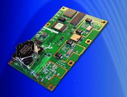
Topcon Positioning Systems (TPS) has announced the release of Spatial Factory software.

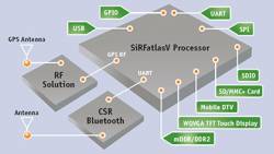
The software interface allows users to work with the combination of point cloud, trajectory, and panoramic image data that comes from the Topcon IP-S2 3D mobile mapping system.

Read More >

By Inside GNSS

Hemisphere Launches GPS Vector II OEM Board

Hemisphere GPS has announced its Crescent Vector II OEM board and a series of related Crescent Vector II GPS compass products.

The new OEM board, targeted for system integrators, brings a series of new features to the company’s patented Crescent receiver technology, including heave, pitch, and roll output; more accurate timing, lower phase noise, and an improved accelerometer.

The Crescent Vector II design provides precise heading and positioning accuracy even while a mobile platform is motionless.

Read More >

By Inside GNSS
[uam_ad id="183541"]
August 1, 2010

50th Civil GPS Service Interface Committee (CGSIC) Meeting

The 50th Civil GPS Service Interface Committee (CGSIC) Meeting will be held on Monday, September 20 and Tuesday, September 21 at the Oregon Convention Center in Portland just before the 2010 Institute of Navigation GNSS conference at the same location.

For the first time, the CGSIC meeting will be hosted by ION and the CGSIC plenary session will be on the main agenda of the larger conference.

CGSIC subcommittee meetings will be held on Monday and the plenary session on Tuesday, a reversal of the usual order.

Read More >

By Inside GNSS

China Launches 5th Compass (Beidou-2) Navigation Satellite — First IGSO

Fifth Beidou-2 satellite launched. Xinhua/Du Cai photo

[Updated August 1, 2010] China’s state news agency has reported that the fifth Compass (Beidou-2) satellite — the system’s first inclined geostationary orbit (IGSO) spacecraft — was launched successfully at 5:30 a.m. Sunday (August 1 — local time) from Xichang Satellite Launch Center in southwestern Sichuan Province

This was the third Compass satellite put into orbit this year, following launches in June and January 2010.

Read More >

By Inside GNSS

China Launches 4th BeiDou Navigational Satellite

A Compass/Beidou-2 geostationary satellite is lifted into space from China’s Xichang space center. (China Academy of Launch Vehicle Technology photo)

[Reprinted with permission from NAVIBIZ, Issue Date: 2010-6-18]

At 23:53 on June 2, China successfully launched the 4th BeiDou navigational satellite into the pre-designated orbit with the "Long March 3C" carrier rocket at the Xichang Satellite Launch Center, symbolizing that China has made another important step forward in building the BeiDou (COMPASS) Navigation Satellite System. The construction of COMPASS follows the principles of openness, independency, compatibility, and gradualness.

Read More >

By Inside GNSS
[uam_ad id="183541"]

China Approves License for 18 Mapping Services — AutoNavi Included, Google Unlikely Choice

[Reprinted with permission from NAVIBIZ, Issue Date: 2010-7-2]

Late in May, China implemented new standards aimed at preventing "state secrets being disclosed and uncertified maps published online." A major component to this push was a requirement that all online mapping services are operated with a license. The first 18 companies, of the ones that applied for a license, have been approved.

Read More >

By Inside GNSS

Latest Updates on Satellite Navigation — Only at NaviForum Shanghai 2010

[Reprinted with permission from NAVIBIZ, Issue Date: 2010-7-23]

On June 2, China successfully launched the fourth BeiDou navigation satellite into the pre-designated orbit, symbolizing that China has made another important step forward in building the BeiDou (COMPASS) Navigation Satellite System. As is known to all, satellite navigation and positioning system is the key strategic infrastructure for information, and it will influence the process of social civilization and change people’s ideas about life, time and space.

Read More >

By Inside GNSS

GPS-Aided Test Flight Lowers Emissions by 35 Percent in Alaska Airlines “Greener Skies” Project

Alaska Air graphic

Alaska Airlines demonstrated next-generation GPS-aided flight procedures last week (July 23) during a test flight over Puget Sound, Washington, that burned less fuel and reduced emissions by 35 percent compared to a conventional landing.

The flight was part of Alaska Air Group’s “Greener Skies” project at Seattle-Tacoma International Airport (Sea-Tac) focused on using satellite-based guidance technology to fly more efficient landing procedures that will reduce environmental impacts in the region.

Read More >

By Inside GNSS
July 27, 2010

GNSS Simulators

FIGURE 1: GNSS multi-channel signal simulator 10 years ago on its own (left) and with its ever-growing family (right)

For the complete story, including figures, graphs, and images, please download the PDF of the article, above.

In this article we describe the design and operation of a generic GNSS RF simulator. We also will look at the main types of GNSS RF simulators, their designs and specifics, their advantages and disadvantages.

Read More >

By Inside GNSS

Meet GINA

GINA On-Board Unit (OBU)

For at least the past two decades, managing traffic on Europe’s road networks has been a growing concern for European policy makers and citizens alike. While demand for transport has consistently increased over the years, Europe’s road network capacity has failed to keep pace, leading to increasing levels of congestion and pollution.

Read More >

By Inside GNSS
IGM_e-news_subscribe