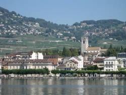
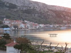
Galileo Archives - Page 53 of 71 - Inside GNSS - Global Navigation Satellite Systems Engineering, Policy, and Design

Galileo

June 8, 2012

New Navigator Seminar

Business School, University of Nottingham Jubilee Campus

The Royal Institute of Navigation will hold a new navigator seminar and networking opportunity at the University of Nottingham on June 14, 2012 for new navigators, engineers, scientists and surveyors who are seeking careers in the industry.

Masters and doctoral level students will present on navigation and positioning topics, advanced undergraduates and postdocs will be in attendance. A number of industry and government representatives will exhibit or attend to listen to new research and meet the new talent.

Read More >

By Inside GNSS
May 27, 2012

IP Rights and Wrongs

As Desi Arnaz often said to Lucille Ball during an “I Love Lucy” episode on TV, “You’ve got some ’splaining to do.”

I refer, of course, to the untoward and unexpected initiative by the British Ministry of Defense (MoD) to patent the technical innovations that underlie the planned next generation of civil GNSS signals.

Read More >

By Dee Ann Divis
[uam_ad id="183541"]
May 26, 2012

Stanford and Aalborg Announce Summer Workshop on GNSS Positioning for the Future

A number of GNSS experts from the United States, Denmark, Norway and China will lead a weeklong workshop on the future of satellite-based positioning technologies from August 27 through September 2 at the Slettestrand Holiday Center in North Jutland, Denmark.

The topics range from GNSS basics and Intelligent Transportation Systems to new GNSSes, new receivers and indoor navigation as well as environmental monitoring and arctic navigation. The event is organized by Stanford and Aalborg universities.

Read More >

By Inside GNSS
May 24, 2012

How do GNSS-derived heights differ from other height systems?

FIGURE 2: Example of a national geoid (upper diagram) and a correction surface for the transformation from the new orthometric height system to the old height system (lower diagram). Country is Switzerland. Geoid undulations range from 45 to 55 meters in ETRS89 and from -5 to +5 meters in the national System CH1903+. Lower diagram: Correction surface to transform from the new orthometric height system (LHN95) to the old height system LN02 with corrections from -0.10 to 0.55 meters.

Q: How do GNSS-derived heights differ from other height systems?

A: Height estimation using GNSS always seems to be trickier than horizontal coordinate estimation.

Why?

On the one hand, the GNSS technique has error sources that are more critical in the vertical direction. Height estimates are weaker because of a combination of satellite geometry, the presence of strong correlations to other parameters, such as atmospheric delays, and the antenna phase center model applied during data analysis.

Read More >

By Inside GNSS
[uam_ad id="183541"]
May 23, 2012

Inertial Sensors and Systems 2012

An afternoon at the 2011 symposium

The Inertial Sensors and Systems symposium will take place at the Karlsruhe Institute of Technology in Karlsruhe, Germany on September 18 and 19, 2012. The conference will be held in English.

At this conference, formerly the Symposium Gyro Technology, the latest state of inertial sensors and navigation systems as well as gyro technology will be presented.

This includes applications of this technology, the development of new systems, components and test procedures as well as investigations on cost and marketing aspects.

Read More >

By Inside GNSS

COSPAR 2012: Committee on Space Research Scientific Assembly

Ceremonial room in the Mysore Palace, now a public museum.

The 39th scientific assembly of COSPAR, the Committee On Space Research, willl take place from July 14 to July 22, 2012 at the Global Education Centre-2, Infosys Training Centre, Mysore, Karnataka, India. Mysore is known as the "City of Palaces."

The topics are fundmentals and relevance of space science and technological innovations and applications. Of particular interest to readers of Inside GNSS are sessions on atomic clocks, space weather, space debris, satellite dynamic and the ionosphere.

Read More >

By Inside GNSS

SIRGAS 2012

Calle peatonal Lota Bajo (Photo: Jorge González)

SIRGAS 2012, the annual working meeting of the organization in charge of the geocentric reference system for the Americas, will be held at the Universidad de Concepción auditorium in Concepción, Chile October 29 through 31, 2012.

The event will also be hosted by the Instituto Geográfico Militar of Chile.

In addition to the meeting sessions, a technical visit to the Transportable Integrated Geodetic Observatory (TIGO) of the German Federal Agency for Cartography and Geodesy (BKG) is scheduled.

Read More >

By Inside GNSS
May 22, 2012

IEEE ICRA 2013: International Conference on Robotics and Automation

The Pyramid, a Karlsruhe landmark

IEEE’s giant robotics conference comes to Karlsruhe, Germany in 2013, with the theme "Anthropomatics-Technologies for Humans."

The event will take place at the Karlsruhe convention center (Knogresszentrum Karlsruhe) on May 6-10, 2013.

The conference covers every possible aspect of robotics development from body form and movement, programming and learning, hardware and software to lots of positioning, navigation and timing aspects.

Read More >

By Inside GNSS

Conference on New Trends and Applications of GNSS

Billed as the "First International Conference" on new trends and applications of GNSS, this new event is sponsored and organized by the Space Science Center at Cairo University.

It will take place at Cairo University in Giza city from September 1 to 4 2012. The conference language is English.

Paper abstracts are due by July 15, midnight Cairo Standard Time. Submit them online at the website below.

With more services and signals, the GNSS landscape is changing and new trends and applications must be considered.

Read More >

By Inside GNSS
1 51 52 53 54 55 71
IGM_e-news_subscribe