
Building assured PNT for the fight we are actually in.
Electronic warfare is reshaping the PNT problem on today’s battlefield. Jamming, spoofing, meaconing and sustained RF pressure are now part of the operational reality that warfighters must plan for and operate through. The war in Ukraine has made that reality highly visible, with each new reported incident reinforcing the same point: the threat is no longer episodic or theoretical. It is an operational condition that is likely to persist and expand.
That reality has senior officials across the Department of War (DoW) urgently looking for practical solutions, with growing emphasis on getting advanced, modernized military GPS capabilities such as M-Code more widely fielded. The objective is not to abandon GPS. It is to strengthen it.
MODERN MILITARY GPS VS. LEGACY SYSTEMS
Even in this new landscape, military GPS remains the most mature and protected source of precision, absolute PNT available to authorized users, said Luke Bishop, Product Line Director at BAE Systems. The right response is not to replace GPS, but to field modern military GPS, protect it, toughen it and augment it with additional sensors that can fill specific mission gaps.
“People are worried that GPS doesn’t work anymore and that we have to find an alternative,” BAE Ground Products Portfolio Director Zack Hamilton said. “The GPS capabilities they’ve enjoyed for the last 40 years is still what they want—absolute, precise PNT—they just want it to work all the time, even inside a threat environment.”
The lesson is not that GPS has lost its relevance. The lesson is that assured PNT must start with the most protected form of GPS available to the warfighter, then build outward through anti-jam, anti-spoof, integrity monitoring and mission-specific complementary sensors.
Some describe the current challenge as a GPS-denied problem, but that characterization can be too broad and too simplistic. “GPS denied” is not a requirement; it is a condition that must be defined. What kind of jamming? What level of spoofing? What platform? What altitude? What mission duration? What SWaP-C limit? What level of integrity is required? Without that specificity, platforms risk treating very different PNT problems as though they are the same.
It is also important to remember that GPS user equipment is not created equal. Many publicly discussed examples of GPS failure in contested environments involve unaided commercial GPS, legacy systems or insufficiently hardened architectures—not modern military GPS protected by M-Code, anti-jam/anti-spoof capability and complementary sensors. Many civil solutions used in contested environments do not provide the same level of protection, authentication or threat-informed hardening as modern military GPS.
The same distinction applies inside the military GPS community. Legacy Selective Availability Anti-Spoofing Module (SAASM) equipment is not the same as modern M-Code systems with advanced anti-jam and anti-spoof protection and increased cyber resilience.
“It’s important to understand a lot of the platforms and systems out there today have yet to be upgraded to M-Code or the most cutting-edge anti-jam technology,” Bishop said. “People see some of these performance challenges out in the field and they draw incorrect conclusions and therefore assume these challenges apply to all user equipment configurations.”
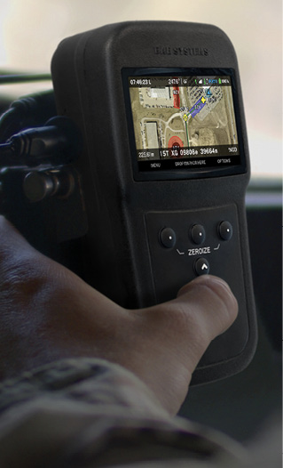
For years, BAE Systems has built hardened military GPS solutions with M-Code as the primary PNT source, supplementing that core capability with what Bishop described as “world class anti-jam and anti-spoof.” Though adoption remains a challenge, M-Code solutions and complementary APNT architectures are available today. The issue is not whether the capability exists. It is how quickly the defense community can move through integration, certification and fielding pathways to get that capability into warfighters’ hands.
M-Code is ready. This is a fielding problem.
“By maximizing the protection of M-Code, system designers can focus on lower cost sensors for the complementary parts of PNT,” Bishop said. “So, it brings the overall system cost down and gives system designers the ability to tailor solutions to the needs of each mission and platform.”
MILITARY GPS REMAINS THE APNT FOUNDATION
Military GPS remains indispensable because it provides precise absolute position (World Geodetic Survey 1984 (WGS84), precise time (Coordinated Universal Time (UTC), global availability and decades of threat-informed hardening. It is also a capability that many current military personnel have relied on throughout their entire careers. To operate successfully in the contested environments warfighters now face, DoW must more widely field systems equipped to handle the modernized M-Code signal, then toughen that military GPS layer with anti-jam/anti-spoof and augment it with other sensors in layered, mission-specific APNT architectures.
There are few sensors that provide absolute position, said Matt Bousselot, a technical fellow in PNT at BAE Systems, and absolute time is even more difficult. That makes military GPS especially compelling. APNT is not a choice between “GPS” and “alternatives.” Military GPS provides the trusted core; complementary sensors fill specific mission gaps.
There is also no signal, Bousselot said, that has been as thoroughly toughened, protected and hardened as military GPS.
“We’ve had multiple decades of dealing in the threat mitigation business,” Bousselot said, “so we have countermeasures to those threats, and countermeasures to the countermeasures that have been built into the user equipment for the last 20, 30 years.”
When new signals come online, he said, it is not just the signal in space that matters. It is also the user equipment development that has happened around that signal to counter evolving threats. Military GPS has benefited from decades of operational feedback, technical iteration and threat-specific mitigation. That is difficult for newer signals or sensor approaches to replicate quickly.
That distinction is central to the current APNT debate. Modern military GPS is not static. It continues to evolve as users encounter new threat conditions and feed those lessons back into the system. Contested GPS performance is not a reason to move away from GPS. It is a reason to continue improving and fielding the most protected GPS user equipment available.
“Right now,” Bousselot said, “GPS is easily the primary in any PNT PACE plan.”
LAYERED APNT, NOT SINGLE-SENSOR REPLACEMENT
There is no magic bullet, and there is no one-size-fits-all solution. The EW threat will not be solved with one untoughened sensor, one alternative technology or one universal replacement for GPS.
Inertial sensors, clocks, RF alternatives, vision navigation and emerging technologies all play important roles. Each can add value in the right context. But each also has weaknesses and limitations. When it comes to providing absolute precision time and position, Hamilton said, “GPS is easily the toughest thing going.”
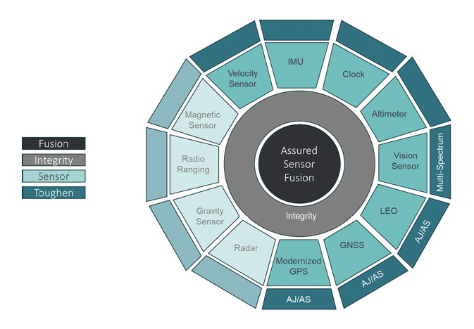
To achieve APNT resilience, the solution must be a mission-driven architecture built around complementary, not alternative, PNT. Military GPS remains the foundation. Other sensors are selected and integrated based on the mission, the threat environment, the platform and the level of trust required. GPS and other sensors degrade for different reasons, which is precisely why they must be combined intelligently.
“It’s not about GPS versus something else,” Bishop said. “It’s about the right blend. And if I can toughen GPS sufficiently, I can save money on these other sensors that go with it. It may not be wise to invest huge dollars into a vis nav-only solution that has its own weaknesses. The focus should be on creating an APNT system that gets me the best cost per successful mission.”
That idea—cost per successful mission—is important because the real measure of an APNT architecture is not the unit cost of any individual sensor. It is whether the complete system can complete the mission in the threat environment it is expected to face.
An inexpensive system that fails in the intended environment is not a low-cost solution. Likewise, an exquisite sensor that exceeds the mission need may drive unnecessary cost and complexity. The APNT challenge is to match the solution to the mission, the threat and the platform.
Mission success is what matters. It does not help to deploy an inexpensive system that is ineffective in the environment where it is expected to operate, Bishop said. Solutions must be tailored to the mission and the EW environment.
By strengthening the core GPS layer, M-Code can reduce the burden placed on other sensors and help control total system cost. It can also allow designers to use complementary sensors more selectively and more intelligently, rather than trying to force any one sensor to solve the entire navigation problem.
For example, upgrading to a modernized GPS receiver and anti-jam antenna in an APNT system substantially reduces the area of impact for electronic threats to GPS. This reduces the amount of time the system must rely on alternate, contingency and emergency methods of navigation, and enables the use of much lower cost alternate sensors to achieve mission success. The cost reduction of alternate sensors often more than offsets the cost of the upgrade.
So, the question is not which sensor replaces GPS. The question is which architecture gives the mission the highest confidence of success.
INTEGRITY: VERIFY, DO NOT JUST FUSE
Adding sensors is not enough. The APNT system must know which inputs are trustworthy, when they are degrading and how much confidence should be assigned to them. That is especially critical in contested environments, where a sensor can continue producing data even when that data is compromised, degraded or misleading.
The central issue is not simply availability. It is trust.
In an effort to improve availability, many systems look to additional signals and sensors. But redundancy does not automatically create integrity. Additional sensors improve the solution only if the system understands when and how to trust them.
“What we worry about when we start pulling other signals into our solution is how can we trust them,” Bousselot said. “It’s actually possible to bring other signals into an M-Code based solution that make the entire system less effective for the mission because those signals were added in a way that isn’t trustworthy.”
Additional signals must either be protected to the level the military GPS signal is protected, Bousselot said, or their limitations must be understood so they can be incorporated “in a smart way.”
Integrity is a top priority for customers. In many cases, users would rather have no solution than a solution they cannot trust. That is why sensor credibility must be verified, not simply fused into the navigation solution.
With its Integrity Ring concept, BAE Systems does not simply fuse data from multiple sensors. Each sensor’s input is actively evaluated before being included in the final PNT solution. If a sensor begins to diverge from the consensus or behave inconsistently with the expected mission environment, it can be excluded or weighted differently. Mike Shepherd, Director of APNT Strategy at BAE’s Navigation and Sensor System’s Business, has likened the concept to a courtroom: each sensor provides testimony, and the integrity function serves as the judge.
This allows for multi-sensor PNT integrity, which means available signals and sensors can be used while maintaining high trust in the final PNT solution.
But customers cannot afford to put the most premium solution on every platform, Bousselot said, so integrity also must scale. As with anti-jam performance, there is always a trade-off around integrity, SWaP-C and mission need. A baseline level of integrity comes with modern military GPS user equipment, but higher levels of integrity and anti-spoofing capability can require additional processing, hardware or system complexity.
That means customers must make choices around cost versus performance even as it relates to integrity.
“Some of the interactions we’ve had with customers and potential partners recently have been, how do we relay the information to them as to what level of integrity they’re getting so they can make good decisions on that data,” Bousselot said, “versus just trying to get them the best integrity that exists, which may not be able to fit on their platform.”
That nuance matters. Not every platform needs or can afford the most exquisite APNT suite. But every platform needs an architecture appropriate to its mission, threat environment and trust requirements. Integrity must be engineered into that architecture from the start.
M-CODE FIELDING URGENCY
Relying on legacy systems or insufficiently protected PNT architectures increases risk for warfighters operating in contested environments. The message is direct: M-Code is ready. This is a fielding problem.
The issue is not whether modernized military GPS capability exists. The issue is how quickly program offices, integrators and platform owners can move through integration, qualification, adoption and fielding pathways.
M-Code adds important protections, but adoption has lagged threat environment demands. There has been movement, however. Senior DoW leaders increasingly recognize the urgency of fielding M-Code and reducing reliance on waivers or legacy approaches that leave platforms without the most modern military GPS capability available.
To push M-Code adoption forward, program offices must distinguish between availability, obsolescence and fielding timelines. One issue the market raises involves concern about supply availability and whether programs should wait for later technology increments. Fieldable M-Code solutions are available now, and waiting can become its own source of operational risk.
M-Code is available across domains. BAE Systems is already shipping M-Code solutions for ground, weapons and airborne applications. This is not primarily an availability or production-capacity issue. It is a matter of accelerating platform integration, adoption and fielding.
There is also a perception challenge. Recent GAO reporting on GPS modernization, for example, has focused on the progress of M-Code capable user equipment in Programs of Record (POR), Bishop said. That is an important piece of the puzzle, but it is not the whole picture. Industry has also moved forward with commercial M-Code solutions that are available today and ready for authorized users outside of PORs.
A casual reader of modernization reporting could come away with the impression that the M-Code universe is limited to a small number of formal program-of-record products, Bishop said, when the actual set of industry-developed capabilities is broader.
“Don’t just focus on the Programs of Record,” Bishop said. “When you think about M-Code, focus on what the industry has come forward with as a whole.”
This is where the current moment becomes urgent. The threat environment has changed. The operational need is visible. The technology is ready. The industrial base exists. The next challenge is fielding.
LESSONS FROM WEAPONS—AND IMPLICATIONS FOR UAS
Precision weapons have long had to operate in severe threat environments under extreme SWaP-C constraints. As a result, the weapons community has already matured around architectures that protect military GPS, toughen it with anti-jam and anti-spoof capability, and augment it with inertial sensing to achieve precise absolute PNT.
That history matters because weapons have been forced to solve the problem many other platforms are now confronting. They have had to operate in contested environments, under severe size, weight, power and cost pressure, while still delivering the mission outcome.
Weapons, Shepherd said, show the value of M-Code-centered APNT in some of the hardest operating environments. The weapons community understands M-Code as a core capability for reaching targets with high accuracy, and it has leaned heavily into military GPS protection, anti-jam/anti-spoof toughening and inertial augmentation.
The lessons learned are increasingly relevant to small UAS and launched effects, which face many similar constraints: contested environments, high-volume production, rapid design cycles, mission consequences and severe SWaP-C pressure.
Small UAS and launched effects may have more to learn from the weapons community than from traditional aviation modernization models. Manned aviation follows a different and often slower modernization path because of long aircraft life cycles, certification requirements, safety considerations, block upgrade structures and the cost of modifying large installed fleets.
“They’re likely not going to ground an airplane and send it back to the depot just for an M-Code upgrade,” Bishop said. “It will be part of block upgrades. So, there’s that reality of how the aircraft lifecycle works, versus I’m going to build a new munition instead of retrofitting an existing one. It’s just a very different model on how the fielding occurs.”
When aircraft updates are made, there is often a focus on provisioning as much as possible for future agility, Bishop said. That can work against SWaP-C goals and add complexity to the problem, making airborne modernization different from weapons or smaller UAS markets.
There is also a class of aircraft, he said, that must address additional safety-of-life requirements, adding more complexity and feeding into the broader system safety architecture. The cost and complexity of safety certification can slow adoption, and can encourage programs to bundle many requirements into larger modernization efforts rather than fielding a single capability quickly.
Small UAS and launched effects are different. Their design cycles are shorter. Their SWaP-C constraints are more severe. Their production tempo is faster. Their architectures can evolve more rapidly. In many ways, they resemble the weapons market more than the manned aircraft market.
That creates both a risk and an opportunity. If UAS developers treat GPS as a fragile commercial input or assume that alternative sensors can replace a protected military GPS core, they may under-equip their systems for the threat environments they will face. If they learn from the weapons community, however, they can build around M-Code protection, anti-jam/anti-spoof toughening, integrity and mission-specific augmentation from the start.
“This is still an emerging, young market and I feel like they could learn a lot of lessons from the weapons space,” Hamilton said. “Drone manufacturers are under equipping their PNT systems right now and we believe, over time, they will mature and adopt a lot of similar technologies to include M-Code with proper AJ and the right kind of augmentation.”
The point is not to dismiss other sensors or emerging approaches. Vision navigation, inertial sensing, timing technologies and other complementary capabilities all have a role. The point is that those technologies should be integrated into a trusted APNT architecture, not treated as universal replacements for GPS.
Integrating M-Code into small UAS and launched effects early in the design cycle can help manufacturers bring more mission-capable systems to the warfighter. Because those design cycles more closely resemble munitions than manned aircraft, and because they share similar SWaP-C constraints that the weapons community has already confronted, the opportunity to apply those lessons is immediate.
SCALE, INSERTION AND INDUSTRIAL READINESS
M-Code GPS-based APNT is no longer only a future concept problem. It is a fielding and architecture discipline problem that can be acted on today. BAE Systems is positioned to scale to meet demand without requiring significant new capital investment. As Bishop put it, “We’re ready to go.”
That readiness is partly the result of BAE Systems’ broad customer footprint, Bishop said, and the market cycles the company is already set up to support. BAE Systems also describes its military GPS business as operating with a commercial-style investment model, giving the company flexibility to move quickly, invest ahead of demand and support customer needs on relevant timelines.
“It’s very much a commercial business where we invest, we take the risk,” he said. “That incentivizes us to drive efficiencies and compete more on commercial terms.”
In many traditional government contracting models, vendors wait until after receiving a contract to invest in materials from the supply chain. BAE Systems often leans forward, buying materials well in advance of the contract award. That approach gives the company a level of agility more commonly associated with commercial markets—an approach that aligns with DoW’s increasing interest in speed, scalability and fieldable capability.
That is the way BAE Systems Navigation & Sensor Systems product line has operated for years, Bishop said, giving the company the ability to “surge and get these products done on a relevant timeline.” The Cedar Rapids facility represents a mature military GPS production base, and that production foundation positions the company to support fielding at scale.
“We’ve been asked in every senior leader meeting, if we surge, if we come to you and say we’re going to buy two to three times above what we normally do, is there any investment we need to provide to you to expand your facility,” Shepherd said. “There’s no investment. We can scale. We’re set up to do that.”
The same fielding logic applies to integration. Backward-compatible and lower-burden insertion paths are central to accelerating adoption, and BAE Systems has made that a key focus. The goal is to reduce integration pain wherever possible, especially for platforms that need modernized military GPS capability quickly.
“You’re going to disconnect, pull the old one out, put the new one in,” Shepherd said. “The same cable, the same antenna. We think about that pain, and then we try to take it away.”
That does not mean every integration challenge disappears. Certification, platform-specific requirements and program timing still matter. But modernization does not always have to be treated as a distant, bespoke, high-friction upgrade. In many cases, practical insertion paths exist today.
KEEPING UP WITH THE THREAT
Slogans, single sensors and delayed modernization will not solve the APNT challenge. Nor will treating GPS and resilience as opposing ideas. PNT starts by fielding the most protected military GPS layer available (M-Code), then building around it with anti-jam, anti-spoof, integrity monitoring and mission-specific complementary sensors.
Replacing GPS with so-called alternative solutions is not the answer. The stronger approach is to field hardened military GPS and incorporate the right complementary sensors to fill the remaining gaps.
“When you start trying to do worldwide precision absolute navigation and timing with anything besides GPS, the job gets really, really hard,” Hamilton said. “What GPS brings to the table in our APNT model is it reduces their problem set to a small space where, in the worst conditions, GPS, or maybe toughened GPS, needs some help, but now they have to solve a half a mile or a mile or a five mile problem, not a 25,000 mile problem.”
That idea captures the practical value of military GPS-centered APNT. GPS does not have to solve every problem alone. But when protected and integrated properly, it reduces the size of the problem other sensors must solve. It gives the architecture a trusted foundation. It narrows the gaps. It helps bound error. It gives complementary sensors a more realistic role.
Layered architectures are understood. Integrity principles are mature. One APNT architecture, with M-Code at its core, can scale across domains, with the sensor mix varying by mission and platform. The technology is there and ready to be leveraged.
M-Code is ready. This is a fielding problem.
The task now is to field modern military GPS-based APNT at the speed and scale the threat environment demands. And like Bishop said, BAE Systems is ready for it.


