GNSS interference is no longer a distant concern or a technical edge case. As jamming, spoofing and autonomy requirements expose the limits of today’s PNT architectures, LEO is emerging as one of the most important alternatives to understand.
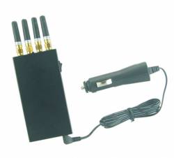
Attacks on GNSS are no longer simply a nuisance or a trivial disruption we can afford to ignore. Spoofing and jamming have become increasingly widespread, driving economic losses and costing lives, both in military operations and in civilian settings. Now, more than ever, we need to look closely at backup and complementary solutions that can fill the voids when GNSS falls short.
I recognize this may come across as cliché; however, in this case, it is not. The threat is real. The urgency is real. And the consequences of inaction are becoming harder to ignore.
Low Earth orbit, or LEO, positioning, navigation and timing (PNT) may be one of the most important answers. Commercial companies are creating mega-constellations to harness the many advantages of LEO, and it has become clear that LEO satellites could play a major role in future PNT architectures. In some applications, LEO could complement GNSS. In others, it may provide a space-based alternative when GNSS is degraded, manipulated or denied altogether. There is a lot of interest and excitement around LEO in the industry, and for good reason. It is an emerging area that many of us are studying with intensity and enthusiasm. But there are different schools of thought on how best to leverage LEO PNT, and the path forward comes with its own technical, operational, commercial and regulatory challenges.
That is why this column is born and will exist in every edition.
Inside LEO will explore how LEO systems are reshaping PNT, communications, resilience and the broader architecture of space based services. LEO is not just another orbit. It changes the signal environment, the economics, the business model and, potentially, the way users think about trust in PNT.
But let’s be clear: LEO PNT is not a new, revolutionary concept. In fact, the first satellite navigation system, Transit, was a LEO system developed in the 1960s. Through Transit, we learned that LEO PNT is both a blessing and a curse.
It is a blessing because of speed, geometry and signal strength. LEO satellites are closer to Earth and move quickly across the sky. Those characteristics can be extremely useful for navigation. But LEO is also a curse because it requires a large number of satellites to provide persistent, useful coverage. During the Transit era, users often had to wait an hour or more to get a position fix. That was not exactly ideal then, and it is certainly not acceptable for the world we live in today.
To address the LEO curse, we needed a very large number of satellites, which was not feasible given launch capabilities in the 1960s. That is why GPS quickly became the dominant PNT system. A medium Earth orbit (MEO) architecture, where GPS operates, achieves comparable performance with an order-of-magnitude fewer satellites than would be needed in LEO. GPS’s design mitigated the problem of slow position fixes while still delivering high accuracy and continuous global coverage. Yes, GPS had limitations, particularly in urban canyons and indoors, but those were limitations users could often live with or augment using localized sensors.
For decades, GPS and then GNSS were enough for many applications.
In an ideal world, it might have stayed that way. But times have changed. GNSS alone is no longer enough.
The Emergence of LEO PNT
Two things happened simultaneously and independently: the rapid development of autonomous systems and continuous, escalating attacks on GNSS. Autonomous platforms exposed the limits of GPS alone in safety critical, dynamic environments. At the same time, spoofing and jamming became easier, more accessible and more prevalent, both in military theaters and in civilian life.
The PNT community realized something had to change. The search for complementary and backup solutions became urgent. LEO PNT emerged as one of the most intriguing options.
Although satellites started to launch into LEO in significant numbers in the late 1990s, interest in LEO PNT did not really accelerate until around 2017 or 2018. That was when Starlink announced plans to put nearly 12,000 satellites into LEO. This was significant because, at the time, there were not even close to 12,000 satellites in all of LEO combined.
Many people thought that target number was wishful thinking. I took it seriously and started studying LEO PNT with existing constellations [1].
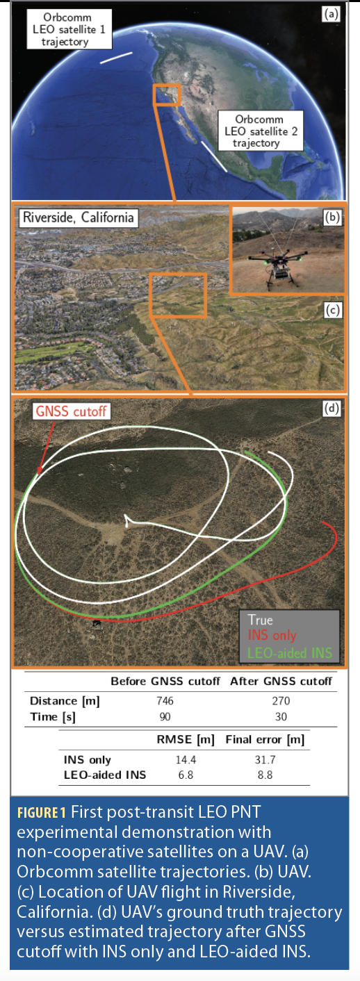
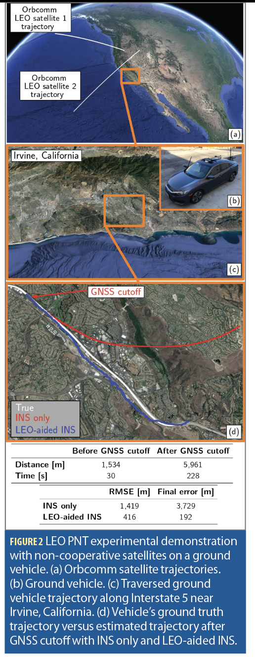
My lab started with Orbcomm satellites and developed the simultaneous tracking and navigation (STAN) approach to address their poorly known signal, ephemerides and timing [2, 3]. In 2018, we conducted the first post-Transit LEO PNT experimental demonstration with non-cooperative satellites, where we navigated an unmanned aerial vehicle (UAV) by exploiting Orbcomm LEO signals of opportunity. We experienced first hand experimentally the curse that had plagued LEO in the past. Our navigation solution began to degrade after about 30 seconds (Figure 1) [4]. We also drove a vehicle in Southern California for a few kilometers. The errors were on the order of hundreds of meters (Figure 2) [1].
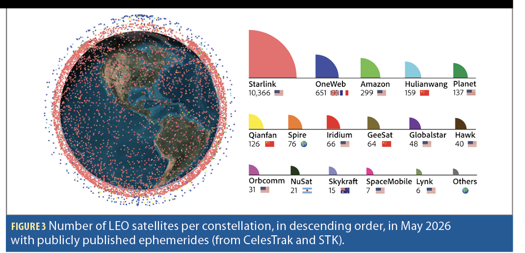
So, yes, LEO can give you a navigation solution. But with sparse constellations and limited observability, it is not necessarily accurate enough for many modern applications. That changes when you add satellites. Many satellites (Figure 3).
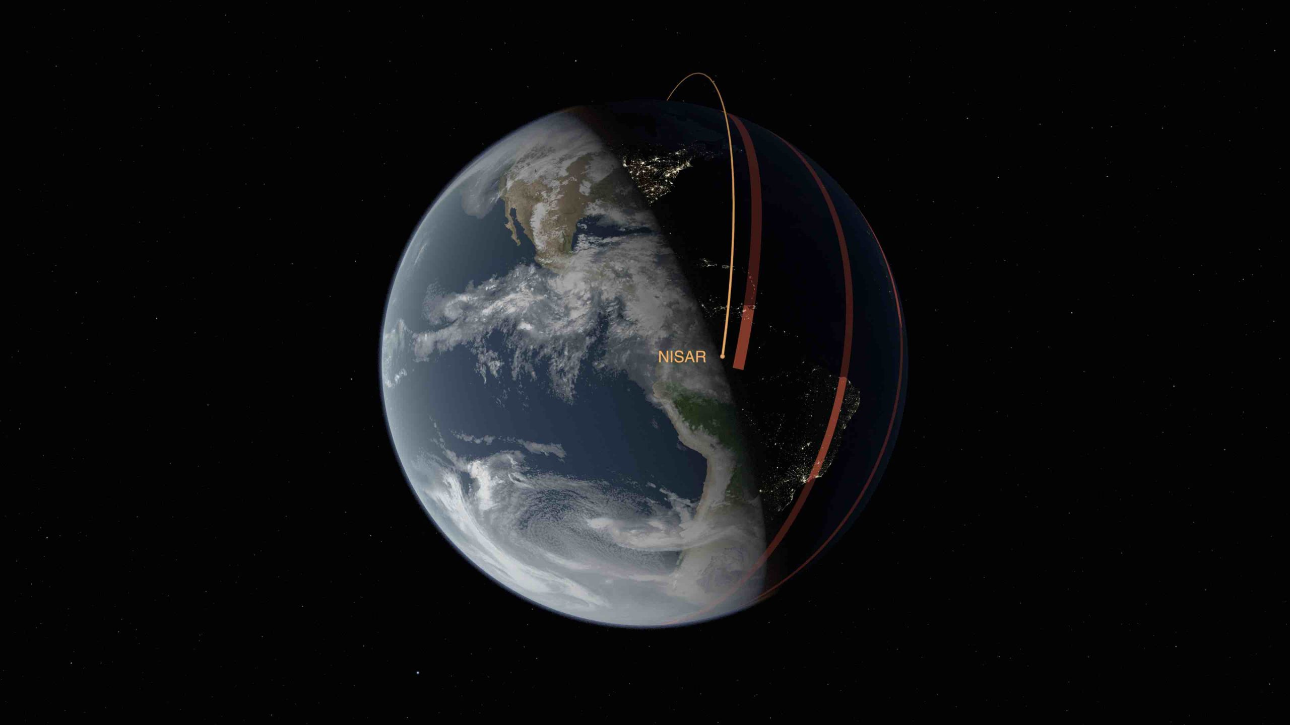
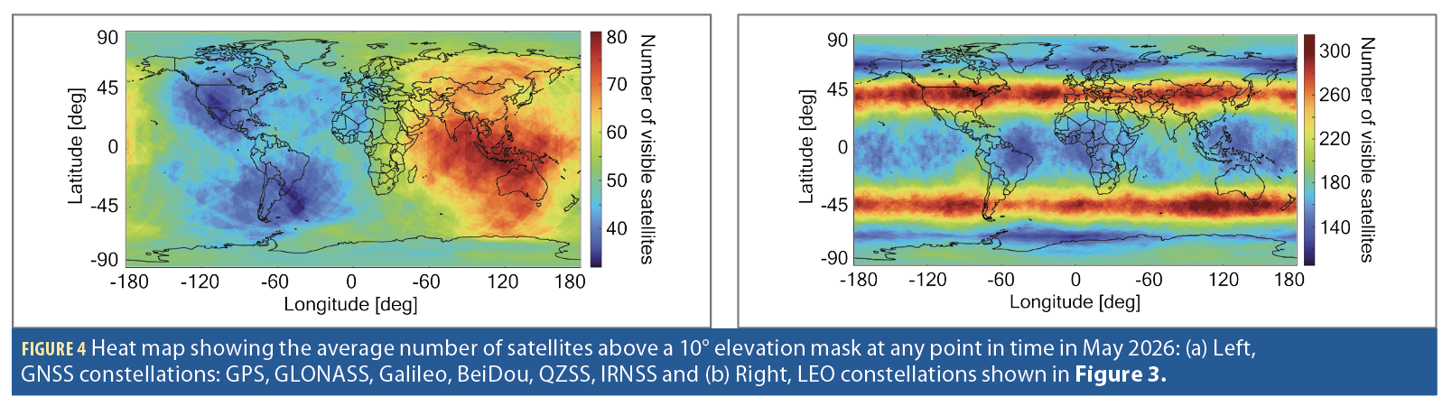
When there are thousands of satellites in LEO, the geometry, availability and signal opportunities begin to change dramatically (Figure 4). You start to get performance that can become comparable to GNSS in certain respects and potentially superior in others. That is what makes mega constellations a game changer for LEO PNT.
Right now, GNSS is the only truly global sensor. LiDAR, vision and radar are powerful, but they are proximity sensors. They can help keep you from colliding with a car or a building, but they do not readily place you directly in a global reference frame. They also do not work equally well in every environment. If you are in an aircraft at 38,000 feet or flying over an ocean with no features, how much can vision help you? If you are operating in a feature poor, denied or degraded environment, what sensor gives you global context?
That is the promise of space based PNT. And LEO, if we learn how to use it properly, can provide a new and powerful layer in that architecture.
The Reason LEO is so Compelling Starts with Physics
LEO satellites are much closer to Earth than GNSS satellites in MEO. Because they are closer, their signals are generally received at higher power. That matters. Higher received power can make a signal more useful and more resilient, particularly in difficult environments.
LEO satellites also move much faster across the sky than GNSS satellites. This faster motion means Doppler becomes highly informative for positioning and navigation. With GPS, Doppler can be useful, but the system is primarily built around pseudorange and carrier phase. With LEO, the fast motion of the satellite itself becomes a major source of navigation information.
Then there is bandwidth. Some LEO communication signals are much wider than traditional civilian GNSS signals. Wider bandwidth can provide better resolution and more precise time estimation. When higher bandwidth is combined with higher received power, fast satellite motion and large numbers of satellites, the PNT opportunity becomes very interesting.
LEO also changes the frequency picture. GNSS is concentrated in the L band. LEO systems operate across a much more diverse set of frequencies. Some are in VHF. Some are in L band. Some are in C band. Many are in Ku and Ka band. This matters because frequency diversity can contribute to resilience. If we limit ourselves to one band, we leave one of LEO’s great advantages on the table.
This is an important point. Many people involved in LEO PNT also worked on GNSS, and there is a natural tendency to duplicate as much of the GNSS model as possible while fixing the most obvious shortcomings. I understand that instinct. But if we are starting fresh, why limit ourselves to one band? Why ignore the signal diversity that LEO offers?
Which band is best? That is hard to say. Some companies favor C band. Others favor L band because it allows users to leverage GNSS antenna infrastructure. Ku and Ka band systems are seeing enormous growth because so many broadband satellites operate there. Whether you like those bands or not, they are going to be a force to be reckoned with.
That is the beauty of LEO. It gives us options. It gives us signal diversity. It gives us Doppler. It gives us stronger signals. It gives us large numbers of satellites. And, used intelligently, it can provide a much needed layer of resilience.
But LEO PNT is not one thing. That is where the taxonomy matters.
The Various Schools of Thought
There are several schools of thought on how LEO should be used for PNT: dedicated, dual purpose, augmented and opportunistic.
The first is dedicated LEO PNT. These are constellations designed specifically to provide PNT from low Earth orbit. Companies such as TrustPoint and Xona are examples. Their systems are built around navigation as the primary mission. This approach has the advantage of intentional design. The signals, payloads, constellation architecture and user equipment can be optimized for PNT. The challenge is scale, adoption, service continuity and the need to build an ecosystem from the ground up.
The second model is dual purpose LEO PNT. In this approach, PNT is paired with another primary service, such as communications. A satellite may be transmitting a communication signal that can also support positioning, navigation or timing. Iridium and Globalstar are examples of constellations that dual-purposed their satellites for PNT. Starlink and Amazon LEO appear to be headed that way. The attraction is obvious: If the satellite infrastructure is already being deployed for communications, perhaps PNT can ride along. The challenge is the signal, business model and operational priorities may not be designed for PNT users first.
The third model is augmented LEO PNT, where LEO is not necessarily a standalone replacement for GNSS. It is part of a multilayer architecture that works with GNSS and other PNT sources. This is where Europe is headed with Celeste, an in orbit demonstrator mission that will feature an 11 satellite constellation. Celeste helps when she can, but she is not positioned as a full standalone global replacement for GNSS. This model may be especially important because the future is unlikely to be one system replacing another. It is more likely to be layered, hybrid and context dependent.
The fourth model is opportunistic LEO PNT. This is the broadest and, in some ways, the most interesting category. Opportunistic PNT can include dedicated, dual purpose or augmented systems, but it can also include signals that were never designed for PNT at all. A communications satellite constellation may not transmit anything intended for navigation, but its signals can still be leveraged for positioning and timing if we know how to use them. Starlink and OneWeb are examples often studied in this context.
A New Way of Thinking About PNT
The shift to LEO also introduces complications GNSS users are not accustomed to thinking about. GPS is a government system. It is offered as a free service. It is mature, open, globally integrated and deeply embedded into receivers, systems, standards, operations and user expectations. GPS is also self contained. A user can wake up a receiver and obtain the information needed to use the constellation. LEO is a different ball game.
Many LEO PNT approaches are commercial or non governmental. That changes the landscape from the user’s point of view. What happens if your subscription lapses? What guarantees do you have that the company providing your PNT service will still exist in five years? What if it is acquired? What if prices rise? What if the service changes? What service level commitments are available? What happens in safety critical applications? How will spectrum licensing work? What does signal access look like? How will standards and interoperability evolve?
These are not side issues. They are central to the future of LEO PNT.
The transition from government provided GNSS to commercial or hybrid LEO services is not only a technical shift. It is an institutional shift. Users who have spent decades relying on open GNSS signals will now have to think about contracts, subscriptions, service guarantees, business continuity, liability, receiver access and long term trust.
Commercial LEO PNT remains a compelling and necessary part of the future PNT landscape. But the industry must be clear-eyed about what changes when PNT becomes part of a commercial service architecture.
Where Will LEO PNT be Used First?
It will first be leveraged where the loss of GNSS hurts the most. Defense, safety-of-life and mission critical applications will be major drivers of adoption, although some sectors, such as aviation, will be difficult to change because of certification, regulation and long equipment cycles.
Drones represent lower hanging fruit. They are critical systems, but they can be adapted more quickly than legacy aviation systems. The market is still developing. Many platforms and operational models are still being built. I expect to see meaningful adoption there, and not just in small drones. Larger unmanned aircraft will also begin leveraging LEO PNT. Some defense applications are already moving in this direction, and that will rapidly grow.
Maritime is another important area. It is heavily regulated, but the need is clear. GNSS interference at sea is already a serious problem, and maritime users need resilient alternatives that can support navigation, timing and situational awareness.
The next wave will likely include autonomous systems and self driving vehicles, although I do not see automotive adoption as immediate. The need will grow as autonomy matures and as platforms require resilient global positioning beyond what proximity sensors can provide.
Eventually, LEO PNT will be integrated into smartphones. There will also be a major push through 6G to make positioning and communications more deeply intertwined. That convergence is coming, and LEO will be part of it.
Regardless of how adoption unfolds, the need is clear. GNSS jamming and spoofing are becoming more sophisticated and more prevalent in Ukraine, the Middle East and other regions. Organized crime and other nefarious actors are capitalizing on GNSS vulnerabilities in the civilian world. Unintentional interference is also a growing problem. Lives are being lost. Damage is being done. And the situation will only get worse if we do not act.
Autonomous systems first forced the PNT community to confront the limitations of GNSS alone. Jamming, spoofing and interference then exposed vulnerabilities that can no longer be treated as rare exceptions. We need complementary systems. We need backups. We need resilience. We need architectures that do not fail catastrophically when GNSS is denied or manipulated.
Why LEO, Why Now
LEO has been born again at the right moment. The surge in satellites has made LEO an attractive option for space based PNT. The signals are stronger. The satellites move faster. The bandwidths can be much wider. The frequencies are more diverse. The number of potential signals is growing dramatically. And unlike terrestrial alternatives, LEO has the potential to provide broad, space based coverage that can complement GNSS at scale.
The question is simple: We have mega constellations in LEO. Why not use them?
LEO PNT is an emerging area, and it is changing constantly. Inside LEO will help readers understand what is real, what is hype, what is technically possible and what still needs to be solved. In future columns, I will dive deeper into LEO fundamentals, deployment models, the current state of LEO, user demand, operational adoption, signal design, standards, interoperability and the future of resilient PNT.
GNSS transformed the world. But the world GNSS helped create now demands more than GNSS alone can provide.
That is why LEO matters. And that is why we need to understand it now.
References
(1) Z. Kassas, J. Morales, and J. Khalife, “New-age satellite-based navigation—STAN: simultaneous tracking and navigation with LEO satellite signals,” Inside GNSS Magazine, Vol. 14, Issue 4, Aug. 2019, pp. 56-65.
(2) J. Khalife and Z. Kassas, “Receiver design for Doppler positioning with LEO satellites,” Proceedings of IEEE International Conference on Acoustics, Speech, and Signal Processing, 2019, pp. 5506-5510.
(3) J. Morales, J. Khalife, and Z. Kassas, “Simultaneous tracking of Orbcomm LEO satellites and inertial navigation system aiding using Doppler measurements,” Proceedings of IEEE Vehicular Technology Conference, 2019, pp. 1-6.
(4) J. Morales, J. Khalife, A. Abdallah, C. Ardito, and Z. Kassas, “Inertial navigation system aiding with Orbcomm LEO satellite Doppler measurements,” Proceedings of ION GNSS+ Conference, 2018, pp. 2718-2725.
ZAHER (ZAK) M. KASSAS is a global leader in resilient and alternative PNT. He is the TRC Endowed Chair in Intelligent Transportation Systems and a Professor at The Ohio State University. He is the Director of the U.S. Department of Transportation Center for Automated Vehicle Research with Multimodal AssurEd Navigation (CARMEN+) and Director of the Autonomous Systems Perception, Intelligence & Navigation (ASPIN) Lab. A Fellow of IEEE and ION, he has authored over 200 publications and holds multiple patents. He was awarded by President Biden the Presidential Early Career Award for Scientists and Engineers (PECASE), the highest honor bestowed by the U.S. government on outstanding scientists and engineers; the IEEE AESS Richard Kershner Award for pioneering contributions to the theory and practice of PNT with terrestrial and non-terrestrial signals of opportunity; and more than 60 scientific and governmental awards. He was ranked as the top scholar globally in the field of Navigation. His research has attracted more than $28 million in competitive grants; has been featured in dozens of international media outlets; and has shaped government programs, policies and investments.