Accurate real-time positioning is a necessary condition for many land transportation applications. But positioning alone cannot ensure successful and safer navigation, let alone higher-order driver assistance and awareness applications. The most common accessory to positioning is a map database — of more or less sophisticated design with greater or lesser data content and granularity.
Accurate real-time positioning is a necessary condition for many land transportation applications. But positioning alone cannot ensure successful and safer navigation, let alone higher-order driver assistance and awareness applications. The most common accessory to positioning is a map database — of more or less sophisticated design with greater or lesser data content and granularity.
Another resource and tool for navigation, route guidance, and advanced assistive systems is the application of geometrical principles to the positioning and mapbase data to anticipate or project upcoming conditions and events along a route.
This article introduces the map database as a sensor in driver assistance and awareness applications, which begin with a map-matched position and then look ahead from that position to determine the most likely driving path (MLP). From this calculation, we can support assistance and awareness applications such as curve speed warning, predictive adaptive front lighting systems, adaptive cruise control, and forward collision warning.
We will explore the role of MLP in these applications as well as its use in modifying route guidance instructions and map-matched positions. Finally, this article will also take up the question of map requirements and the navigation system interface needed for such applications.
Path Prediction
Adaptive cruise control (ACC) and forward collision warning (FCW) require systems that can determine the primary target in the host vehicle lane and then accurately estimate the geometry of the road between the host and the target vehicle. Curve speed warning (CSW) also requires knowing the geometry of the intended driving path to warn the driver of going too fast for the upcoming curve. Predictive adaptive front lighting can use the predicted road geometry to swivel the headlamps in the road curvature direction.
. . .
Driver Assistance, Awareness
Visteon has used GPS and map databases as sensors. In a road departure crash warning (RDCW) field operational test funded by the U.S. Department of Transportation (DoT) and completed last year, Visteon developed a CSW functionality using a commercial navigation system and map database. The CSW system warns the driver when the vehicle is traveling too fast for an upcoming curve by processing the map database geometric and attribute information.
. . .
Land Vehicle Navigation
Route guidance is an essential feature in current land navigation systems. In this navigation feature, a driver feeds the navigation system with the desired trip destination. The route guidance algorithm calculates the route for the driver to follow. The driver may make mistakes in following the intended (calculated) route, and the route guidance system will have to adjust its instruction to correct this mistake.
. . .
Map Database as a Sensor
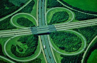
Current commercial map databases are designed for navigation purposes. The accuracy of these maps is sufficient for navigation in a large variety of road scenarios. However, they sometime fail in such situations as service drive/highway, highway/exit ramp, fork, complex overpasses, and mountain area/single road. All of these scenarios could lead to placing the vehicle on the wrong road or off the road.
. . .
Conclusion
Map database can provide detailed information of the road segment at the vehicle position and the road segments ahead of the vehicle. This information when processed can be used for advanced driver assistance and awareness applications Moreover, these systems should incorporate a map corrective/updating capability due to the changing nature of the roads and associated driving restrictions.
Map database errors can arise in such road scenarios as merging, road connections (overpasses), divided/undivided roads, and mountains areas In order to optimally use the map database, such error sources should be defined and modeled. Furthermore, inclusion of additional information such as height or elevation could extend the usage of the map for other automotive applications. From a commercialization perspective, it is recommended to standardize the navigation system interface.
For the complete story, including figures, graphs, and images, please download the PDF of the article, above.


