
Collins Aerospace unveiled the second iteration of its Mounted Assured Positioning, Navigation and Timing System (MAPS) for warfighters at the Association of the United States Army (AUSA) 2020 conference in Washington, D.C., October 11–13. The company had recently received a contract award for MAPS to be the alternative PNT (A-PNT) solution on all Army ground vehicles, based on performance of its Gen I technology, with the promise of Gen II to be forthcoming shortly. Now it’s here.
MAPS maintains the integrity of positioning and timing in GPS-contested environments and keeps up with the pace of current and future enemy threats and technologies. MAPS Gen II reduces vehicle system changes by using a smart, two Line-Replaceable-Unit (LRU) system that cleanly replaces the existing navigation system in the vehicle for easier upgrade and sustainability.
The MAPS Gen II system
Comprised of Collins Aerospace’s NavHub-100 navigation system and Multi-Sensor Antenna System (MSAS-100), MAPS Gen II raises protection levels against evolving GPS threats to support multi-domain operations and mitigate the evolving electronic threats that warfighters face today. New benefits of the system include Military Code (M-Code) capability and improved levels of reliability through patented Modernized Signal Tracking (MST) that enhances GPS integrity.

NavHub-100 navigation system
NavHub-100 is generates and distributes Assured Position, Navigation and Timing (APNT) information to all systems onboard the platform through one device. It provides a high-assurance, accurate navigation solution across GPS threat environments with the NavFusion of multiple sensors.
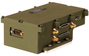
- Implements modernized signal tracking to ensure GPS integrity
- Supports Defense Advanced GPS Receiver (DAGR) standard interface
- Includes M-Code Security Certified Card
- Size/volume : 6.5 in. L x 4.125 W in. x 2.375 in. H
- Weight <2.1 lbs
Anti-jamming performance
• Better than 41 dB J/S while tracking (state 5)
• Better than 54 dB J/S (state 3)
System characteristics
• GPS/INS navigator
• Advanced integrity algorithms (OSIRIS and SENTRI) to provide
an assured solution
• Ground-aided navigation for GPS-denied conditions
(less than 2% distance traveled)
• External wheel sensor input for velocity aiding during GPS outage
• Precision time frequency estimation for computing
sub-nanosecond time accuracy
• Internal OCXO time reference for maintaining time accuracy
• Disciplined 10 MHz output clock for precision time applications
• Designed to integrate with high capability anti-jam systems
such as MSAS-100
• Four DAGR emulators compliant with IS-GPS-153 to allow for
easy integration with existing fielded systems
• External barometric pressure input for altitude aiding over RS-232
• Web interface to provide easy access to configuration using
any laptop
• ASPN-capable expansion Ethernet port and scalable architecture to
support future sensors such as AltNav, GNSS and visual odometry
• Ethernet maintenance port for reprogramming and test
data collection
Multi-Sensor Antenna System (MSAS-100)
Additional protection comes with the ground-based MSAS-100 anti-jam antenna, providing superior immunity in the most severe GPS-challenged environments.
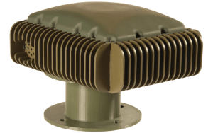
• Offers superior digital beamforming
• Supports up to 24 simultaneous beams for jamming immunity
• Delivers exceptional anti-jamming performance
• Incorporates seven-element CRPA
• Provides simultaneous L1/L2 protection
• Supports Y-Code and M-Code anti-jamming
• Supports SFAP beamforming
• Sized at 288 cubic inches
• Includes AltNav single patch antenna, barometer and orientation sensor to support Assured PNT applications
• Can operate as a digital nuller
• MST capable-advanced software algorithm providing GPS integrity against all spoofing types
• Weight: <11 lbs.
• Size/volume: 9” D x 8” W x 4” H/288 ci
TruNET Communications
MAPS II is interoperable with the Collins Aerospace PRC-162 manpack radio to ensure mission success in the Joint All Domain Command and Control (JADC2) battlespace. TruNetAN/PRC-162(V)1 is a two-channel networked communications ground radio offering multiple waveforms, narrowband and wideband, high-speed mobile ad hoc networked communications, point-to-point data, voice, next-generation SATCOM and the latest in-theater IP-based waveform communications.


