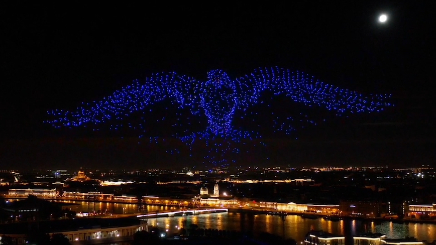
u-blox announced that it supplied the high-accuracy technology that made it possible to fly the world’s largest swarm of drones. The record-breaking simultaneous flight of 2198 miniature UAVs was launched into the night sky over Saint Petersburg, Russia, on September 3. The ten-minute long drone show included a flying dove with a wingspan of 600 meters, visible from three kilometers away.
Geoscan, which built and programmed the drones and ran the display, chose u-blox positioning technology for its ability to access positioning data from both GLONASS and GPS signals. The Geoscan Salute drones, which are ten centimeters across, were designed exclusively for use in group flights and drone shows.
The drones use u-blox NEO-M8P high precision GNSS modules to provide the positioning data necessary to ensure that they can be placed in the sky with a high degree of accuracy. This makes them less likely to collide with each other and enables them to be moved more quickly and efficiently. This produces a more fluid drone show, improved positional accuracy of each drone, a better overall display and contiguous figure forms. Salute drones can also return to their base stations automatically at the end of a show.
The NEO-M8P high precision GNSS module used in the Salute drones implements a real-time kinematic (RTK) approach. The drones calculate their relative positions to within millimeters, and their absolute positions to within one centimeter of the intended position, according to the companies.
Geoscan has been producing drone displays for the past two years, starting with just 40 drones flying at once. Semen Lapko, Head of Drone Show Project, Geoscan, said: “The u-blox modules in our Geoscan Salute drones have improved our drones’ positioning accuracies to about one centimeter, and have helped reduce pre-launch preparation time. Drones now move more quickly and accurately, while also operating more efficiently.”
u-blox is a technology provider in positioning and wireless communication in automotive, industrial, and consumer markets.
Geoscan Group is a Russian manufacturer of unmanned aerial vehicles (UAV) and developer of photogrammetric data processing and three-dimensional data visualization software. Geoscan group has offices in Moscow and Saint Petersburg.


