
Enhancing GNSS resilience through an AI-based multi-layered monitoring system.
AMIR TABATABAEI, YASAMIN KESHMIRI ESFANDABADI, IGASPIN GMBH
Global Navigation Satellite Systems (GNSS) have become crucial for more than just accurate location and navigation; they are also essential for delivering highly reliable timing. Recent reviews of GNSS use cases show how widespread this technology has become across civilian, commercial and military domains, underscoring the urgent need to make these systems more resilient.
But as our dependence on GNSS grows, so do the risks associated with any disruptions. Radio Frequency Interference (RFI), whether deliberate or accidental, remains a constant threat to GNSS performance and reliability. Back in 2017, disruptions to GNSS in Europe were estimated to cause economic losses totaling €1 billion, according to the European GNSS Agency (GSA) [1]. In the U.S., a five-day GPS outage could potentially result in a staggering $45 billion in damages, based on figures from the National Institute of Standards and Technology (NIST) [2]. Similarly, the Federal Aviation Administration (FAA) estimates that GPS interference costs the aviation sector about $1.3 billion annually [3].
GNSS is vulnerable to a range of interference types, most often grouped into five main categories: multipath, wide-band noise, jamming, meaconing and spoofing. These issues can either disrupt the service entirely, making GNSS unusable, or trick the receiver into showing false or misleading data. How these threats are classified can vary by framework. Some systems group them by their effects such as denial (blocking service) versus deception (misleading data) while others sort them based on their source: natural, accidental, intentional, or according to how they interfere with GNSS signals.
Approaches to Safeguard GNSS from RFI Threats
As GNSS becomes more critical to essential infrastructure, it is vital to establish a well-structured and coordinated plan to protect it from RFI. This approach rests on three main pillars: Protection, Augmentation and Toughening.
Protection: Guarding the Spectrum and Enforcing Rules
The Protection strategy is all about defending GNSS signal bands and developing a nationwide system for fast detection, regulation and enforcement. This includes making sure nearby frequency users stick to strict power limits so their transmissions don’t unintentionally interfere with GNSS operations.
Setting up real-time detection systems for RFI allows for the rapid identification and pinpointing of jamming or spoofing events, which is crucial for timely responses. But protection is not only about tech solutions. It also means updating outdated laws like the U.S. Communications Act of 1934 and applying strong anti-interference regulations at every level of government. Success in this area also hinges on having enforcement teams that are well-trained, properly equipped, and ready to take legal action against offenders.
Augmentation: Boosting Confidence and Precision Using External Inputs
Augmentation improves the robustness of GNSS by adding extra layers of correction and verification from outside sources. Traditional augmentation systems like Satellite-Based Augmentation System (SBAS), including the Wide Area Augmentation System (WAAS) and European Geostationary Navigation Overlay Service (EGNOS), boost location accuracy and reliability by sending correction signals from networks of ground stations.
More advanced augmentation also includes tools that verify the authenticity of signals. For instance, Galileo’s Open Service Navigation Message Authentication (OSNMA) uses cryptographic methods to ensure satellite messages are genuine, helping detect spoofing attempts. Likewise, Galileo Public Regulated Service (PRS) offers secure, encrypted signals restricted to authorized users, serving as a protected fallback when standard GNSS services are compromised.
New initiatives are also pushing for land-based augmentation solutions like wide-area fiber-optic time transfers, positioning, navigation and timing (PNT) signals from Low Earth Orbit (LEO) satellites, and terrestrial radio beacons. These approaches aim to lessen our dependence on satellite-only GNSS systems. Embracing a broad mix of these complementary augmentation technologies is increasingly seen as essential for ensuring national PNT resilience.
Toughening: Building Robustness Directly into GNSS Receivers
Toughening means upgrading GNSS receivers themselves so they can continue functioning despite interference. This involves incorporating technologies like Controlled Reception Pattern Antennas (CRPA), beamforming, adaptive filtering and Automatic Gain Control (AGC). These features help the receiver stay locked onto valid signals while blocking or minimizing unwanted interference, even when under attack from jamming or spoofing.
Another key strategy is using multi-sensor fusion. By combining GNSS data with inputs from Inertial Navigation Systems (INS), receivers become more resilient and can maintain accurate positioning even in compromised environments. For critical infrastructure, it is now standard practice to use more than one independent PNT source to ensure reliable operation during prolonged GNSS outages.
Although augmentation methods like OSNMA, PRS and LEO-based signals greatly improve the security and reliability of GNSS, they are not entirely resistant to advanced interference tactics. These tools are essential for spotting irregularities and verifying signal authenticity, but they can still be compromised by targeted attacks. For instance, LEO-based navigation signals, despite offering stronger signal power and lower latency, can still fall prey to jamming or spoofing.
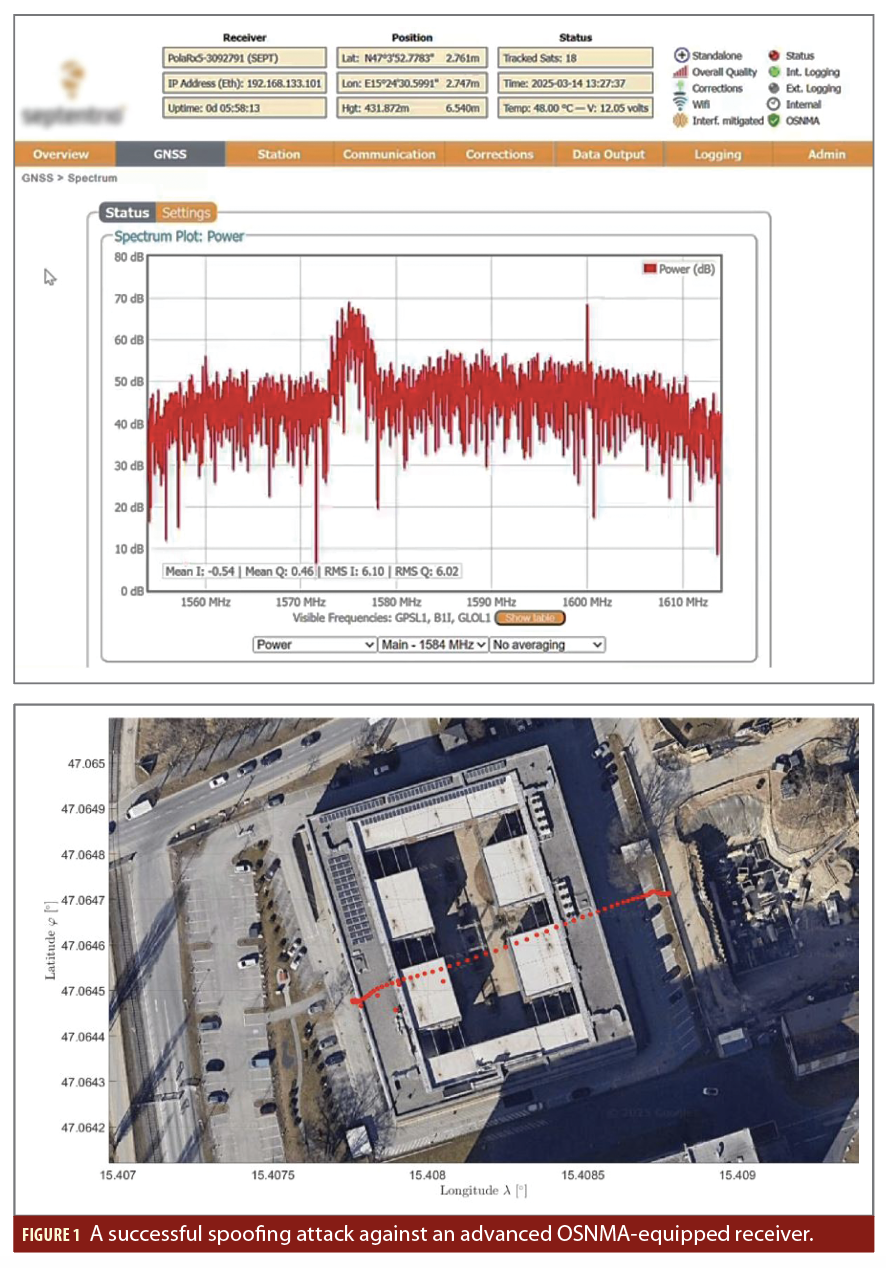
In a recent lab experiment, IGASPIN’s team managed to spoof a modern GNSS receiver equipped with OSNMA using their sophisticated spoofing tool, LOKI (Figure 1). This test showed that even systems protected with cryptographic features can be tricked if attackers exploit timing flaws or weaknesses in signal structure (In this case, both the spoofer and the receiver were operating in the L1/E1 frequency band. IGASPIN plans to investigate OSNMA spoofing more using a wider array of receivers).
Although strengthening GNSS receivers through methods like CRPA antennas, beamforming, and advanced filtering greatly improves their resistance to jamming and spoofing, these techniques come with significant downsides. They typically require more complex and sophisticated hardware, which can make the devices bulkier, more power-intensive, and costlier. As a result, these enhancements are well-suited for specialized sectors like military, aviation or essential infrastructure, but they are less practical for everyday consumer devices like smartphones, wearables or budget IoT products.
Because of this, IGASPIN emphasizes that protection, especially in the form of detection, classification and localization should be the top priority in any GNSS defense strategy. This approach offers the most universally applicable safeguard, capable of supporting both critical systems and consumer-level devices. However, true protection goes beyond just deploying new technologies. It also requires the rollout of suitable monitoring tools and establishing a strong legal and regulatory framework.
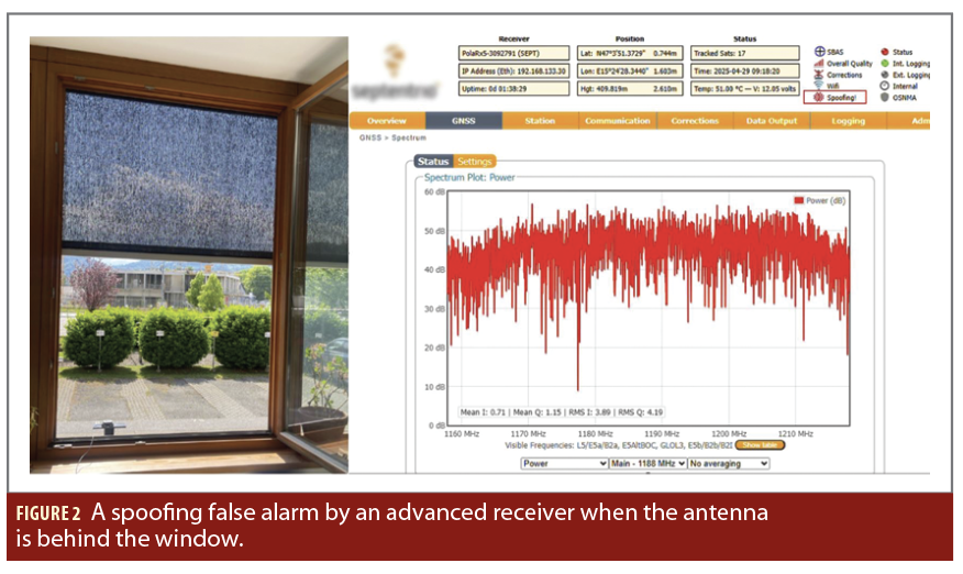
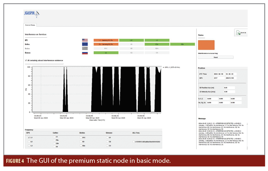
Selecting the right monitoring equipment is crucial. Poorly chosen or incorrectly installed sensors can trigger excessive false alarms, reducing confidence in the detection network. In one of IGASPIN’s tests, for instance, a receiver falsely flagged a spoofing attempt simply because the antenna had been placed near a window. The resulting signal distortion, though harmless, led to misclassification due to multipath effects, highlighting the importance of installation quality in achieving reliable performance (Figure 2).
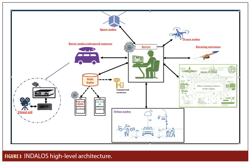
INDALOS Monitoring Devices for GNSS Protection
INDALOS is an advanced, layered system for monitoring GNSS interference that’s built to safeguard the reliability of PNT services (Figure 3). It is engineered to function across a wide range of settings from isolated rural areas to busy cities and even space. The system combines a flexible mix of different types of sensing nodes with a centralized artificial intelligence (AI)-powered platform, enabling full-spectrum detection, classification and pinpointing of GNSS-related threats.
At the heart of the INDALOS system is a distributed network of sensors, with each type of node customized for specific use cases:
Static nodes: Static nodes are stationary, ground-based units designed to deliver ongoing, long-term monitoring at essential infrastructure sites.
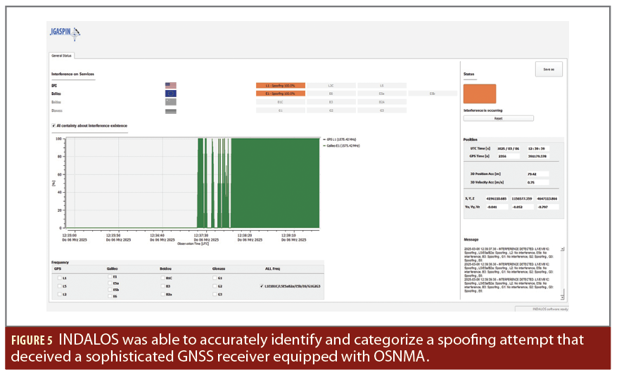
As an example, the INDALOS premium static node was able to accurately identify and categorize a spoofing attempt that deceived a sophisticated GNSS receiver equipped with OSNMA (Figure 5). At first, the spoofing signal’s correlation peak was nearly aligned with the genuine signal and slightly weaker, leading the AI system to flag the event as ambiguous, raising alerts for both spoofing and multipath because of their similar signal traits. As the spoofing progressed and the correlation peak grew stronger and more pronounced, INDALOS successfully reclassified the event as a spoofing attack, showcasing its ability to adapt and reliably detect complex interference scenarios.
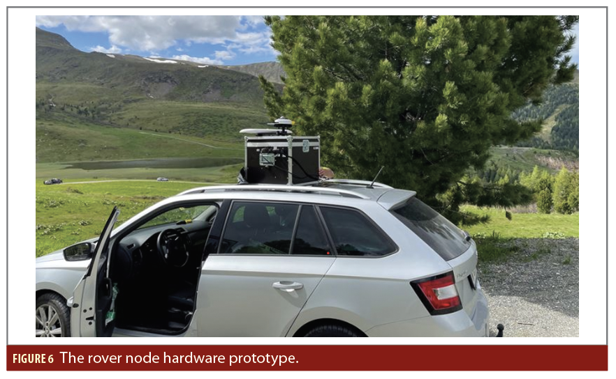
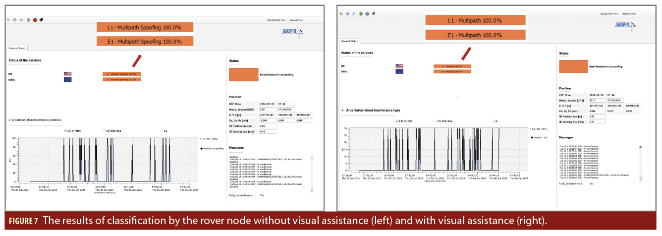
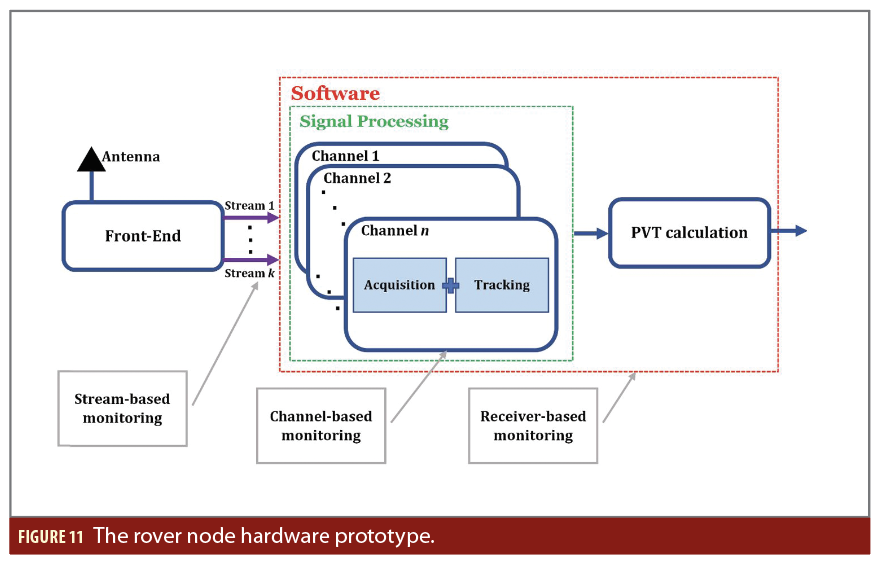
Rover nodes: These are mobile sensing units mounted on vehicles or carried by personnel, specifically designed to monitor GNSS interference in fast-changing or high-risk environments. They work alongside static nodes by gathering in-depth data in areas where interference is suspected. Each rover is equipped with an antenna, signal front-end, and a compact computer, as well as a visual support module that captures and evaluates images (Figure 6). This visual data aids the onboard decision-making system in more accurately differentiating between spoofing and multipath effects, which often display similar signal patterns (Figure 7).
Urban nodes: These compact devices are built to handle the complexities of city environments, where signal reflections (multipath) and radio frequency (RF) congestion are common.
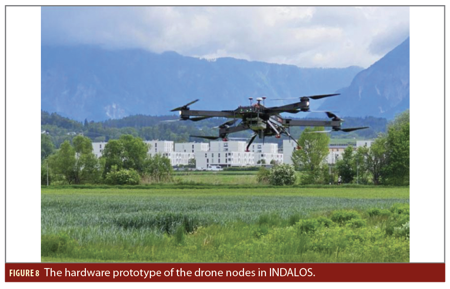
Drone nodes: Lightweight sensors mounted on UAVs, used for quick evaluations, scanning large areas and offering adaptable coverage from the air (Figure 8).
Space nodes: Satellite-mounted systems that monitor GNSS from orbit, giving a global perspective on interference and adding valuable data to ground-based monitoring.
Existing GNSS receivers: INDALOS can connect with older or third-party GNSS receivers, making it easy to incorporate existing infrastructure into its monitoring system.
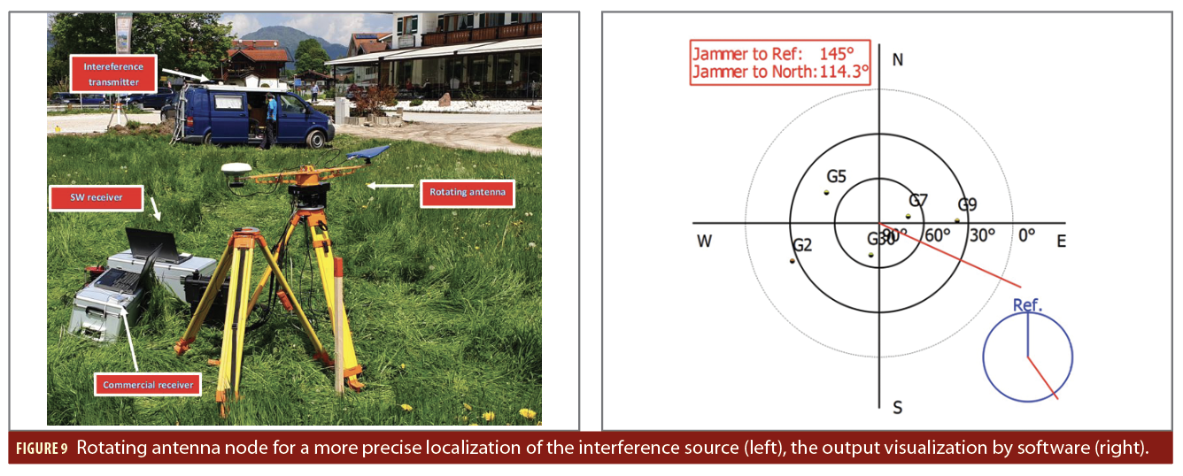
Rotating antenna nodes: These specialized sensors collect direction of arrival (DoA) data, which enhances spatial detail and helps pinpoint the exact sources of interference (Figure 9).
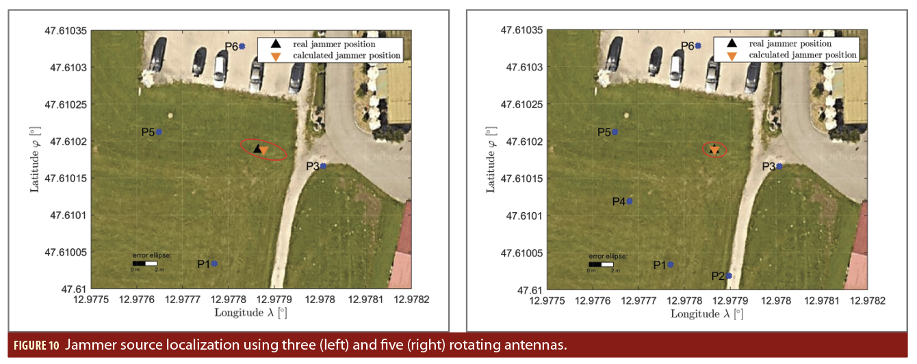
During a test conducted as part of a development project, the rotating antenna was used to estimate a jammer’s location. When three antennas were used, the standard deviation of the position estimate was 3.62 meters. Using five antennas improved the accuracy, reducing the standard deviation to 2.03 meters. These results were derived using Helmert transformation techniques (Figure 10).
All node types are synchronized and configured to feed real-time signal metrics and event data into a centralized processing system.
The INDALOS Server—Intelligent AI-Powered Control Hub
At the core of the INDALOS system is its server, a sophisticated software engine tasked with collecting, processing, analyzing and visualizing data. It gathers raw input from all sensor nodes and converts it into actionable insights.
Key features include:
Real-Time Detection and Classification: Uses the received information to identify threats like jamming, spoofing, chirps, wide-band noise, and multipath effects in a region.
Localization: Uses both Received Signal Strength (RSS) triangulation and DOA data from rotating antennas for accurate identification of interference sources.
AI-Based Decision Support: Applies AI to cut down on false positives, adapt to different environments, and deliver meaningful alerts.
Visualization and Reporting: Includes a user-friendly GUI showing system status, node health, threat locations, and in-depth interference analytics.
The INDALOS server supports both local and remote deployment, runs on TCP/IP and SSH protocols, and scales easily for use at regional or national levels.
Monitoring Algorithms in Premium Static Nodes
Conventional GNSS interference detection techniques like monitoring signal power or using Power Spectral Density (PSD)analysis can provide useful data, but they often fall short in terms of accuracy, scalability and real-time use when deployed in isolation.
To address these limitations, INDALOS employs a comprehensive, AI-supported decision framework built on more than 14 advanced detection algorithms. These algorithms are organized based on the architecture of GNSS receivers and fall into three main categories, allowing for multi-layered analysis that boosts detection accuracy and reduces false alarms.
Stream-Based Algorithms
These algorithms constantly observe the raw GNSS signal streams, where each stream corresponds to a particular frequency and bandwidth. They are designed to catch sudden anomalies or disruptions in the incoming RF or IF signals. This approach is especially effective for detecting broad-spectrum jamming, bursts of interference, or unusual power shifts. Continuous signal monitoring forms the frontline defense against fast, aggressive types of interference.
Receiver-Based Algorithms
These methods evaluate the overall health and performance of the GNSS receiver. In the INDALOS system, this includes position, velocity time (PVT) monitoring, which looks for unexpected changes or irregularities in calculated position or time. These indicators may point to more subtle or deceptive interference, such as spoofing. This type of analysis is key to identifying slow, stealthy attacks that may not immediately break signal tracking but still mislead the user.
Channel-Based Algorithms
Each GNSS channel in a receiver is dedicated to tracking an individual satellite signal and is sensitive to interference. Channel-based algorithms assess these individual signal paths, focusing on internal performance metrics like tracking loop stability, use of multi-correlators, and signal strength.
AI-Enhanced Decision Making at Premium Static Nodes
Each premium static/rover node in the INDALOS network includes an embedded AI system that performs live signal classification. Instead of relying on just one detection method, the AI smartly combines insights from stream-based, receiver-based and channel-based
algorithms to form a comprehensive understanding of the surrounding signal environment.
This AI engine uses unsupervised learning, meaning it can adjust to unfamiliar or changing interference types without needing pre-labeled training data, an essential advantage in unpredictable real-world conditions.
For this purpose, INDALOS uses a certainty-based fusion model. Each algorithm assigns a confidence score. These scores are then merged and weighted by the AI, helping it make well-informed, explainable decisions about whether interference is present and what kind it is (e.g., jamming, spoofing or multipath). This smart, multi-layered strategy significantly improves detection accuracy while keeping false alarms to a minimum, even in noisy or complex environments.
Conclusion
While augmentation and toughening strategies have critical roles in providing reliable navigation using GNSS, IGASPIN advocates that protection through intelligent monitoring and enforceable regulation must remain the foundation of any national or regional GNSS defence strategy.
Unlike conventional monitoring systems that often depend on single-layered or hardware-specific techniques, IGASPIN’s INDALOS offers a comprehensive, multi-layer and scalable architecture, integrating various types of sensors, all feeding real-time data into a centralized AI-based server for intelligent interference detection, characterization and localization.
Leveraging a combination of multiple advanced detection algorithms, fused using AI decision logic, INDALOS premium nodes deliver high sensitivity while maintaining low false alarm rates. Tests have demonstrated its ability to detect sophisticated spoofing attacks, even those that could mislead very advanced receivers.
References
(1) European GNSS Agency (2018). The Economic Benefits of Galileo: Impact on the European Economy. Available at: https://www.gsa.europa.eu/sites/default/files/gnss-in-eu-economy-study.pdf
(2) National Institute of Standards and Technology (2012). Economic Consequences of Disruptions in Global Positioning System (GPS) Services. Available at: https://www.nist.gov/system/files/documents/el/isd/GPS_econ_stdy.pdf
(3) Federal Aviation Administration (2017). Economic Study on the Value of GPS and Augmentation Systems for Aviation. Available at: https://www.faa.gov/about/plans_reports/media/Value_of_GPS_and_Augmentation_Systems_for_Aviation_2017.pdf
Authors
Dr. Amir Tabatabaei is the Chief Technology Officer at IGASPIN GmbH in Austria, specializing in GNSS. He has significantly contributed to the field through his research on GNSS software receivers, interference generation/mitigation, and artificial intelligence applications. Notably, he developed “Tuti,” an advanced GNSS-based repeater for seamless indoor/outdoor positioning. Dr. Tabatabaei has authored two books, holds two patents, and has published numerous papers on GNSS signal processing and receiver design. He has also managed several projects, including collaborations with the European Space Agency (ESA).
Yasamin Keshmiri Esfandabadi has a B.S. in electronics engineering and a M.S. in mechatronics engineering. She received a Ph.D. in electronic engineering from the University of Bologna, Italy. She is currently an electronic engineer at IGASPIN GmbH in Graz, Austria. Her research focuses on signal processing for positioning, navigation and timing (PNT) monitoring.


