In a recently published patent, electric car maker Tesla outlines plans to develop a software that aims to use other vehicles on the road as Earth-based GPS satellites. Such a system would allow Tesla to improve its fleet’s positioning accuracy, even in areas where GPS signals are usually compromised, according to the company.
The car maker states in its patent’s background that while GPS signals from space-based satellites are invaluable, factors such as satellite geometry, signal blockage, ionospheric perturbation, and atmospheric conditions, among others, can affect the accuracy of GPS receivers. Because of this there is a need to develop a system that can greatly improve location accuracy, mainly as it would be utilized extensively by full self-driving vehicles.
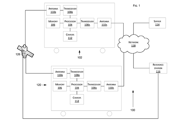
The patent, titled “Technologies for vehicle positioning,” describes a software that allows vehicles to send signals and positioning data to each other. This solution allows the cars to function much like Earth-based GPS satellites, feeding positioning information to other vehicles on the road. Tesla notes in its patent that the software is flexible, being capable of operating via at least one network protocol, such as Ethernet, a Transmission Control Protocol (TCP)/lnternet Protocol (IP), or others.
This latest patent application from Tesla was filed in 2017 and made public last December. In the application, the car maker describes a problem with the accuracy of GPS positioning:
“For example, a smartphone with a positioning receiver may be able to determine its position to within five meters of the smartphone. The accuracy of the position determination may worsen when the receiver is in proximity of buildings, bridges, trees, or other structures. Although this may be sufficient for some positioning applications, greater accuracy is desirable for other applications, including autonomous driving. Accordingly, there is a desire to provide greater positioning accuracy despite the factors that affect the signals from the navigation satellites.”
The document offers a variety of solutions that involve cameras detecting matching locations and using other vehicles in its fleet as a “cooperative reference station” to share raw GNSS data and make positioning corrections.
Without necessarily sharing data between vehicles, Tesla also found a way to correct GPS data using other sensors, the company stated. By matching camera data with vision maps, you can detect the exact location of a vehicle, and these types of solutions would enable Tesla vehicles to have more accurate positioning data even where the GPS signal is not as strong as they would like.
This more accurate positioning system would be especially useful for autonomous driving applications and Tesla clearly intended it to be used by its Autopilot system since all the inventors listed on the patent applications were part of the Autopilot team at the time.


