GLONASS
Program updates revealed steady progress by Russia, with a delegation headed by Yury Nosenko (deputy director of the Russian Space Agency or Roscosmos), which expects to have 24 GLONASS satellites or space vehicles (SVs) on orbit by the end of 2009.
GLONASS
Program updates revealed steady progress by Russia, with a delegation headed by Yury Nosenko (deputy director of the Russian Space Agency or Roscosmos), which expects to have 24 GLONASS satellites or space vehicles (SVs) on orbit by the end of 2009.
Sergey Revnivykh, director of the Satellite Navigation Department in the Roscosmos Mission Control Center, noted that flight test of the first GLONASS-K satellite toward the end of 2010 will allow Russia to evaluate new CDMA signals that it plans to broadcast at L1 and possibly L3 frequencies.
GLONASS will continue transmitting its existing FDMA signals for the “unlimited future” to provide backward compatibility, Revnivykh added.
Compass
China announced plans to launch 3 to 4 Compass (Beidou 2) spacecraft in 2009 and 11 over the next two years.
Jun Lu, representing the China Satellite Navigation Project Center, said that results from 18 months of observations of the first Compass middle earth orbiting (MEO) satellite launch in April 2007 indicated a precise orbit determination of better than 5 meters as well as the ability to predict future orbits of better than 10 meters over a 24-hour period.
The four rubidium atomic frequency standards on board the MEO-1 spacecraft are providing a synchronization with Compass system time of about two nanoseconds, she said.
GPS
Presentations by U.S. representatives focused on recent publication of new performance standards, progress in U.S. space- and ground-based augmentation systems, and GPS interference detection and mitigation.
They also described GPS modernization plans scheduled to bring fully operational capability (FOC) with 24 GPS SVs broadcasting the second civil signal (L2C) by 2016, L5 by 2018, and the new L1 civil signal by 2021.
U.S. presenters included Mike Shaw, director of the National Coordination Office for Space-based PNT, Leo Eldredge, GNSS program director at the Federal Aviation Administration, Col. David Goldstein, chief engineer for the GPS Wing at Los Angeles Air Force Base, and John Merrill, with the Office of Applied Technology, Geospatial Management Office, in the Department of Homeland Security. Lt. Col. Patrick Harrington, from the Office of the Under Secretary of the Air Force Directorate of Space Acquisition, headed the U.S. delegation.
Galileo
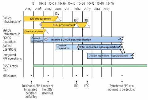
Paul Verhoef, head of the Galileo unit for the European Commission Directorate-General for Transport and Energy, said that the EU expects to have contracts for building the Galileo FOC system in place by next summer.
He noted that the target date for completion is 2013 had been given to prospective vendors in the Galileo invitations to tender (ITTs). “We’ll see if and how they will make it.”
The European GNSS Supervisory Agency (GSA), which had been charged with overseeing development and operation of Galileo under the abandoned public-private partnership, will be given a different name next year to reflect its altered responsibilities under the public procurement now led by the EC and the European Space Agency.
Verhoef added that about 30 GSA staff members will soon be transferred to the EC’s Galileo unit.
Meanwhile, despite pointed industry encouragement, Verhoef did not say when a final interface control document (ICD) would be available. Manufacturers need the commercial terms and technical specifications in order to build and sell Galileo-capable equipment with confidence.
GAGAN
The Indian government has approved the follow-on plan for its satellite-based augmentation system — the GPS Aided, Geo Augmented Navigation (GAGAN, which stands for “space” in Sanskrit).
India plans to launch the first payload on its GSAT-4 satellite next April or May and a second GAGAN payload on GSAT-8 during the last quarter of 2009, according to Suresh Kibe, satellite navigation program manager at the Indian Space Research Organization (ISRO). A third GAGAN GEO is scheduled for launch on GSAT-9 or -10 in 2010.
Kibe says development continues for the Indian Regional Navigation Satellite System (IRNSS), with seven to nine satellites in both geosynchronous and non-geosynchronous orbits. It will include an open standard positioning service (1Mhz, biphase skip keying signal) and a restricted service — BOC (5,2) signal — at 1176.45 MHz (L-band) and 2492.08 MHz (S-band).
India is studying the signal structures of GPS L2C, L5, and L1C as the basis for the IRNSS signal design.
QZSS
The Japan Aerospace Exploration Agency (JAXA) will launch the first satellite in its Quasi-Zenith Satellite System (QZSS) in the summer of 2010, followed by a year of in-orbit validation.
In addition to several open signals closely aligned with GPS, QZSS will include two additional signals — an L1-SAIF (submeter-class augmentation with integrity function) and an experimental signal (LEX) at 1278.75 MHz. These may be implemented with fees charged by a private operator, according to Koji Terada, QZSS program manager for JAXA.


