After reports of an apparent mass and blatant GPS spoofing attack involving more than 20 vessels in the Black Sea last month, navigation experts and maritime executives are scratching their heads and the president of the Resilient Navigation and Timing (RNT) Foundation is hoping this latest incident will help spur more action toward building an eLoran complement and backup for GPS.
After reports of an apparent mass and blatant GPS spoofing attack involving more than 20 vessels in the Black Sea last month, navigation experts and maritime executives are scratching their heads and the president of the Resilient Navigation and Timing (RNT) Foundation is hoping this latest incident will help spur more action toward building an eLoran complement and backup for GPS.
The event in the Black Sea first came to public notice via a relatively innocuous safety alert from the U.S. Maritime Administration:
A maritime incident has been reported in the Black Sea in the vicinity of position 44-15.7N, 037-32.9E on June 22, 2017 at 0710 GMT. This incident has not been confirmed. The nature of the incident is reported as GPS interference. Exercise caution when transiting this area.
“This is a pretty exciting thing. We’re thinking of maybe trying to give the captain some type of award, something to recognize it somehow,” said Dana Goward, the president of the RNT Foundation and a former Coast Guard executive. “We’ve heard of these things before but this seems like the first really documented case we’ve ever seen.”
Goward wrote about the incident on both the RNT Foundation website and The Maritime Executive website and then told Inside GNSS that he’s hopeful this information can be used to further build a case for a GPS backup that can help prevent such problems in the future.
“In terms of GPS vulnerability and spoofing, we have seen incidents like this before,” he said. “And they really haven’t struck home with the folks in the government.”
There have been a variety of GPS disruption issues in recent years, including last year’s timing glitch. That occurrence in January of 2016, where a problem with GPS satellite timing signal triggered alarms across the continent and caused an unknown number of outages, including the disruption of some features of critical infrastructure. It “caused pretty much every first responder radio system in North America to go in various degrees of haywire,” according to Goward.
The GPS backup supporters had hoped that problem 1.5 years ago would have forced more agencies to move toward implementing a backup plan, but it just hasn’t happened yet.
“The timing glitch caused the aviation ADS-B (automatic dependent surveillance-broadcast) safety system to not operate correctly for 12 hours and all kinds of other things around the world. We would have hoped that would have spurred some sort of action. Instead it wasn’t enough,” he said.
Then came word of the possible spoofing attack in the Black Sea.
According to the RNT Foundation website, on June 22 a vessel reported to the U.S. Coast Guard Navigation Center:
GPS equipment unable to obtain GPS signal intermittently since nearing coast of Novorossiysk, Russia. Now displays HDOP 0.8 accuracy within 100m, but given location is actually 25 nautical miles off; GPS display…
After confirming that there were no anomalies with GPS signals, space weather or tests on-going, the Coast Guard advised the master that GPS accuracy in his area should be three meters and advised him to check his software updates.
The master replied:
Thank you for your below answer, nevertheless I confirm my GPS equipment is fine.
We run self test few times and all is working good.
I confirm all ships in the area (more than 20 ships) have the same problem.
I personally contacted three of them via VHF, they confirmed the same.
Sometimes, position is correct, sometimes is not.
GPS sometimes loses position or displays inaccurate position (high HDOP).
For few days, GPS gave a position inland (near Gelendyhik airport) but vessel was actually drifting more than 25 NM from it.
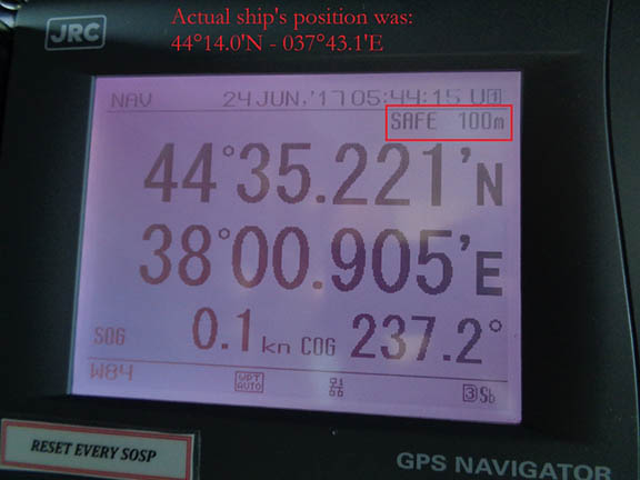
Important: at that time, GPS system considered the position as “Safe within 100m”.
See attached.
Then last night, position was correct despite several “lost GPS fixing position” alarm that raised couples seconds only; then signal was back to normal.
Now position is totally wrong again.
See attached pictures that I took on 24 June at 05h45 UTC (30 min ago).
Note: you can also check websites like MarineTraffic and you will probably notice that once in a while all ships in the area are shifting inland next to each other.
I hope this can help.
To back up his report, the master sent photos of his navigation displays, a paper chart showing his actual position and GPS-reported position, and his radar display that showed numerous AIS contacts without corresponding radar returns.
One of the photos was of the navigation receiver’s “GPS Information Screen.” This has allowed navigation experts to conclude this was a fairly clear, if not subtle, case of “spoofing” or sending false signals to cause a receiver to provide false information, Goward wrote. They point to the receiver saying its antenna is 39 meters underwater, that all the GPS satellites it is using have the same high signal strength, and that the WER, or Word Error Rate, is 97 percent (normal is less than 10 percent).
The RNT Foundation said it has received numerous anecdotal reports of maritime problems with AIS and GPS in Russian waters, though this is the first publicly available, well-documented account, of which they are aware.
“Russia has made no bones about the fact that they have the capability (to interfere with GPS signals),” Goward told Inside GNSS. “They’ve bragged about it.”
With more than 250,000 cell towers in Russia equipped with GPS jamming devices as a defense against attack by U.S. missiles, the country has advanced capabilities to disrupt GPS. There have been press reports of Russian GPS jamming in both Moscow and the Ukraine. In fact Russia has boasted that its capabilities “make aircraft carriers useless,” and the U.S. Director of National Intelligence recently issued a report that stated that Russia and others were focusing on improving their capability to jam U.S. satellite systems, according to the RNT Foundation.
Goward worries that it may take a costly incident or even a death before the Coast Guard and other government agencies get on board with implementing GPS backup infrastructure. He added that we may never get to the bottom of this Black Sea incident since the motivation may not exist to take on the task.
“Everybody’s got priorities,” he said. “There’s never enough money or time to do all the things that you should. Especially in the public sphere. It’s very difficult to capture electioneers and the public’s imagination until there’s that incident where someone dies and it’s on the front page of the papers.”
Goward suggests if indeed Russia was behind the Black Sea navigation problems, it could be for a number of reasons. But regardless, he feels it’s time to do whatever it takes to prevent these types of disruptions.
“Maybe it was to encourage use of the Russian GLONASS satellite navigation system or their terrestrial Loran system, called Chayka, instead of GPS. Perhaps it was for some security reason known only to them,” Goward wrote on the RNT Foundation website.
He told Inside GNSS: “Who’s in charge of figuring out what happened? It was in the Black Sea, so not in U.S. waters. I can virtually guarantee it was not a U.S. flag ship. If the intelligence community figures out what happened, they’re not going to tell anybody. I’m not sure what the motivation for anybody to figure out what happened is. It sounds like a lot of work.”
The former Coast Guard executive did say that the Coast Guard is currently working on new programs to help prevent attacks on GPS systems.
“The Coast Guard is trying hard on cyber security and they consider GPS disruption a cyber security problem,” he said. “They are developing the cyber security guidelines for ports right now.
I’m not sure where they are on cyber security guidelines for ships.”
He did add, however, that the Coast Guard, to date, has not shared any details on the Black Sea incident in terms of explaining what happened or how to avoid this in the future.
These concerns are not new at all. Goward referenced a 2011 incident in which a CIA drone reportedly ended up in the hands of the Iranians, and another case a couple years ago when a Navy boat wandered into Iranian territory unexpectedly.
In the November/December 2016 issue of Inside GNSS, Goward shared his thoughts on GPS resiliency in an article on how GNSS will fare under the Trump administration.
“GPS signals are America’s least visible and most vulnerable infrastructure,” said Goward in that earlier article. “Building an eLoran complement and backup for GPS will make America stronger, create jobs, and eliminate a strategic advantage that countries like China, Russia, and Iran can hold over our heads. An eLoran network should be part of any U.S. infrastructure program.”


