
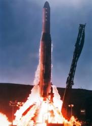
Shadows from a westering sun surrounded the Atlas F rocket — essentially a refurbished ICBM — sitting out on the launch pad along California’s central coast. At Vandenberg Air Force Base, it was shortly before 4 p.m. (Pacific Standard Time) on February 22, 1978.
The payload was a new class of satellites, which had reportedly gained the sobriquet NAVSTAR some years earlier during a conversation in a Pentagon washroom. The name’s official derivation — NAVigation by Satellite RAnging and Timing — would come later.
More widely know today as GPS, the U.S. Global Positioning System was filled with unknowns on that winter afternoon 30 years ago as its first satellite, officially Space Vehicle Number 1 (SVN01), awaited the final countdown.
Among the novel and largely untested (in space, anyway) technologies that NAVSTAR 1 would carry into orbit were spread spectrum radio, atomic clocks, and satellite ranging that employed pseudorandom noise (PRN) signals.
The idea of using middle-earth orbiting satellites to provide real-time, highly accurate positioning was a little tough for U.S. military commanders to wrap their minds around. And, in those chilliest days of the Cold War, the notion of dual civil-military use buried inside GPS’s design left some shaking their heads.
Programmatically, GPS had arisen in late 1973 from the convergence of multiple streams of Department of Defense (DoD) research and a $148 million budget. Despite these separate Air Force, Navy, and Army efforts, the early GPS program lacked support from the military services’ operating commands — which would rather have spent the money on weapons systems. Mission needs, user requirements, and concept of operations were still in the process of being defined.
The underwhelming response had led DoD officials to adopt GPS as an agency-wide initiative and place it under the care of a Joint Program Office with an Air Force colonel acting as the executive manager.
Over the years, the program faced many risks and overcame many obstacles — even defunding by the Air Force in 1980–82. But the launch of SVN01 became a shot heard ‘round the world — now louder than ever.
For a modern technology, the first generation of GPS has had a remarkable shelf life. The Block IIR-M satellites now being launched — although outfitted with new military and civil signals — still transmit the legacy C/A- and P/Y-code signals that first went on the air 30 years ago.
Today, the Global Positioning System is in the midst of far-ranging modernization efforts on the ground and in space. Latter-day GNSS systems have taken many of their cues from GPS, with which they must inevitably be compatible and interoperable in order to share in GNSS’s synergistic benefits.
The trail blazed with launch of SVN01 has become a busy thoroughfare populated by hundreds of millions of users — civil, commercial, and military.February 22, 1978, was a beginning with no end in sight.
The text above is from a commemoration of the 30th anniversary of the Global Positioning System on the cover of the January-February 2008 issue of Inside GNSS magazine. To see all of the historical photos, engineering drawings, and captions on the gatefold display, download the pdf (above.)


