(Updated August 4, 2009)
A GPS community consensus is emerging that the initial proposal for mitigating the L1 signal anomaly causing elevation-dependent ranging errors on the SVN49 satellite isn’t the best approach.
(Updated August 4, 2009)
A GPS community consensus is emerging that the initial proposal for mitigating the L1 signal anomaly causing elevation-dependent ranging errors on the SVN49 satellite isn’t the best approach.
A special panel session on the subject will be held at the Institute of Navigation (ION) GNSS 2009 conference in Savannah, Georgia, on September 23. The panel will be chaired by Mike Shaw, director of navigation systems global business development at Lockheed Martin Space Systems, which built the Block IIR and IIR-M satellite. Among others, Col. Dave Madden, commander of the GPS Wing, will take part.
GNSS engineers at the European Space Operations Center have detected similar, but much less substantial elevation-dependent anomalies on nine other Block IIR and IIR-M satellites, which they describe in an article in the current issue of Inside GNSS.
The first method for dealing with the anomaly (currently implemented) is sort of a one-size-fits-all approach — that is, two corrections to time and orbital position: a broadcast ephemeris about 152 meters higher than the satellite’s actual orbit and a 500-nanosecond time offset.
However, different locations, types of receivers (for example, single- or dual-frequency), and operating modes (for example, carrier phase tracking, local differential, wide area differential) produce a substantial range of results using the this method.
In its place, the most promising new approach involves mapping the orbit of SVN49 (launched March 24 and also known by its pseudorandom noise code PRN01) using observation data collected at GPS monitoring stations and possibly other high-precision reference stations around the world.
This data would be fed into the new Kalman filter used in the tracking, telemetry, and control (TT&C) software used by the GPS Master Control Station at Schriever Air Force Base, Colorado. The Kalman filter and TT&C software were part of a large-scale upgrade of the Operational Control Segment (OCS) implemented September 14, 2007.
Using a distributed computing network that replaced the 1970s-era mainframe computer, navigation controllers from the 2nd Space Operations Squadron (2SOPS), USAF 50th Space Wing, upload information and operational commands to the GPS satellites.
The SVN49 orbit “map” data would become part of the input to the computer and TT&C used in this process. With this more complete data set reflecting actual observations of the satellite at different elevation angles around the world, engineers from the Air Force and contractors working on the problem believe that a more accurate and more generally usable solution can be achieved.
Implementation of the revised solution, however, could be a year away. In the meantime, SVN49 remains in an “early on-orbit check-out” status, and its signals are not considered operational.
For the past several weeks, the GPS Wing has been consulting about the situation with U.S. and international GPS receiver and simulator manufacturers and organizations representing user constituencies.
A recent e-mail inquiry on the Wing’s behalf solicits the opinion of these manufacturers and organizations about the new proposal and what GPS operators should do with SVN49 until the orbit mapping, observation data processing, and incorporation into the OCS Kalman filter can take place — if a decision is made to do so.
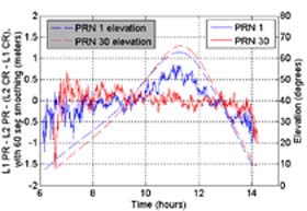
The e-mail asked recipients to assume that the orbit-mapping solution would not take place for 12 months and that, in the meantime, SVN/PRN30, a 13-year-old Block IIA satellite in a nearby orbital slot, remains healthy.
Options include setting SVN49 healthy with the current orbit and time offsets (150 meters, 500 nanoseconds, respectively), leaving the satellite in its check-out or unhealthy status but maintaining the clock and ephemeris offsets, leaving the satellite in the current status but eliminating the offsets, or just setting the satellite unhealthy with a warning in the navigation message’s ephemeris frame that the user range error is higher than normal.
A decision on what to do is probably weeks or a month or so away, and the outcome may be known by the time of the ION GNSS 2009 panel. Shaw, who will chair the session, was the executive director of the U.S. Space-Based PNT National Coordination Office before taking up the Lockheed job earlier this year.
Conceivably, the orbit mapping solution could be extended to the nine other satellites on which lesser versions of the anomaly have been found, resulting in an overall improvement in GPS system performance.
The GPS Wing will also host a public Interface Control Working Group (ICWG) meeting for documents IS-GPS-200 (NAVSTAR GPS Space Segment/Navigation User Interfaces), IS-GPS-705 (NAVSTAR GPS Space Segment/User Segment L5 Interfaces), and IS-GPS-800 (NAVSTAR GPS Space Segment/User Segment L1C Interfaces), September 29–October 1 in El Segundo, California. Although the signal anomaly is not on the official agenda, it may well be a matter of informal discussion.


