 One of 12 magnetograms recorded at Greenwich Observatory during the Great Geomagnetic Storm of 1859
 1996 soccer game in the Midwest, (Rick Dikeman image)
 Nouméa ground station after the flood
 A pencil and a coffee cup show the size of NASA’s teeny tiny PhoneSat
 Bonus Hotspot: Naro Tartaruga AUV
 Pacific lamprey spawning (photo by Jeremy Monroe, Fresh Waters Illustrated)
 “Return of the Bucentaurn to the Molo on Ascension Day”, by (Giovanni Antonio Canal) Canaletto
 The U.S. Naval Observatory Alternate Master Clock at 2nd Space Operations Squadron, Schriever AFB in Colorado. This photo was taken in January, 2006 during the addition of a leap second. The USNO master clocks control GPS timing. They are accurate to within one second every 20 million years (Satellites are so picky! Humans, on the other hand, just want to know if we’re too late for lunch) USAF photo by A1C Jason Ridder.
  Detail of Compass/ BeiDou2 system diagram
 Hotspot 6: Beluga A300 600ST

Dangerous Games in Rio, Animal Trackers, Chinese Logistics and The Radiation Club
Dangerous Games in Rio, Animal Trackers, Chinese Logistics and The Radiation Club
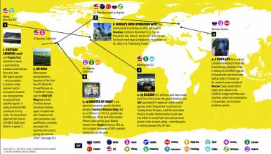
1. DANGEROUS GAMES
Rio de Janeiro, Brazil
√ Brazil’s Olympic preparations are exposing the world to thorny problems the citizenry has to deal with everyday, including Aedes Egypti, the Zika virus’ insect delivery system. But GNSS is there to help! Public health officials have used ArcGIS, Google Earth, and widespread handheld GPS devices to track, map, and target mosquito breeding concentrations and disease outbreaks. Researchers say the next big advancement will be cloud-based, real-time GIS that will enable quicker response. GNSS navigation technology isn’t always helpful in Rio, however, where wealthy areas lie cheek-by-jowl with gang-controlled favelas. Last fall, a couple followed their navigation app to a tourist avenue but ended up in a notoriously dangerous street with the same name. The woman didn’t make it out alive.
2. WINDSWEPT
Grands Causses, France
√ GNSS animal trackers have become so small, light, precise, and cheap that birds have been enlisted in the eternal quest to figure out the weather. Ecologists and engineers from universities in Amsterdam, Ohio, and Montpellier used 22 large Griffon vultures flying in the limestone plateaux of southern France to figure out wind speed and direction and vertical air movement. They used GPS data from trackers taken at three-second intervals and compared it to ground readings. Turned out the birds, which depend on wind movements to dip and soar, could help improve the accuracy of weather observations.
3. LOGISTICS
Zhengzhou, China
√ International online shopping is growing fast in China, and the government is encouraging e-commerce with duty-free warehouse and logistics centers. Of course, BeiDou is key to developing a national smart logistics system. In Zhengzhou, a major transportation hub and population center, the government approved a 63-station ground data center in the city that can increase the accuracy of BeiDou-georeferenced imagery from 10 meters to a few millimeters and provide navigation, precision time synchronization, and velocity measurements for industry and consumers. Li Guangyun, professor at the surveying and mapping institute there told Xinhua news that all of the components are made in China, and the new center is critical to China’s information security.
4. THE RADIATION CLUB
Fukushima, Japan
√ Was it safe? Who knew? After Japan’s 2011 earthquake and tsunami, a bunch of engineers and hackers got together to measure the radioactive fallout from the Fukushima Daiichi nuclear disaster by cobbling together a crowd-sourced Geiger counter. First, a volunteer truck driver wandered the area logging GPS data, snapping pictures, and measuring radioactivity. The group shared information via Skype, met face-to-face in Tokyo, and formed Safecast, a global volunteer citizen science project that collects, maps, and shares radiation data. Five years later, the Fukishima prefecture’s worldwide radiation maps are powered by Safecast data. On the business side, the group has developed a number of mobile and static devices.


