 One of 12 magnetograms recorded at Greenwich Observatory during the Great Geomagnetic Storm of 1859
 1996 soccer game in the Midwest, (Rick Dikeman image)
 Nouméa ground station after the flood
 A pencil and a coffee cup show the size of NASA’s teeny tiny PhoneSat
 Bonus Hotspot: Naro Tartaruga AUV
 Pacific lamprey spawning (photo by Jeremy Monroe, Fresh Waters Illustrated)
 “Return of the Bucentaurn to the Molo on Ascension Day”, by (Giovanni Antonio Canal) Canaletto
 The U.S. Naval Observatory Alternate Master Clock at 2nd Space Operations Squadron, Schriever AFB in Colorado. This photo was taken in January, 2006 during the addition of a leap second. The USNO master clocks control GPS timing. They are accurate to within one second every 20 million years (Satellites are so picky! Humans, on the other hand, just want to know if we’re too late for lunch) USAF photo by A1C Jason Ridder.
  Detail of Compass/ BeiDou2 system diagram
 Hotspot 6: Beluga A300 600ST

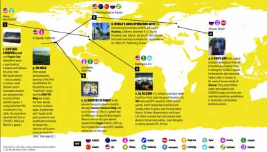
1. COMPASS EXPLAINED
Montreal, Quebec. Canada
√ An International Committee on GNSS Experts Meeting took place July 15 in Montreal, Canada, with updates on GNSS system developments. A Chinese representative detailed the Compass (Beidou II) signals: 10 services — five free “open” services, and five restricted “authorized” services — centered at eight different carrier frequencies. (See related news article in this issue.)
2. HURRICANE HELP
Gulf Coast, USA
√ Just push the button and a crisis advisor will be there for you – that’s what OnStar told its customers in hurricane-prone southeastern USA. The automobile calling system and GPS locator service offers “Crisis Assist” to help customers get out of the way of Gustav. On August 31, 2008, OnStar saw a 30 percent increase over typical call volume
3. LOST ON THE MOON
Off the Map
√ Astronauts who return to the moon in 12 years or so may depend on NASA’s Lunar GPS to keep from getting lost. Now in development, the LASOIS technology will keep people oriented through lunar beacons, stereo cameras, and orbital imaging sensors on vehicles, robots, and spacesuits.
4. ERASING HISTORY?
Worcester, UK
√ At an August conference in London, the president of the British Cartographic Society said that GPS devices and interactive maps are “destroying thousands of years of history.” Databases omit landmarks and people don’t learn basic navigation skills. Worcester Cathedral, for example, built in 1084, is missing from a Google map.
5. AIRPORT MODERNIZATION
Mumbai, India
√ The Airports Authority of India (AAI) implemented area navigation (RNAV) procedures at Delhi, Mumbai and Ahmedabad airports on August 28, as part of its performance-based navigation (PBN) program. The PBN effort will be bolstered by the launch of the first GPS Aided GEO Augmented Navigation (GAGAN) payload later this year.
6. EAT AT ZHOU’S
Beijing, China
√ China devised a system that used GPS and RFID labels to track and monitor all of the food grown, processed and transported to Beijing for the Olympics. The “Olympic Food Safety Logistics Code” was an effort to solve the touchy problem of suppliers who violate safety regulations.


