Spirent Communications has launched GNSS Foresight, a cloud-based solution that empowers GNSS users with advance knowledge about the strength and reliability of GNSS signals in exact locations within their operational areas. The service will have early application for aviation, unmanned and autonomous platforms, but Spirent VP Jeremy Bennington told Inside GNSS that its potential is far wider.
“The next step is using Foresight data to improve the performance of all GNSS receivers. Can we extract more accuracy, more reliability if we know which satellites are best to be used in a particular environment? Yes.”
Simply put, Foresight can improve performance in reliability and integrity.
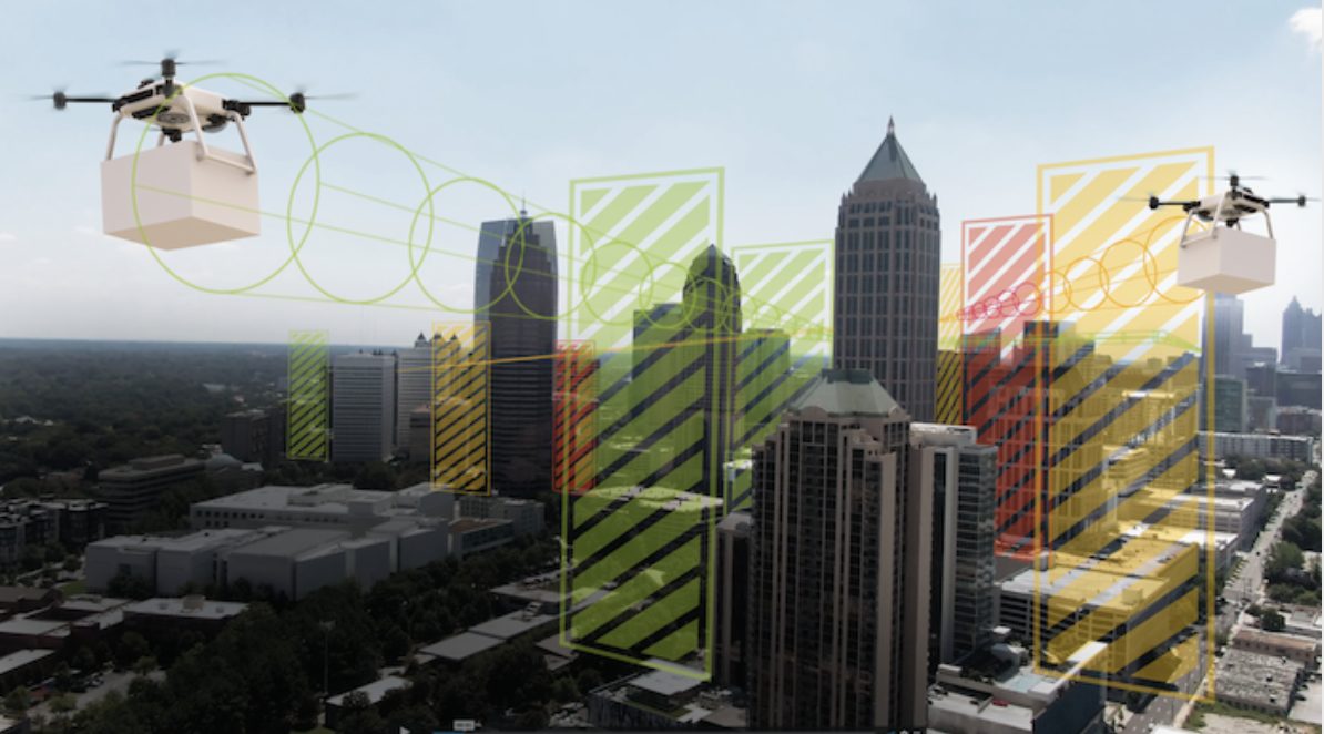
By letting operators know in advance where and when GPS or GNSS positioning is reliable, GNSS Foresight accurately predicts where and when unmanned vehicles, air taxis and drones can operate safely and dependably beyond visual line of sight (BVLOS), especially in urban areas where buildings frequently obstruct GNSS signals.
The service is the first of its kind and addresses one of the key issues facing developers and operators of unmanned aerial (UAS) and autonomous vehicles. Because GNSS performance can be unpredictable in urban and suburban areas due to signals being obscured or blocked by buildings, autonomous systems have not been able to rely on GNSS for accurate positioning.
Foresight leverages the existing GNSS capability of aircraft and the equipped airspace. “Drones and electric vertical takeoff and landing (E-VTOL) air taxis have a pent-up demand,” said Bennington, Spirent’s Vice President of PNT Assurance. “They have to build the public perception they can perform safely and provide a useful service. They also have to demonstrate to policy makers that this can be done safely.” Foresight offers the potential to do that.
The capabilities of Foresight were demonstrated in a free Inside GNSS webinar on August 11, available now for download here. (See further notes at the bottom of this article.)
After the webinar, Bennington related, “We went to the Association for Unmanned Vehicle Systems International (AUVSI) XPONENTIAL show — and we didn’t sit down for a week! It was non-stop for us, incredible interest from the aviation and E-VTOL air taxi communities to have more reliable navigation and safety for their aircraft.”
“The ability to have Foresight as an advisory service as part of their thinking, to make sure they can comply to the existing standards, that really resonates.”
GNSS Foresight’s ability to accurately predict where and when their autonomous systems will perform enables users to scale their operations or services by expanding operational areas, reducing the number of system disengagements, and providing a greater level of safety and reliability assurance when reducing — or ultimately removing — human involvement in the driving or piloting task.
“GNSS Foresight overcomes navigation and positioning challenges by providing real-world situational awareness ahead of time for pre-flight, or for real-time performance improvement, through a cloud-based service,” said Bennington. “It can be used to determine areas that are always safe to fly or operate in, in addition to finding the exact time in a degraded area that specific operational requirements can be met. GNSS Foresight enables operators to enhance efficiency, safety and ROI through the resulting operational improvements.”
Beyond BVLOS to PNT Industry-Wide Application
According to Bennington, this data could be used by any GNSS receiver to improve its performance. “One of the challenges for a receiver is, it doesn’t have any situational awareness. It has an omnidirectional antenna and doesn’t know where signals are coming from. A lot of work has been done to reject multipath or, alternately, to extract information from those multipath signals.
“Foresight helps you do that. If you know a signal is multipath, that’s important information. Among several signals that the receiver is getting, how do I choose the five best? Right now it’s based on signal strength. But a multipath signal or a spoofed signal can be strong too. Foresight can tell you if that strong signal is actually line-of-sight and safe to use or if it is likely multipath or spoofed. Foresight provides an additional level of information about where those signals are coming from, and helps you know how best to use them at an instant or in motion.”
Design and Test. Now Operate.
Bennington is the first person to have the title of Vice President of PNT Assurance, a division created two years ago by Spirent. Spirent’s positioning business unit has had two shifts in its thinking over the last decade, according to him. The first was: evolving its GNSS business to suit the requirements of a modern multi-sensor PNT engines. Many industries have developing needs for precise PNT, and are fusing sensor technologies to achieve this. Taking this evolution into account, Spirent has extended its leadership by building systems to integrate and test with other sensors that may be on a PNT platform.
A second shift took place two years ago, where Spirent took its unique capability from simulation and testing into assurance – helping customers operate their systems, assuring they can use these systems in the real world. Lab testing gives a clear indication of the conditions a device can operate under, and now Spirent is giving users the power to find those conditions in the real world. This change represents the broader Spirent group, where lab-and-live models are delivered to customers.
Benchmarking RTK
With the trend in new augmentation and RTK services for increased position accuracy, users more than ever want to understand performance in their specific locations and drive routes.. “Imagine an RTK provider using Foresight to tell you not only where it’s available but how well it will work: where you can get 10 centimeter, and where you can get 1 centimeter.”
“We all have a common goal,” he concluded. “How do we get more out of these GNSS systems that exist in nearly every vehicle and consumer device in the world? Once we’ve done that, we can then fill the gaps with other technologies.”
GNSS Foresight can produce forecasts using data from any of the world’s satellite constellations, and is of particular interest to the aviation and UAS sector, as well as the automotive industry. It is now being shown publicly for the first time at ION GNSS+ in St Louis (September 22 – 24).
Free Webinar
Takeaways from the in-depth technical tutorial, The Tools Needed to Get Beyond Visual Line-of-Sight (BVLOS), available now for download, include:


